

Dry Air Holds Over Far North Alabama
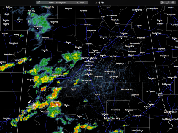
RADAR CHECK: Showers and storms are moving eastward across Central Alabama… mostly south of a stalled surface front from near Hamilton to Oneonta to Heflin…
Those north of the front, up in the Tennessee Valley, are enjoying lower humidity levels and a very pleasant day. But, muggy tropical air will push northward tonight… we all know that shots of dry, continental air don’t last long this time of the year.
The showers and storms over Central Alabama will wind down later this evening once the sun goes down.
TOMORROW THROUGH FRIDAY: The upper ridge will rebuild across the Deep South, setting up some classic August weather each day. Partly sunny, hot, humid, and the risk of “scattered, mostly afternoon and evening showers and storms”. The storms will be widely scattered, generally speaking, than last week. Highs will be mostly in the low 90s; a few spots could reach the mid 90s late in the week.
THE ALABAMA WEEKEND: It’s a persistence forecast. No real change… highs 90-95, partly sunny days, with a passing shower or storm possible during the afternoon and evening hours. And, of course, the storms on summer afternoons here are very random and scattered, and there is no way of knowing in advance where and when they pop up.
The same pattern holds into next week as the upper ridge remains in place. See the Weather Xtreme video for maps, graphics, and more details.
AT THE BEACH: About 8 to 10 hours of sunshine daily on the coast through the weekend (from Panama City Beach over to Gulf Shores)… widely scattered showers and storms remain possible each day, but nothing widespread. Highs on the immediate coast in the upper 80s, with low to mid 90s inland. See a very detailed Gulf Coast forecast here.
TROPICAL TRIO: As you might expect, we have action in the Atlantic basin.
FIONA: This is a weakening tropical depression hanging on for dear life; it should dissipate over the next day or two over the open water of the Central Atlantic; no threat to land.
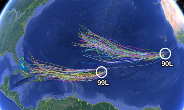
90L: This is a well organized tropical wave in the eastern Atlantic; it has a high chance of becoming Tropical Storm Gaston within the next 24 hours. But, it will be gaining latitude, and should recurve over the open water. Like Fiona, this seems to be no threat to land.
99L: This wave has a chance of slow development in coming days; it is currently fighting dry air surrounding the system. Most models bring this to a point east of the Bahamas in five days; it is simply too early to know if this will recurve over the open Atlantic, or be a threat to the U.S. Atlantic coast. Odds are high this will not impact the Gulf of Mexico.
See the Weather Xtreme video for more details on the tropics.
WEATHER BRAINS: Don’t forget you can listen to our weekly 90 minute netcast anytime on the web, or on iTunes. This is the show all about weather featuring many familiar voices, including our meteorologists here at ABC 33/40. We will produce this week’s show tonight at 8:30p CT… you can watch it live here.
CONNECT: You can find me on all of the major social networks…
Facebook
Twitter
Google Plus
Instagram
Look for the next Weather Xtreme video here by 7:00 a.m. tomorrow…
Category: Alabama's Weather
About the Author (Author Profile)
James Spann is one of the most recognized and trusted television meteorologists in the industry. He holds the AMS CCM designation and television seals from the AMS and NWA. He is a past winner of the Broadcast Meteorologist of the Year from both professional organizations.Subscribe
If you enjoyed this article, subscribe to receive more just like it.


