

Routine August Weather For Alabama; Active Tropics
HOT WEATHER: Just because school is back in session, that doesn’t mean that the weather magically cools down in Alabama. Keep in mind this is still August, and the weather should be hot and humid this time of the year. And, as an upper ridge begins to rebuild across the Deep South, we have some pretty classic August weather coming up in the days ahead.
Each day through Friday, expect a partly sunny sky with widely scattered showers and storms around during the afternoon and evening hours. Chance of any one spot getting wet is about one in four, and highs will be generally in the low 90s. A few spots could reach the mid 90s Thursday and Friday under the ridge.
THE WEEKEND: The synoptic pattern won’t change, and there is no real reason to change the forecast. Highs 91-95 degrees, partly sunny days, fair nights, and the risk of widely scattered showers and storms during the afternoon/evening hours, generally between 2 and 8 p.m.
And, the same general idea continues into early next week, unless by chance we have some tropical mischief around here.
TROPICAL TRIO: We still have three systems to discuss in the Atlantic basin this morning…
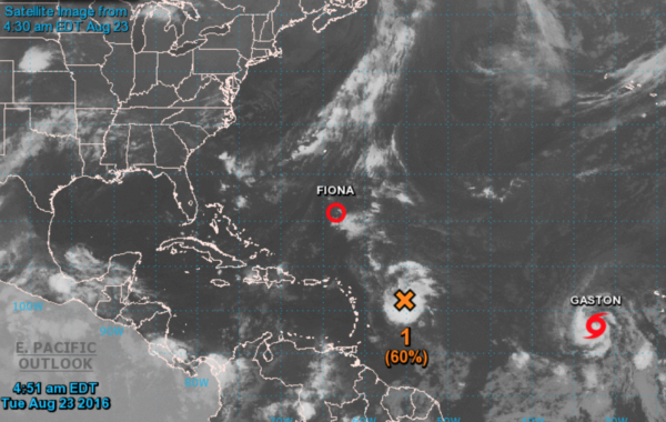
TROPICAL DEPRESSION FIONA: This one is hanging on in the open Atlantic, and should dissipate between the U.S. coast and Bermuda over the next few days. No threat to land.
TROPICAL STORM GASTON: It is in the eastern Atlantic, and should become a hurricane soon. But, it will gain latitude and this will recurve; no threat to land.
INVEST 99L: Clearly this is the most intriguing system on the board, and is the one to watch. Some slow development is possible through mid-week, and it could become Tropical Storm Hermine by the end of the week as it moves north of Puerto Rico toward the Bahamas.
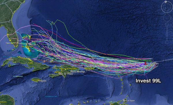
From the position near the Bahamas, this could recurve into the Atlantic, or move westward into South Florida. The strength of the ridge north of the system will determine this, and model consistency has not been especially good. We note there has been a shift to the left in model output over the past 24 hours, and a number of the GFS and ECMWF ensemble members do indeed make this a threat to the Florida Peninsula.
One way or another, there is a high chance this turns northward before reaching Alabama, but still too early in the game to know for sure. Once the system becomes better organized, and we get better sampling of the atmosphere in the region of the storm, forecast confidence will go higher.
See the Weather Xtreme video for all the maps, graphics, and more details.
AT THE BEACH: Great weather on the Gulf Coast through the weekend; about 8 to 10 hours of sunshine daily with just a few widely scattered showers and storms from Gulf Shores over to Panama City Beach. Highs hold in the upper 80s on the immediate coast, with low to mid 90s inland. See a very detailed Gulf Coast forecast here.
WEATHER BRAINS: Don’t forget you can listen to our weekly 90 minute netcast anytime on the web, or on iTunes. This is the show all about weather featuring many familiar voices, including our meteorologists here at ABC 33/40. Scroll down for the show notes on the new episode we recorded last night…
CONNECT: You can find me on all of the major social networks…
Facebook
Twitter
Google Plus
Instagram
Look for the next Weather Xtreme video here by 4:00 this afternoon… enjoy the day!
Category: Alabama's Weather
About the Author (Author Profile)
James Spann is one of the most recognized and trusted television meteorologists in the industry. He holds the AMS CCM designation and television seals from the AMS and NWA. He is a past winner of the Broadcast Meteorologist of the Year from both professional organizations.Subscribe
If you enjoyed this article, subscribe to receive more just like it.


