

Midday Nowcast: Hot And Humid, Tropics Are Active
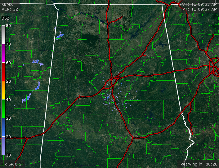
Skies at this hour across much of Central Alabama are mostly clear, with the exception being the northwestern parts of the area as there are a few more clouds moving to the east. There is one shower that has popped up in the extreme northern part of Marion County and the southern part of Franklin County. Currently it is slowly moving to the east-northeast.
TEMPERATURES AT THIS HOUR: Heat is building as we start to reach the daytime maximum temperatures for the day across the area. Here is a list of temperature observations from across the area:
Birmingham 86
Tuscaloosa 88
Gadsden 82
Anniston 86
Haleyville 81
Jasper 88
Alabaster 84
Alexander City 90
Montgomery 90
Selma 86
WHAT TO EXPECT FOR TODAY: We are back to a typical summertime weather pattern across Central Alabama for today. It will be hot and humid out there this afternoon, with a small risk for widely scattered showers and thunderstorms. Afternoon highs will be at or just over 90 degrees for the most part. The odds of any one spot getting rain today will be around one in four.
CODE YELLOW AIR QUALITY: The Air Quality Index for the Birmingham Metropolitan Area will be in the “Code Yellow” for ozone and particulate matter 2.5. Unusually sensitive people should consider limiting prolonged outdoor exertion.
TODAY’S CLIMATOLOGY FOR BIRMINGHAM: The normal high for August 23rd is 90, while the normal low is 68. The record high for today was set back in 2007 at 105. The record low was set back in 1950 at 54.
WEDNESDAY’S WEATHER: Much of the same news for tomorrow, as it looks like the typical summertime weather pattern will be in place at least until Friday. It will be hot and humid, with partly to mostly clear skies, and a small risk for widely scattered afternoon showers and thunderstorms. Afternoon highs will mostly be in the low 90s, with a few spots reaching the mid 90s. The odds of any one spot getting rain today will be around one in four.
HEADED TO THE BEACH: Great weather on the Gulf Coast through the weekend; about 8 to 10 hours of sunshine daily with just a few widely scattered showers and storms from Gulf Shores over to Panama City Beach. Highs hold in the upper 80s on the immediate coast, with low to mid 90s inland. See a very detailed Gulf Coast forecast here.
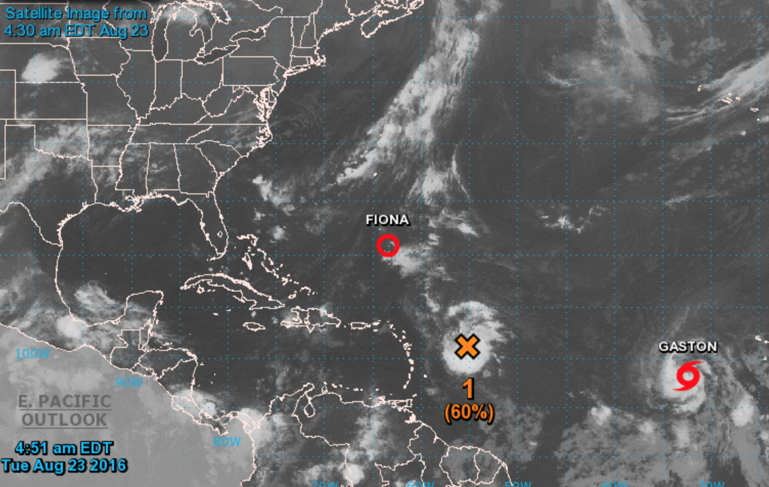
TROPICAL STORM FIONA: This one is hanging on in the open Atlantic, and should dissipate between the U.S. coast and Bermuda over the next few days. No threat to land.
TROPICAL STORM GASTON: It is in the eastern Atlantic, and should become a hurricane soon. But, it will gain latitude and this will recurve; no threat to land.
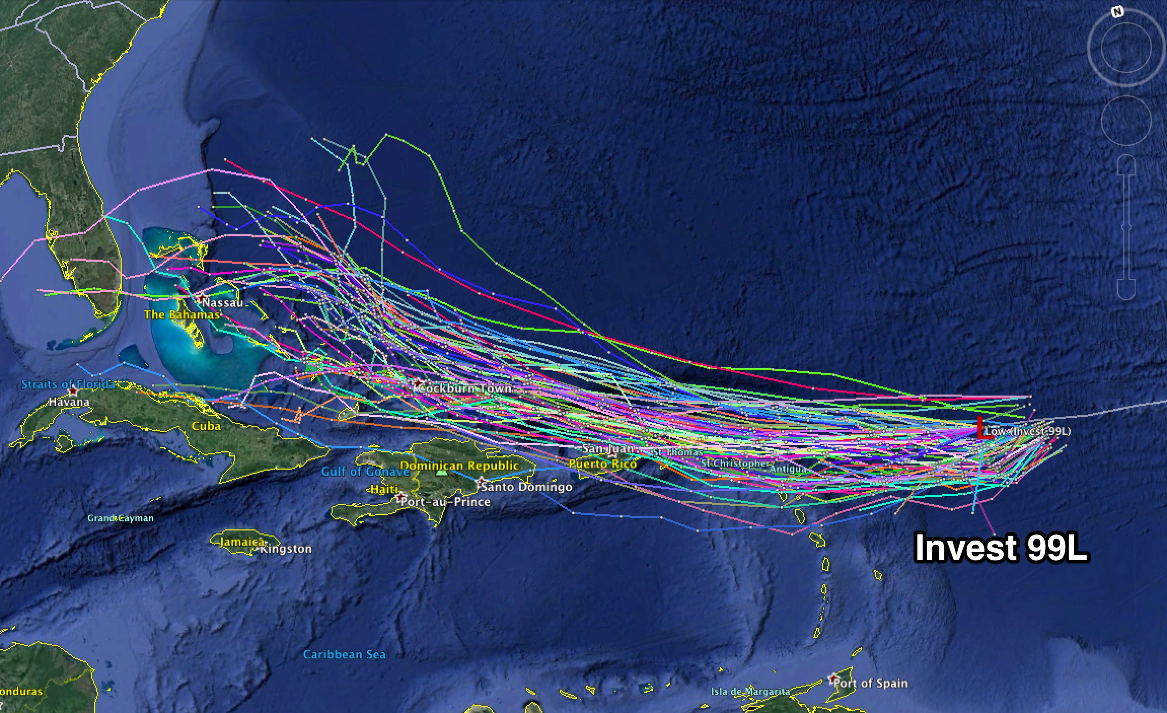
INVEST 99L: This is the one that we need to watch. Slow development is expected through the rest of the week and may become Tropical Storm Hermine by the end of the week as it moves north of Puerto Rico toward the Bahamas. At this point, model consistency has not been good, but latest runs over the past 24 hours has a shift to the left in its projected track, making it a threat tot he Florida Peninsula. Its too early to be able to tell where exactly it will go, but once the system becomes better organized, we can get a better idea.
ON THIS DATE IN 1988: Thunderstorms produced hail an inch in diameter, wind gusts to 64 mph, and 2.62 inches of rain at Tucson AZ resulting in three million dollars damage. Cool weather prevailed in the northeastern U.S. Hartford CT reported a record low of 42 degrees.
WEATHERBRAINS: This is the show all about weather featuring many familiar voices, including our meteorologists at ABC 33/40. You can listen anytime on the web, or on iTunes. You can find it here.
ADVERTISE WITH US: Deliver your message to a highly engaged audience by advertising on the AlabamaWX.com website. The site enjoyed 10.2 MILLION pageviews in the past 12 months. Don’t miss out! We can customize a creative, flexible and affordable package that will suit your organization’s needs. Contact Bill Murray at (205) 687-0782.
Category: Alabama's Weather
About the Author (Author Profile)
Scott Martin is an operational meteorologist, professional graphic artist, musician, husband, and father. Not only is Scott a member of the National Weather Association, but he is also the Central Alabama Chapter of the NWA president. Scott is also the co-founder of Racecast Weather, which provides forecasts for many racing series across the USA. He also supplies forecasts for the BassMaster Elite Series events including the BassMaster Classic.Subscribe
If you enjoyed this article, subscribe to receive more just like it.


