

Eyes On The Tropics
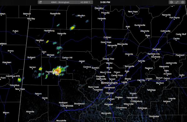
RADAR CHECK: We have a few widely scattered showers and storms this afternoon, mainly over Northwest Alabama… moving eastward. Nothing widespread, and many places are dry…
Temperatures are pretty close to 90 degrees in most places.
REST OF THE WEEK AND THE WEEKEND: With an upper ridge in place, we really don’t expect much day to day weather change through the weekend. Partly sunny, hot, humid days with “widely scattered, mostly afternoon and evening showers and thunderstorms” each day. Highs mostly in the low 90s… a few spots could ease up into the mid 90s late this week. Way too early to be thinking about cool, crisp, autumn weather. First good front of the season usually arrives in mid to late September, about a month from now.
The weather next week will depend on the tropical weather situation, which gathers most of the attention this afternoon…
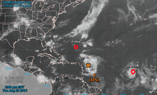
FIONA IS FINISHED: The depression is now an open wave, and advisories are no longer being issued by NHC. We will keep eye on the “ghost of Fiona”, but odds of regeneration are small.
TROPICAL STORM GASTON: Should become a hurricane tonight or tomorrow in the eastern Atlantic. It will be gaining latitude, and should recurve into the open Atlantic, and is no threat to land.
INVEST 99L: This is the one that will produce weeping and gnashing of teeth over the next 5 to 7 days. Let’s make some important points about this wave, which is nearing the Leeward Islands this afternoon:
*There is a chance this won’t develop at all due to dry air and shear. Unlikely, but a chance.
*A hurricane hunter was in the system today, and could not find a closed circulation. This isn’t even a tropical depression now, and until it gets it’s act together, forecasting future positions and intensity is very challenging.
*Tropical models are tightly clustered; pushing the system to the Bahamas in five days.
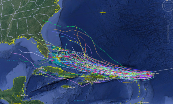
*Beyond that, there is little agreement in global models concerning the long term destination. The 12Z GFS (American) model basically dissipates the system around the Bahamas, with no threat to the U.S. However, the 12Z ECMWF (European) model moves it across the Florida Peninsula, and into the Gulf of Mexico, with a landfall near Gulf Shores next Tuesday night. Understand that run of the Euro is an outlier; taking the ensemble approach, a more likely track is over South Florida, with a turn to the north well east of Alabama.
*Nobody, and I mean nobody knows the ultimate destination and intensity of this, IF it develops at all. We all just need to pay attention, and forecast confidence will grow in coming days.
See the Weather Xtreme video for maps, graphics, and more details.
WEATHER BRAINS: Don’t forget you can listen to our weekly 90 minute netcast anytime on the web, or on iTunes. This is the show all about weather featuring many familiar voices, including our meteorologists here at ABC 33/40.
CONNECT: You can find me on all of the major social networks…
Facebook
Twitter
Google Plus
Instagram
Look for the next Weather Xtreme video here by 7:00 a.m. tomorrow…
Category: Alabama's Weather
About the Author (Author Profile)
James Spann is one of the most recognized and trusted television meteorologists in the industry. He holds the AMS CCM designation and television seals from the AMS and NWA. He is a past winner of the Broadcast Meteorologist of the Year from both professional organizations.Subscribe
If you enjoyed this article, subscribe to receive more just like it.


