

Hot, Muggy Alabama Weather; Active Tropics
RIDGE RULES: The upper ridge will hold across Alabama and the Deep South through the weekend, meaning little day to day change in our weather; partly sunny, hot, humid days with widely scattered showers and thunderstorms, generally during the afternoon and evening hours (2-8 p.m.). The chance of any one spot seeing a shower or storm today is about one in four, and the high will be in the low 90s. A few communities could see mid 90s by Friday, but highs will be mostly in the 90-94 degree range through Sunday.
This is just what you expect in August in Alabama. Then, next week, our weather will all depend on the tropical weather situation, which will dominate the discussion this morning.
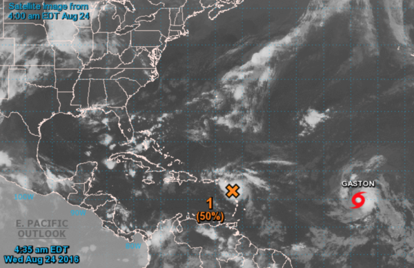
GASTON: The tropical storm in the Central Atlantic should become a hurricane today, it will move more northward, and should recurve over the open water east of Bermuda, and is no threat to land.
INVEST 99L: This is the one getting all the attention simply because it has a decent chance of impacting some part of the U.S. Here is the current thinking…
*Seems like a CDO (central dense overcast) is developing early this morning, meaning there is a chance the wave is finally beginning to get it’s act together.
*Slow development is likely over the next few days, and confidence is high the system will pass just north of Puerto Rico and Hispaniola, reaching the Bahamas this weekend.
*It is very important to understand that forecasting the track and intensity will be almost impossible until we get a well defined low level circulation center, and a better sampling of the environmental conditions by NOAA’s Gulfstream-IV jet. We all play the “model map” game, but it is still more of a “guessing game” at this early phase of the game.
*Could this move across South Florida and into the Gulf of Mexico? Yes. But, not a certainty. If it does, it could wind up anywhere from Galveston to Panama City Beach next week. Nobody knows; no need to cancel vacation plans.
*If this becomes a tropical storm, the name will be “Hermine”… (her-MEEN)
Just keep up with the blog posts in coming days, and a much higher forecast solution will evolve. But you need to be working with current information. See the Weather Xtreme video for all the maps and more details.
AT THE BEACH: Very nice weather continues on the Gulf Coast from Panama City Beach over to Gulf Shores through the weekend; about 8 to 10 hours of sunshine daily with widely scattered showers or storms. Highs in the upper 80s on the immediate coast, with low to mid 90s inland. If a tropical system does get into the Gulf of Mexico, there will be no impact until sometime next week (if there is any impact at all). See a very detailed Gulf Coast forecast here.
WEATHER BRAINS: Don’t forget you can listen to our weekly 90 minute netcast anytime on the web, or on iTunes. This is the show all about weather featuring many familiar voices, including our meteorologists here at ABC 33/40.
CONNECT: You can find me on all of the major social networks…
Facebook
Twitter
Google Plus
Instagram
I will be at Children’s of Alabama this morning doing a weather program… look for the next Weather Xtreme video here by 4:00 this afternoon. Enjoy the day!
Category: Alabama's Weather
About the Author (Author Profile)
James Spann is one of the most recognized and trusted television meteorologists in the industry. He holds the AMS CCM designation and television seals from the AMS and NWA. He is a past winner of the Broadcast Meteorologist of the Year from both professional organizations.Subscribe
If you enjoyed this article, subscribe to receive more just like it.


