

Midday Nowcast: Hot And Humid, Scattered Showers Are Out There
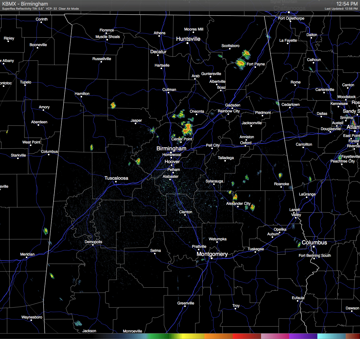
For the most part, skies across Central Alabama are mostly clear at this hour, but we do spot some scattered shower activity popping up on radar already. Right now, the hot spot for shower activity is located in northern Jefferson, southwestern Blount, and eastern Walker Counties. Another small shower has popped up in southwestern Winston County, and a few more located in southern Clay and northern Tallapoosa Counties.
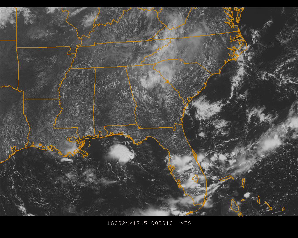
Looking at the southeastern United States, most areas are high and dry at this time, with the only hot spots for shower activity being in northern Georgia and the southern half of the Florida Peninsula. Skies are mostly clear otherwise except for the mountain areas of eastern Tennessee, western North and South Carolina, and western Virginia.
TEMPERATURES AT THIS HOUR: Here is a list of temperature observations from across the area at this hour:
Birmingham 90
Tuscaloosa 90
Gadsden 88
Anniston 88
Cullman 87
Jasper 93
Alexander City 90
Selma 90
Montgomery 88
CODE YELLOW AIR QUALITY: The Air Quality Index for the Birmingham Metropolitan Area is in the “Code Yellow” for ozone and particulate matter 2.5. Unusually sensitive people should consider limiting prolonged outdoor exertion.
TODAY’S CLIMATOLOGY FOR BIRMINGHAM: The normal high for August 24th is 89, while the normal low is 68. The record high for today was set back in 1924 at 103. The record low was set back in 1997 at 57.
REMAINDER OF TODAY: Another typical summertime day expected across Central Alabama. It will be hot and humid out there this afternoon, with a small risk for widely scattered showers and thunderstorms. Afternoon highs will be in the low 90 degrees for the most part, with a few places flirting with the mid 90s. The odds of any one spot getting rain today will be around one in four.
THURSDAY’S WEATHER: Much of the same news for tomorrow, as it looks like the typical summertime weather pattern will be in place for a while. It will be hot and humid, with partly to mostly clear skies, and a small risk for widely scattered afternoon showers and thunderstorms. Afternoon highs will mostly be in the low 90s, with a few spots reaching the mid 90s. The odds of any one spot getting rain today will be around one in four.
HEADED TO THE BEACH: Very nice weather continues on the Gulf Coast from Panama City Beach over to Gulf Shores through the weekend; about 8 to 10 hours of sunshine daily with widely scattered showers or storms. Highs in the upper 80s on the immediate coast, with low to mid 90s inland. If a tropical system does get into the Gulf of Mexico, there will be no impact until sometime next week (if there is any impact at all). See a very detailed Gulf Coast forecast here.

THE TROPICS: The latest update from the National Hurricane Center still have Invest 99L as a tropical wave, but they are expecting it to strengthen to a tropical depression or storm at anytime during the next day or two. As James said in his post from earlier this morning, forecasting the track and intensity will be almost impossible until we get a well defined low level circulation center. If this becomes a tropical storm, it will be Hermine.
As far as Tropical Storm Gaston, it is knocking on the door of being a hurricane. Maximum sustained winds are at 70 MPH, and minimum pressure is at 999 mb. Good news is that Gaston should recurve over the open waters east of Bermuda and will be no threat to land.
ON THIS DAY IN 1988: Thunderstorms in the Delaware Valley of eastern Pennsylvania produced wind gusts to 95 mph around Philadelphia, and gusts to 100 mph at Warminster. A tropical depression drenched the Cabo Rojo area of southwestern Puerto Rico with up to ten inches of rain. San Juan received 5.35 inches of rain.
THE BLOG IS ON TWITTER: Be sure to follow the Alabama Wx Weather Blog on Twitter. Just click here to start following our feed.
WEATHERBRAINS: This week, we previewed the upcoming National Weather Association Annual Meeting with the President, Executive Director, Social Media Chair and Program Chair. This is the show all about weather featuring many familiar voices, including our meteorologists at ABC 33/40. You can listen anytime on the web, or on iTunes. You can find it here.
ADVERTISE WITH US: Deliver your message to a highly engaged audience by advertising on the AlabamaWX.com website. The site enjoyed 10.2 MILLION pageviews in the past 12 months. Don’t miss out! We can customize a creative, flexible and affordable package that will suit your organization’s needs. Contact Bill Murray at (205) 687-0782.
Category: Alabama's Weather
About the Author (Author Profile)
Scott Martin is an operational meteorologist, professional graphic artist, musician, husband, and father. Not only is Scott a member of the National Weather Association, but he is also the Central Alabama Chapter of the NWA president. Scott is also the co-founder of Racecast Weather, which provides forecasts for many racing series across the USA. He also supplies forecasts for the BassMaster Elite Series events including the BassMaster Classic.Subscribe
If you enjoyed this article, subscribe to receive more just like it.


