

Hot, Humid Days; Eyes On The Tropics
RADAR CHECK: We have a random pattern of widely scattered showers and storms across Alabama this afternoon… they are drifting to the southwest.
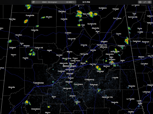
Away from the showers, temperatures are mostly in the low 90s with a partly sunny sky. The showers will fade quickly after sunset.
TOMORROW THROUGH SUNDAY: The upper ridge holds, and our weather just won’t change much. Partly sunny, hot, humid days with widely scattered, mostly afternoon and evening showers and thunderstorms. Highs mostly in the 91-95 degree range.
And, for now, we expect this kind of weather to continue well into next week, unless we have a surprise from the tropics.
EVERYBODY IS TALKING ABOUT 99L: I am convinced Invest 99L is the most publicized open tropical wave in history… partly because of social media, and partly because we haven’t had any hurricane activity around here in many years. Here is the latest this afternoon…
*Air Force Hurricane Hunters again today could not find a low level circulation. In fact, they found no tropical storm force winds and a very disorganized system. It is hanging on for dear life due to a high amount of shear within the atmosphere in the vicinity of the wave, and interaction with Hispaniola.
*There is a very real possibility 99L never develops into a tropical storm or hurricane. But, if the thing can survive, shear values are lower over the Southeast Gulf of Mexico, and SSTs (sea surface temperatures) are very warm, meaning it could try and get it’s act together there.
*Tropical models have shifted to the left today, which is to be expected with a weak, disorganized wave. Understand this model output doesn’t mean very much at this phase of the game.
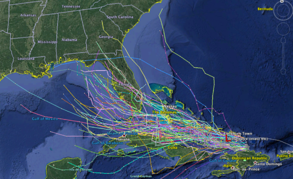
*The European global model (the ECMWF), suggests a weak tropical storm will form just off the west coast of Florida, moving northward toward Apalachee Bay. This scenario would bring lots of rain to the Florida Peninsula (not the panhandle), and keep the main impact east of Alabama. But again, this is just one possible scenario.
*Nobody at this point knows if 99L survives. And, if it does, nobody knows the track and intensity. We are all still in the “wait and see” mode. Interests in Florida and around the Gulf need to keep an eye on it.
GASTON: Now a tropical storm in the Central Atlantic, this one will recurve east of Bermuda and is no threat to land.
AT THE BEACH: About 8 to 10 hours of sunshine daily on the Gulf Coast from Gulf Shores over to Panama City Beach through the weekend, with the usual risk of widely scattered showers and thunderstorms. Highs in the upper 80s on the immediate coast, with low to mid 90s inland. Sea water temperatures are in the mid to upper 80s. See a very detailed Gulf Coast forecast here.
WEATHER BRAINS: Don’t forget you can listen to our weekly 90 minute netcast anytime on the web, or on iTunes. This is the show all about weather featuring many familiar voices, including our meteorologists here at ABC 33/40.
CONNECT: You can find me on all of the major social networks…
Facebook
Twitter
Google Plus
Instagram
I had a great time today visiting with a large home school group in Tuscaloosa at Covenant Presbyterian Church… be looking for them on the Pepsi KIDCAM today at 5:00 on ABC 33/40 News! The next Weather Xtreme video will be posted here by 7:00 a.m. tomorrow…
Category: Alabama's Weather
About the Author (Author Profile)
James Spann is one of the most recognized and trusted television meteorologists in the industry. He holds the AMS CCM designation and television seals from the AMS and NWA. He is a past winner of the Broadcast Meteorologist of the Year from both professional organizations.Subscribe
If you enjoyed this article, subscribe to receive more just like it.


