

First Eight, Now Nine
Earlier today we announced the birth of Tropical Depression Eight. Now, just six and a half hours later, we have Tropical Depression Nine.
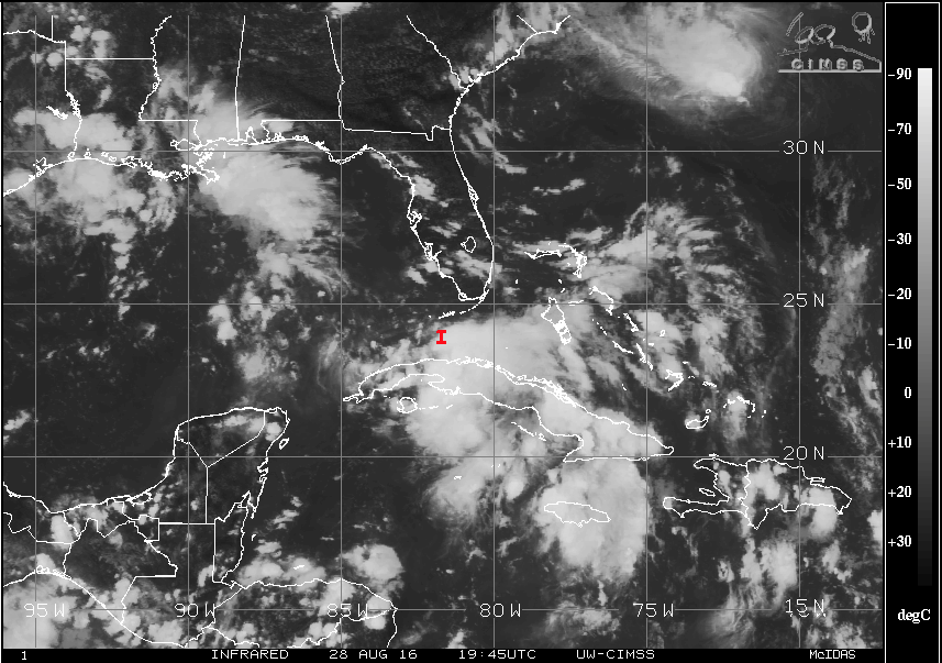
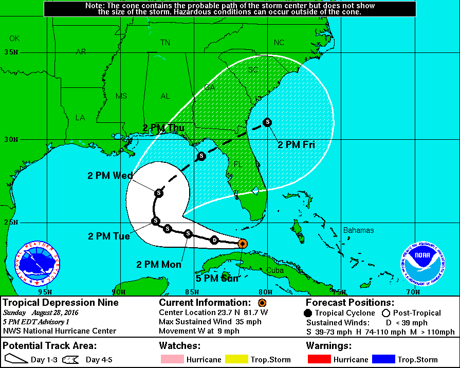
Data from a NOAA Hurricane Hunter aircraft this afternoon indicated that the area of low pressure located in the Florida Straits had a well-defined center. Satellite imagery also showed a significant increase in the convective organization today, so NHC has now classified this system a tropical cyclone. The initial intensity is set to 30 knots based on the highest reliable wind data from the aircraft. The aircraft also reported a central pressure of 1009 mb. Interesting that this is actually a lower pressure than the 06Z GFS run projected this morning.
The depression is still moving through a marginal environment for intensification and will be doing so for the next day or so. Only slow strengthening can be expected during the short term. After a day or so, the environment should improve a little as the shear is forecast to decrease somewhat and become southwesterly, which should permit a little more strengthening. But there are some mixed signals from the models. The ECMWF is now showing the cyclone dissipating in the Gulf while the GFS delays development until 4-5 days. The 00Z run of the ECMWF was much stronger this morning, but no most of the tropical cyclone guidance is more aggressive. Given this uncertainty, the NHC intensity forecast is conservative and shows the system peaking at 45 knots, below all the explicit intensity guidance. As you can probably imagine, confidence in the intensity forecast is even lower than
usual for this system, something we’ve seen throughout its history.
The initial motion estimate is 270 degrees at 9 knots, but the confidence here is low, too, given the recent formation of the center with little real history to go by. The cyclone will be steered in the short range by the mid-level ridge centered over the Southeast United States. As we noted in the Weather Xtreme Video this morning, this ridge will weaken in 2 to 3 days. This should cause the cyclone to slow down and turn northward then. Late in
the period a northeastward acceleration is expected ahead of an approaching mid-latitude trough. Track guidance continued to show a substantial spread late in the forecast period, however, there is reasonable agreement in the near-term track of the cyclone. The NHC forecast is close to a consensus of the GFS and ECMWF through day 4 and is a little faster than the GFS and GEFS ensemble mean at day 5.
There is probably going to be a race between TD Eight and Nine to see which one reaches tropical storm strength first. It looks like Eight could gain tropical storm status first so it would be named Hermine. That likely means that TD Nine would be named Ian. But stay tuned since everything can change!
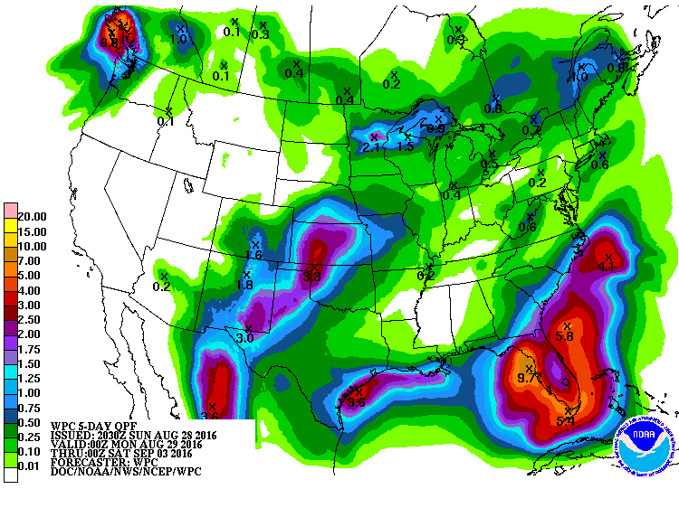
In the near term, heavy tropical rain is likely to occur over much of the Florida Peninsula with amounts of 3 to 5 inches. The HPC folks are estimating the heaviest rainfall over the next five days to fall in the eastern Gulf of Mexico with 7 to 10 inches possible.
It always seems to get exciting as we approach the peak in hurricane season, and 2016 is certainly not disappointing.
-Brian-
Category: Alabama's Weather, Tropical
About the Author (Author Profile)
Brian Peters is one of the television meteorologists at ABC3340 in Birmingham and a retired NWS Warning Coordination Meteorologist. He handles the weekend Weather Xtreme Videos and forecast discussion and is the Webmaster for the popular WeatherBrains podcast.Subscribe
If you enjoyed this article, subscribe to receive more just like it.


