

Watching TD 9; Mostly Dry For Alabama
SHOWERS WILL BE HARD TO FIND THIS WEEK: The upper ridge is holding across Alabama and the Deep South, meaning the weather won’t change much through mid-week. Mostly sunny, hot, humid days with only isolated afternoon and evening showers; chance of any one spot getting wet today, tomorrow, and Wednesday is only about one in eight. Highs will be in the 91-95 degree range.
LATER THIS WEEK: An upper trough will pass north of Alabama, beating down the ridge, and allowing drier air to drop in from the north. Showers look very unlikely with the change, but at least dew points will come down by Friday with lower humidity during the day, and slightly cooler nights. The high Thursday will be in the low 90s, and some spots just might hold below 90 degrees Friday with that airmass change.
LABOR DAY WEEKEND: Dry air stays in place; we expect mostly sunny days and fair nights Saturday through Monday. While highs will be close to 90 degrees, nights will be cooler thanks to the dry air; we project low to mid 60s early Saturday morning, with potential for upper 50s for some of the normally cooler spots.
And, the dry pattern continues well into next week. See the Weather Xtreme video for maps, graphics, and more details.
FOOTBALL WEATHER: First off, Friday night looks fantastic for high school football across Alabama with a clear sky and temperatures falling through the 70s. Humidity levels won’t be as bad as the first two weeks.
Auburn hosts Clemson Saturday night at Jordan-Hare Stadium (8:00p CT kickoff)… the sky will be clear. Kickoff temperature near 78 degrees, falling into the low 70s by the final whistle.
Alabama will take on Southern Cal Saturday night at Arlington, Texas (8:00p CT kickoff)… a clear sky with temperatures falling from near 82 at kickoff, into the mid 70s by the end of the game.
TROPICS: Three systems are on the board; Hurricane Gaston is in the Central Atlantic, and is recurving well east of Bermuda, and is no threat to land.
Tropical Depression Eight is struggling this morning with hardly any convection; it has potential to become a weak tropical storm, and should recurve into the Atlantic just off the Outer Banks of North Carolina.
And, our old friend “Invest 99L” is now Tropical Depression Nine in the southeast Gulf of Mexico. Here are the important points to note…
*The system remains very disorganized this morning. Some chance it reaches tropical storm strength, but it is not expected to become a hurricane.
*The NHC track has the center turning northeast over the Gulf of Mexico, cutting across North Florida Thursday. Not too important to focus on the center since this will, most likely, still be pretty disorganized.
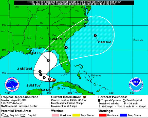
*TD 9 will have no direct impact on Alabama, although it will help to pull down drier air late this week.
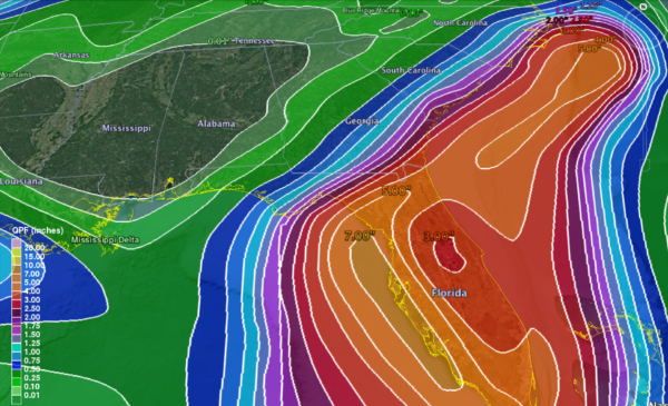
*The main issue with the system is rain for the Florida Peninsula (not the panhandle), and dangerous surf/rip tides. Most of the rain over the Florida Peninsula will fall today through Thursday. The rain won’t be continuous, however, and the sun will be out at times.
*TD 9 will be long gone by the Labor Day weekend; nothing but the routine risk of “widely scattered thunderstorms” for Florida with a good supply of sunshine by then. Even for places like Orlando, Tampa, and Daytona Beach.
GULF COAST WEATHER: Generally speaking, the weather looks fine on the Central Gulf Coast (Gulf Shores east to Panama City Beach) this weekend, and over the holiday weekend with 7 to 9 hours of sunshine daily and only widely scattered showers. The exception will be at Panama City Beach Thursday as TD 9 passes just to the south… periods of rain are likely on that one day. And, also keep in mind there will be potential for rip tides along the coast this week, especially tomorrow, Wednesday, and Thursday. But, the surf will settle down for the weekend. Highs on the immediate coast will be in the upper 80s, with low 90s inland. See a very detailed Gulf Coast forecast here.
ON THIS DAY IN 2005: Hurricane Katrina made landfall in Plaquemines Parish in southeastern Louisiana early on the day with maximum sustained winds near 125 mph, a strong category-three, and the third most-intense landfalling hurricane in U.S. history. The center of the hurricane passed just east of New Orleans, where winds gusted over 100 mph. Widespread devastation and unprecedented flooding occurred, submerging at least 80 percent of the city as levees failed. Farther east, powerful winds and a devastating storm surge of 20-30 feet raked the Mississippi coastline, including Gulfport and Biloxi, where Gulf of Mexico floodwaters spread several miles inland. Rainfall amounts of 8-10 inches were common along and to the east of the storm’s path.
WEATHER BRAINS: Don’t forget you can listen to our weekly 90 minute netcast anytime on the web, or on iTunes. This is the show all about weather featuring many familiar voices, including our meteorologists here at ABC 33/40. We will produce this week’s show tonight at 8:30 CT… you can watch it live here.
CONNECT: You can find me on all of the major social networks…
Facebook
Twitter
Google Plus
Instagram
Look for the next Weather Xtreme video here by 4:00 this afternoon… enjoy the day!
Category: Alabama's Weather
About the Author (Author Profile)
James Spann is one of the most recognized and trusted television meteorologists in the industry. He holds the AMS CCM designation and television seals from the AMS and NWA. He is a past winner of the Broadcast Meteorologist of the Year from both professional organizations.Subscribe
If you enjoyed this article, subscribe to receive more just like it.


