

TD9 To Be Upgraded Soon; Alabama Mostly Dry
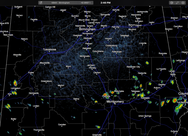
RADAR CHECK: As expected, showers are pretty hard to find across Alabama this afternoon… most of them are around the U.S. 80 corridor… moving to the west…
Temperatures are mostly in the low 90s.
TOMORROW/THURSDAY: No real change; mostly sunny, hot days with highs in the 91-95 degree range; the chance of any one spot getting wet is only about one in eight. Showers will stay few and far between.
FRIDAY AND THE HOLIDAY WEEKEND: Drier, continental air will move into Alabama Friday, setting up a pretty nice Labor Day weekend. We expect mostly sunny days, lower humidity, and fair cooler nights. Highs 87-91; lows down in the 60s. In fact, some of the normally cooler spots could reach the upper 50s early Sunday morning for a little fall preview.
Dry weather will most likely continue into the middle of next week; see the Weather Xtreme video for maps, graphics, and more details.
TOPIC: TROPICS: Quite a smorgasbord today… let’s take it one system at a time.
HURRICANE GASTON: Estimated winds are at 105 mph; Gaston is moving east in the open Atlantic. It could impact the Azores this weekend as a weakening system, but otherwise no impact to land.
INVEST 92L: The new wave in the far eastern Atlantic remains disorganized, but a pretty good chance it becomes better organized later this week on the journey westward. Models for now take this one north of the Caribbean, suggesting it won’t be a Gulf of Mexico threat, but it is simply way too early to know for sure. Just something to watch for now.
TROPICAL DEPRESSION EIGHT: The system just east of the North Carolina Outer Banks remains disorganized. It will move out to sea tomorrow, and the Labor Day weekend looks great for the Atlantic coast.
TROPICAL DEPRESSION NINE: The TD in the Gulf of Mexico looks better organized, and it will probably be upgraded to Tropical Storm Hermine soon. Not much change in thinking; it will move into North Florida Thursday evening…
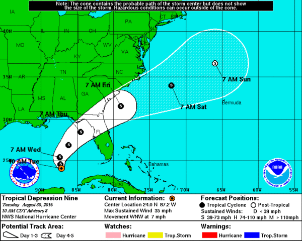
The main issue will be heavy rain across the Florida Peninsula; amounts of over 5 inches are likely. Also, dangerous surf and rip tides are likely as far west as Dauphin Island over the next 48 hours. The good news is that this system will move over into the Atlantic Friday, and will be long gone by the Labor Day weekend.
IMPACT ON THE CENTRAL GULF COAST: The main issue will be around Panama City Beach, and perhaps as far east as Destin on Thursday, when winds will increase as the tropical system gets closer. A few periods of rain are likely Thursday as well from Destin east. Also, note that dangerous rip tides are likely along the coastline from Gulf Shores to Panama City Beach through Thursday with red flags up already this afternoon.
The tropical system will be long gone by the Labor Day weekend; we project sunny days and fair nights Friday through Monday with only isolated showers. Highs on the immediate coast 87-90, with low 90s inland. See a very detailed Gulf Coast forecast here.
FOOTBALL WEATHER: Friday night looks fantastic for high school football across Alabama with a clear sky and temperatures falling through the 70s. Humidity levels won’t be as bad as the first two weeks.
Auburn hosts Clemson Saturday night at Jordan-Hare Stadium (8:00p CT kickoff)… the sky will be clear. Kickoff temperature near 78 degrees, falling into the low 70s by the final whistle.
Alabama will take on Southern Cal Saturday night at Arlington, Texas (8:00p CT kickoff)… a clear sky with temperatures falling from near 82 at kickoff, into the mid 70s by the end of the game.
WEATHER BRAINS: Don’t forget you can listen to our weekly 90 minute netcast anytime on the web, or on iTunes. This is the show all about weather featuring many familiar voices, including our meteorologists here at ABC 33/40.
CONNECT: You can find me on all of the major social networks…
Facebook
Twitter
Google Plus
Instagram
I had a great time today visiting with the students at Glen Iris Baptist School in Birmingham… be looking for them on the Pepsi KIDCAM today at 5:00 on ABC 33/40 News! The next Weather Xtreme video will be posted early tomorrow morning by 7:00…
Category: Alabama's Weather
About the Author (Author Profile)
James Spann is one of the most recognized and trusted television meteorologists in the industry. He holds the AMS CCM designation and television seals from the AMS and NWA. He is a past winner of the Broadcast Meteorologist of the Year from both professional organizations.Subscribe
If you enjoyed this article, subscribe to receive more just like it.


