

TD 9 – Gulf Coast Impact
This is a look at expected impact of Tropical Depression Nine on Florida and the Gulf Coast…
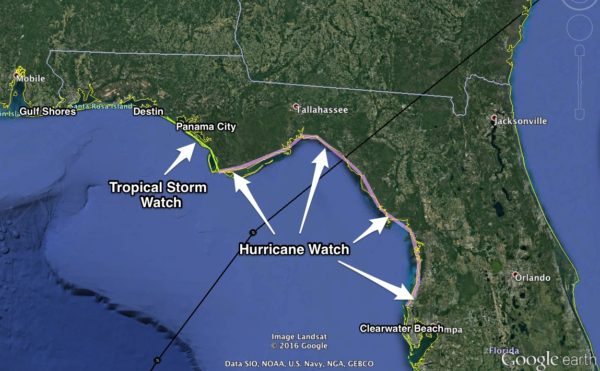
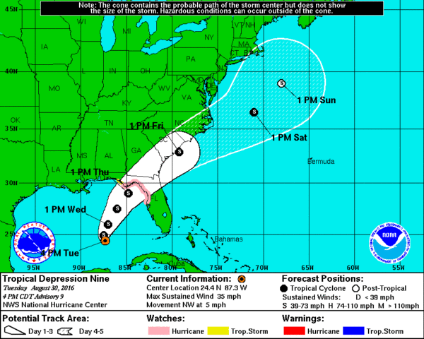
TD 9 should become a tropical storm tonight (most likely getting the name “Hermine”). The center of circulation should move into North Florida east of Apalachicola Thursday afternoon. While this system is not expected to become a hurricane, some model guidance is suggesting it will be a high end tropical storm, with potential for winds of 50 mph or higher. Accordingly, a Hurricane Watch has been issued from the Anclote River to Indian Pass. And a Tropical Storm Watch has been issued for the Florida Gulf Coast west of Indian Pass to the Walton/Bay County line.
Here are the important impact points…
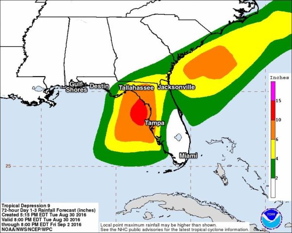
*Heaviest rain will come over North Florida tomorrow and Thursday, mainly east of a line from Marianna to Panama City Beach. Some spots could see over 5 inches of rain, and flooding is a very real possibility, and most likely will be the biggest impact from the system.
*Dangerous surf and rip tides are likely on the Central Gulf Coast all the way from Gulf Shores to Apalachicola and all the way down to Tampa through Thursday. Red flags are flying now.
*An isolated tornado or two will be possible Thursday over North Florida, especially in the corridor from Cross City to Jacksonville.
*There could enough gradient wind to knock down some trees and power lines over North Florida… places like Tallahassee, Cedar Key, Lake City, and Ocala.
*The tropical system moves over to the Atlantic coast Friday, and conditions will improve dramatically in Florida. The Labor Day weekend for all of Florida looks nice, with ample sunshine and only a few widely scattered showers or storms. Seas will subside as well by Saturday.
*The weather actually looks very nice for Dauphin Island, Gulf Shores, and Pensacola all the way through the holiday weekend, with mostly sunny days and fair nights… only widely scattered storms. It will be breezy Thursday, and again we stress that dangerous rip tides are likely through Thursday night. The seas will calm down by the Labor Day weekend.
Stay tuned to the blog for updates in coming days…
Category: Alabama's Weather
About the Author (Author Profile)
James Spann is one of the most recognized and trusted television meteorologists in the industry. He holds the AMS CCM designation and television seals from the AMS and NWA. He is a past winner of the Broadcast Meteorologist of the Year from both professional organizations.Subscribe
If you enjoyed this article, subscribe to receive more just like it.


