

Eyes On The Gulf of Mexico; Dry Around Here
DRY PATTERN FOR MOST OF ALABAMA: Despite the much discussed tropical mischief, showers will remain hard to find across Alabama for the next five to seven days. A few isolated afternoon and evening showers are possible today and tomorrow, but the chance of any one spot getting wet is only about one in ten. Expect lots of sunshine, and we stay hot with mid 90s likely.
FRIDAY AND THE HOLIDAY WEEKEND: The tropical system passes east of Alabama, and will help to pull down drier air into the state. This will mean mostly sunny days, fair cooler nights, and lower humidity on these four days. Highs drop back into the 87-90 degree range, with lows generally in the 60s. And, the dry weather will likely linger into at least the middle of next week.
ACTIVE TROPICS: Let’s take it one system at a time…
GASTON: This is now a major hurricane with sustained winds of 120 mph (category three), but it is in the middle of the Atlantic, moving away from the U.S. It could impact the Azores this weekend as a weakening system.
EASTERN ATLANTIC WAVE: A wave near the Cape Verde Islands bears watching over the next seven days as it journeys westward across the Atlantic. A decent chance this develops over the weekend; remains to be seen if it will be any threat to the U.S. Just something to watch for now.
TD EIGHT: The depression east of North Carolina is still having a hard time getting its act together. It is moving away from the U.S. and still has a chance of becoming a tropical storm on the journey out to sea.
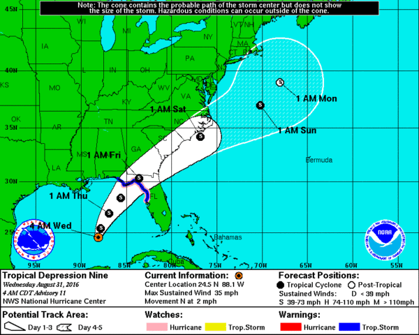
TD NINE: This is our “backyard” tropical system in the southern Gulf of Mexico. Convection has been steadily increasing over the past 24 hours, and there is a high chance this becomes a tropical storm later this morning (most likely, it will get the name “Hermine”). Here are the important things you need to know…
*This will not directly impact most of Alabama. It will be breezy down around Dothan Thursday night with showers possible, but the rest of the state will stay in a pretty dry pattern.
*A Tropical Storm Warning has been issued for the Gulf coast of Florida from Anclote River to the Walton/Bay County Line. A Hurricane Watch remains in effect from Anclote River to Indian Pass; this was issued yesterday since the tropical storm could be close to hurricane strength at the time of landfall.
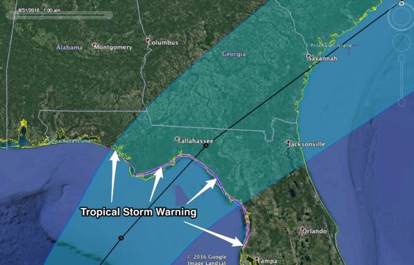
*The circulation center should move inland tomorrow night near or east of Apalachicola. The main impacts will be along and to the right of the landfall point (to the south and east).
*Rain amounts could exceed five inches over parts of North Florida, mainly east of a line from Marianna to Panama City Beach. Flooding is a very real possibility in spots.
*There is a possibility of storm surge inundation within the next 48 hours along the Gulf coast of Florida from Aripeka to Indian Pass. This is well east of Panama City Beach.
*Dangerous rip tides are likely all the way from Gulf Shores down to Fort Myers Beach through Friday. Many beaches already have double red flags flying.
*A few isolated tornadoes are possible across North Florida tomorrow and tomorrow night.
*This system will move northeast, and will impact the Atlantic coast over the Labor Day weekend; it should be near Cape Hatteras Saturday.
GULF SHORES TO PANAMA CITY BEACH: Many are planning a beach trip for the holiday weekend, and we stress this system will be long gone by Friday with fine weather and calmer seas. Dauphin Island, Gulf Shores, Pensacola Beach, and Navarre Beach will see only widely scattered showers or storms today and tomorrow; best chance of rain from the tropical system will come tomorrow at Destin and Panama City Beach, but thankfully they will be on the drier side of the circulation. See a very detailed Gulf Coast forecast here.
FOOTBALL WEATHER: Friday night looks fantastic for high school football across Alabama with a clear sky and temperatures falling through the 70s. Humidity levels won’t be as bad as the first two weeks.
Auburn hosts Clemson Saturday night at Jordan-Hare Stadium (8:00p CT kickoff)… the sky will be clear. Kickoff temperature near 76 degrees, falling into the low 70s by the final whistle.
Alabama will take on Southern Cal Saturday night at Arlington, Texas (8:00p CT kickoff)… a clear sky with temperatures falling from near 82 at kickoff, into the mid 70s by the end of the game.
WEATHER BRAINS: Don’t forget you can listen to our weekly 90 minute netcast anytime on the web, or on iTunes. This is the show all about weather featuring many familiar voices, including our meteorologists here at ABC 33/40.
CONNECT: You can find me on all of the major social networks…
Facebook
Twitter
Google Plus
Instagram
Look for the next Weather Xtreme video here by 4:00 this afternoon… enjoy the day!
Category: Alabama's Weather
About the Author (Author Profile)
James Spann is one of the most recognized and trusted television meteorologists in the industry. He holds the AMS CCM designation and television seals from the AMS and NWA. He is a past winner of the Broadcast Meteorologist of the Year from both professional organizations.Subscribe
If you enjoyed this article, subscribe to receive more just like it.


