

Midday Nowcast: All Quiet Here, Just Hot & Humid. TD9 Is Still A Depression
Hot and humid conditions out there at this hour for Central Alabama, with mostly clear skies and all quiet on radar at this moment. And once again, all eyes are on the Gulf of Mexico to see if Tropical Depression Nine will finally strengthen into a tropical storm. Details on the system are below.
TEMPERATURES AT THIS HOUR: Here is a list of temperature observations from across the area at this hour:
Birmingham 91
Tuscaloosa 91
Gadsden 90
Anniston 90
Cullman 89
Jasper 95
Alexander City 90
Selma 88
Montgomery 90
CODE YELLOW AIR QUALITY: The Air Quality Index for the Birmingham Metropolitan Area is in the “Code Yellow” for ozone and particulate matter 2.5. Unusually sensitive people should consider limiting prolonged outdoor exertion.
TODAY’S CLIMATOLOGY FOR BIRMINGHAM: The normal high for August 31st is 88, while the normal low is 67. The record high for today was set back in 1951 at 100. The record low was set back in 1946 at 51.
REMAINDER OF TODAY: Even though there is tropical mischief nearby, the forecast pretty much remains the same… hot and humid, with partly to mostly clear skies, and with a very slight chance of widely scattered afternoon and evening showers and thunderstorms. Afternoon highs will mostly be in the mid 90s. The odds of any one spot getting rain is about one in ten.
THURSDAY’S WEATHER: Same as today… hot and humid, with a mix of sun and clouds. Afternoon highs in the mid 90s, with a one in ten chance of isolated showers and thunderstorms, mainly during the afternoon and evening hours.
HEADED TO THE BEACH: Many are planning a beach trip for the holiday weekend, and we stress this system will be long gone by Friday with fine weather and calmer seas. Dauphin Island, Gulf Shores, Pensacola Beach, and Navarre Beach will see only widely scattered showers or storms today and tomorrow; best chance of rain from the tropical system will come tomorrow at Destin and Panama City Beach, but thankfully they will be on the drier side of the circulation. See a very detailed Gulf Coast forecast here.
TROPICAL DEPRESSION NINE: As of now, deep convection is being produced by TD9, but there is little overall cloud pattern organization. This means that there has been little change in strength and is still with 35 MPH maximum sustained winds. Over the next 36 hours, TD9 will be over very warm water and in a moderate shear environment. Strengthening is expected to occur and is expected to be a tropical storm when it makes landfall near or east of Apalachicola tomorrow evening. The main impacts will be along and to the right of the landfall point. It will move northeast and impact the Atlantic Coast over the Labor Day weekend. It should be near Cape Hatteras on Saturday.
Rain amounts could exceed five inches over parts of North Florida, especially east of Marianna to Panama City Beach. Flooding is a very real possibility in spots. There is a possibility of storm surge inundation along the Gulf Coast of Florida from Aripeka to Indian Pass within the next 48 hours (this will be east of Panama City Beach). Dangerous rip tides are likely from Gulf Shores down to Fort Myers Beach through Friday, with many beaches already flying double red flags. A few isolated tornadoes are possible across North Florida tomorrow and tomorrow night.
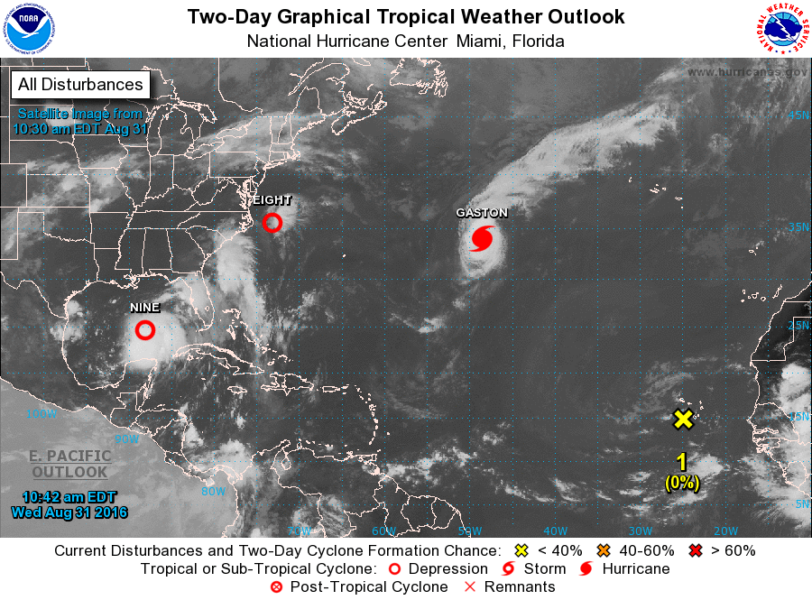
REST OF THE TROPICS: Hurricane Gaston is continuing to move east-northeastward at 15 MPH, away from the U.S. Still packing maximum sustained winds at 115 MPH, it will be close to the Azores this weekend as a “post tropical” North Atlantic storm. Tropical Depression Eight is a disorganized system east of North Carolina. It is moving away from the U.S. and still has a chance of becoming a tropical storm on its journey out to sea. A tropical wave that is near the Cape Verde Islands bears watching over the next seven days as it journeys westward across the Atlantic. A decent chance this develops over the weekend; remains to be seen if it will be any threat to the U.S. Just something to watch for now.
ON THIS DAY IN 1987: Eight cities in Washington and Oregon reported record high temperatures for the date, including Eugene OR and Portland OR with afternoon highs of 102 degrees. The high of 102 degrees at Portland smashed their previous record for the date by twelve degrees. Frost was reported in South Dakota. Aberdeen SD established a record for the month of August with a morning low of 32 degrees, and Britton SD dipped to 31 degrees.
THE BLOG IS ON TWITTER: Be sure to follow the Alabama Wx Weather Blog on Twitter. Just click here to start following our feed.
WEATHERBRAINS: This is the show all about weather featuring many familiar voices, including our meteorologists at ABC 33/40. You can listen anytime on the web, or on iTunes. You can find it here.
ADVERTISE WITH US: Deliver your message to a highly engaged audience by advertising on the AlabamaWX.com website. The site enjoyed 10.2 MILLION pageviews in the past 12 months. Don’t miss out! We can customize a creative, flexible and affordable package that will suit your organization’s needs. Contact Bill Murray at (205) 687-0782.
Category: Alabama's Weather
About the Author (Author Profile)
Scott Martin is an operational meteorologist, professional graphic artist, musician, husband, and father. Not only is Scott a member of the National Weather Association, but he is also the Central Alabama Chapter of the NWA president. Scott is also the co-founder of Racecast Weather, which provides forecasts for many racing series across the USA. He also supplies forecasts for the BassMaster Elite Series events including the BassMaster Classic.Subscribe
If you enjoyed this article, subscribe to receive more just like it.


