

Warm; Isolated Showers Sunday
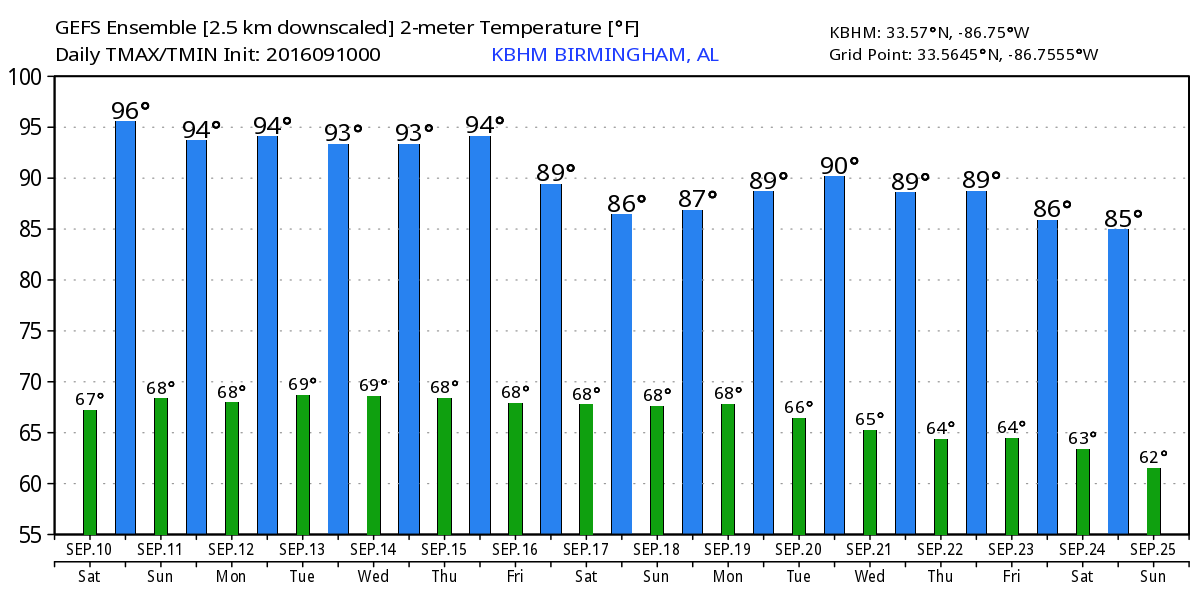
Starting the day off with mostly clear skies and temperatures generally in the 60s. We should see a mostly sunny day as we watch a weakening cold front approach the area from the northwest. Highs will be warm once again as highs reach the lower 90s.
Looking at college football weather, Alabama hosts Western Kentucky this afternoon at Bryant-Denny Stadium for the 2016 home opener with a kickoff at 2:30 pm CDT. The sky will be mainly sunny with 92 degrees at kickoff dropping back into the upper 80s by the end of the game. Auburn will host Arkansas State at Jordan Hare Stadium this evening with a 6:30 pm CDT kickoff. The sky will be fair with temperatures falling from 86 degrees at kickoff into the upper 70s by the fourth quarter.
Weather at the beach looks fairly nice with mostly sunny days, fair nights, and only isolated storms on the coast through the weekend. There could be a passing storm, but overall fairly dry conditions. Highs will be in the upper 80s along the immediate coast with low 90s inland. The sea water temperature at the Dauphin Island Sea Lab was a warm 84.8 degrees. See the complete Gulf Coast 7 Day Planner here.
SPC has outlooked an area of slight risk for severe weather along and just ahead of the front from Central Kentucky northeast into the eastern Great Lakes area. No slight risk areas are forecast for Days 2 and 3.
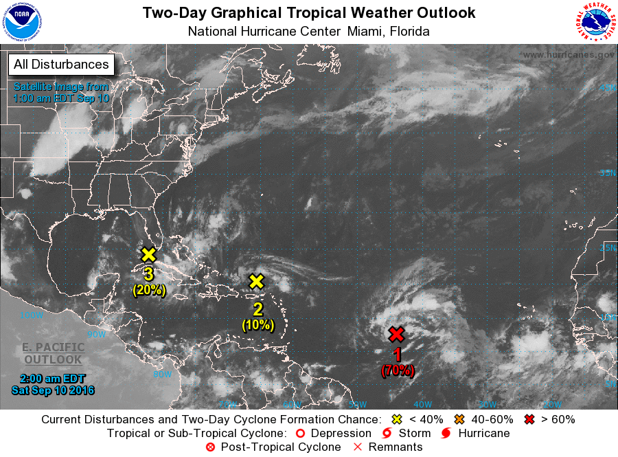
Tropics are once again active with three areas under the watchful eye of hurricane forecasters. The first one in the Central Atlantic appears to have the best chance to develop, and it is forecast to recurve and remain in the Central Atlantic. The second area is just north of Puerto Rico and should continue northwesterly with little likelihood for development. The third area is in the Florida Straits and will be moving into the Gulf. Upper level winds remain unfavorable for this system to do much as it traverses the Gulf on a course toward extreme South Texas.
Because I’m i the eastern time zone, I’m using the 00Z GFS run this morning for the discussion. The upper trough approaching the eastern US today will zip across the Great Lakes tonight and be located over New England on Sunday afternoon. The cold front will drag into the Southeast US and weaken or wash out on Sunday. The presence of the frontal boundary a potential for an isolated storm or two.
The front washes out late Sunday and into Monday leaving a small chance for an isolated storm or two. We won’t see a big change in our highs they remain around 90.
The ridge builds back into the Southeast US on Tuesday and becomes the main player in our weather pattern through the end of the week. The GFS is suggesting the ridge could be the strongest on Thursday and Friday with the potential for highs to be in the 93 to 95 range as the heat sticks with us.
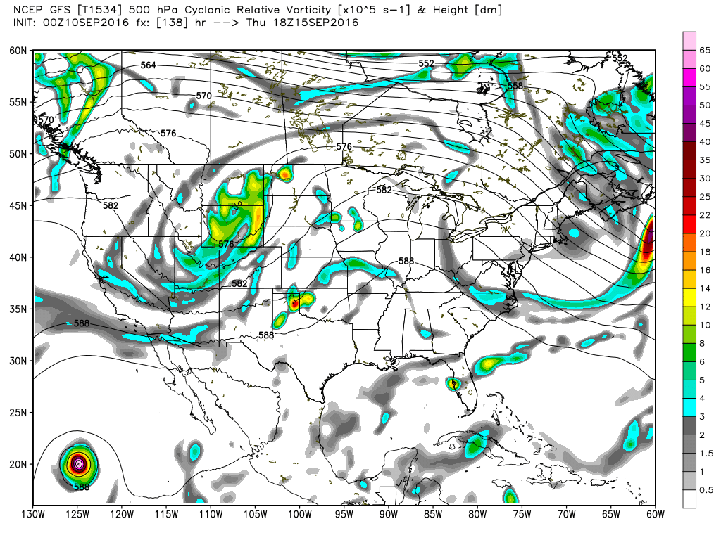
A strong trough coming out of the Rockies on Saturday will bring the approach of another cold front. Moisture also increases as the surface flow comes around to the south. Additional clouds along with a bit better chance for showers will help to keep highs in the upper 80s.
With the use of the 00Z GFS, I don’t have much to look at into voodoo country.
I’m in Norfolk, VA, this morning getting ready to work as a volunteer at the WeatherFest event that is a part of the National Weather Associations annual weather conference. We’re featuring meteorology at the Nauticus today. The free event is expected to draw over 3,000 people. I will have the next Weather Xtreme Video on Sunday morning, but it may not get posted until a little bit later in the morning.
-Brian-
Category: Alabama's Weather
About the Author (Author Profile)
Brian Peters is one of the television meteorologists at ABC3340 in Birmingham and a retired NWS Warning Coordination Meteorologist. He handles the weekend Weather Xtreme Videos and forecast discussion and is the Webmaster for the popular WeatherBrains podcast.Subscribe
If you enjoyed this article, subscribe to receive more just like it.


