

Scattered Storms Daily Through Friday
RADAR CHECK: A surface front bisects Alabama this afternoon; the northern counties of the state are in dry air, and we see no rain along and north of I-20. South of the front thunderstorms with heavy rain and lots of lightning are scattered across South Alabama.
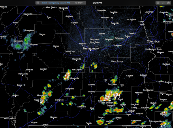
Temperatures are generally in the upper 80s with a mix of sun and clouds.
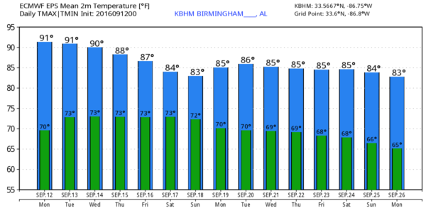
REST OF THE WEEK: The front across Central Alabama will dissipate, and moist air moves northward. Accordingly, we will mention some risk of scattered showers and storms daily, mostly during the afternoon and evening hours. The chance of any one spot getting wet each day will be about one in four. Otherwise, partly sunny days with highs between 86 and 90 degrees for most places. Early morning lows will be mostly in the low 70s.
THE WEEKEND: The upper ridge weakens a bit, and with the approach of a surface front, scattered storms should be a little more active across the state Saturday and Sunday. Expect a mix of sun and clouds both days, and the best chance of showers and storms will come from about 2:00 until 9:00 p.m. Highs will be in the mid to upper 80s.
FOOTBALL WEATHER: Auburn will host Texas A&M Saturday evening at Jordan-Hare Stadium (6:30p CT kickoff)… a shower or thunderstorm will be possible during the game with a mostly cloudy sky. Temperatures will fall from near 84 degrees at kickoff, into the upper 70s by the final whistle.
Alabama travels to Oxford to play Ole Miss Saturday (2:30p CT kickoff). The sky will be mostly cloudy, and a passing shower or storm is likely during the game. Temperatures will hover in the mid 80s.
NEXT WEEK: Drier air will try and work into North Alabama with the best chance of scattered storms shifting down into the southern counties of the state. Highs will be generally in the 80s… see the Weather Xtreme video for maps, graphics, and more details.
TROPICS: Tropical Storm Ian has formed in the Central Atlantic today, but it will move northward over open water, and is no threat to land. Over in the western Pacific, Super Typhoon Meranti will approach Taiwan later this week with flooding rain and damaging winds.
AT THE BEACH: About 7 to 9 hours of sunshine on the Gulf Coast (Panama City Beach over to Gulf Shores) this week with a few scattered storms. Highs in the upper 80s on the immediate coast, with low 90s inland. See a very detailed Gulf Coast forecast here.
WEATHER ON THIS DATE IN 1979: Hurricane Frederic smashed into Mobile Bay packing 125 mph plus winds. Winds gusts to 145 mph were reported as the eye of the hurricane moved over Dauphin Island. Frederick produced a fifteen foot storm surge near the mouth of Mobile Bay. The hurricane was the costliest in U.S. history at the time, causing 2.3 billion dollars damage.
WEATHER BRAINS: Don’t forget you can listen to our weekly 90 minute netcast anytime on the web, or on iTunes. This is the show all about weather featuring many familiar voices, including our meteorologists here at ABC 33/40. We will produce this week’s show tonight at 8:30 CT… you can watch it live here.
CONNECT: You can find me on all of the major social networks…
Facebook
Twitter
Google Plus
Instagram
Look for the next Weather Xtreme video here by 7:00 a.m. tomorrow…
Category: Alabama's Weather
About the Author (Author Profile)
James Spann is one of the most recognized and trusted television meteorologists in the industry. He holds the AMS CCM designation and television seals from the AMS and NWA. He is a past winner of the Broadcast Meteorologist of the Year from both professional organizations.Subscribe
If you enjoyed this article, subscribe to receive more just like it.


