

No Widespread Rain Here Anytime Soon
**No afternoon Weather Xtreme video today; I am speaking at a weather function in Minnesota… I return home tomorrow**
RADAR CHECK: Showers have been almost impossible to find across Alabama this afternoon, and unfortunately with Tropical Storm Julia to the east, we are on the “dry side” of the storm, and prospects for a good rain look small through the weekend. Expect partly to mostly sunny days and fair nights through Friday with only isolated afternoon and evening showers. Chance of any one spot getting wet each day is only about one in ten. And, we will to bump afternoon highs up into the 91-94 degree range.
THE WEEKEND: Initially we expected an increase in the number of scattered showers and storms Saturday and Sunday, but the latest model data continues to come in drier. We will still hang on to some risk of widely scattered afternoon/evening showers, but it sure looks like most of the weekend will be dry with highs pretty close to 90 degrees. The sky will stay partly to mostly sunny.
FOOTBALL WEATHER: Mostly fair weather for the high school games across Alabama Friday night with only a very small risk of a shower around kickoff. Temperatures will fall through the 80s.
Auburn will host Texas A&M Saturday evening at Jordan-Hare Stadium (6:30p CT kickoff)… looks like a great night for football; the sky will be mostly fair with only a slight risk of a shower during the first half. Temperatures will fall from near 86 degrees at kickoff, to near 80 by the final whistle.
Alabama travels to Oxford to play Ole Miss Saturday (2:30p CT kickoff). The sky will be partly sunny, and a passing shower or storm is possible during the game, but not likely. Temperatures will hover in the 87 to 90 degree range.
NEXT WEEK: Same story. Any showers look few and far between through the week as the upper ridge holds across the Deep South. Highs around 90 degrees with a good supply of sunshine each day.
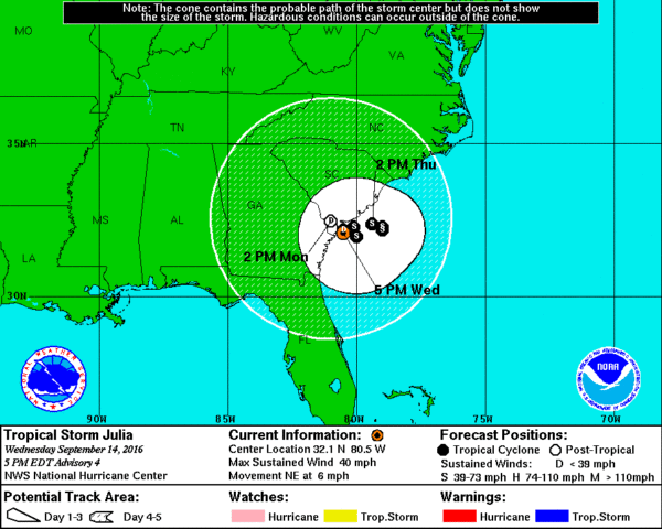
TROPICAL STORM JULIA: The storm is packing sustained winds of 40 mph, and is centered just east of Savannah, Georgia. It won’t move much over the next 3 to 5 days with very weak steering currents; main issue will be potential for heavy rain and flooding on the South Carolina coast.
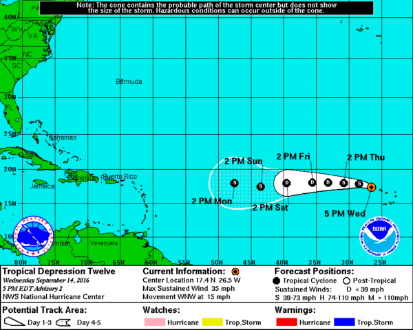
TROPICAL DEPRESSION 12: A new depression has formed in the eastern Atlantic, just west of the Cape Verde Islands. It will move westward across open water in coming days, and could be upgraded to Tropical Storm Karl at some point. Remains to be seen if this will be a threat to the U.S. or any land mass…
AT THE BEACH: About 7 to 9 hours of sunshine daily on the Gulf Coast from Panama City Beach to Gulf Shores through the weekend, with the usual chance of scattered showers and thunderstorms. Highs on the immediate coast will be in the upper 80s, with low 90s inland. See a very detailed Gulf Coast forecast here.
WEATHER BRAINS: Don’t forget you can listen to our weekly 90 minute netcast anytime on the web, or on iTunes. This is the show all about weather featuring many familiar voices, including our meteorologists here at ABC 33/40.c
CONNECT: You can find me on all of the major social networks…
Facebook
Twitter
Google Plus
Instagram
Look for the next Weather Xtreme video here by 7:00 a.m. tomorrow…
Category: Alabama's Weather
About the Author (Author Profile)
James Spann is one of the most recognized and trusted television meteorologists in the industry. He holds the AMS CCM designation and television seals from the AMS and NWA. He is a past winner of the Broadcast Meteorologist of the Year from both professional organizations.Subscribe
If you enjoyed this article, subscribe to receive more just like it.


