

Showers/Storms Increase Sunday
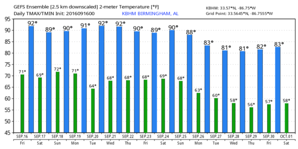
HOT FOR SEPTEMBER: Yesterday’s official high in Birmingham was 98 degrees… 13 degrees above average for September 15, and within 4 degrees of the record high of 102, set in 1927. The upper ridge holds today, and we will be in the 90s again; today’s high should be in the 92-95 degree range. The sky will be partly sunny, and like yesterday a few widely scattered showers or storms could form during the peak of the heat.
THE WEEKEND: The ridge will weaken slightly, but showers and storms tomorrow afternoon should remain widely scattered across Alabama with a high between 88 and 91 degrees. Chance of any one spot getting wet tomorrow afternoon is one in four, and the sky will be partly sunny.
It sure seems like Sunday will offer the best chance of getting rain for most places as a surface front approaches from the north. The sky will be occasionally cloudy with scattered to numerous showers and thunderstorms. We can’t promise rain for everybody, but this will be the best chance out of the next seven days. We won’t get out of the 80s because of clouds and showers.
FOOTBALL WEATHER: Mostly fair weather for the high school games across Alabama tonight with only a small risk of a shower around kickoff. Temperatures will fall through the 80s.
Auburn will host Texas A&M Saturday evening at Jordan-Hare Stadium (6:30p CT kickoff)… we can’t totally rule out a shower or storm during the first half, otherwise the sky will be mostly fair with temperatures falling from near 86 degrees at kickoff into the upper 70s by the fourth quarter.
Alabama travels to Oxford to play Ole Miss Saturday (2:30p CT kickoff). The sky will be partly sunny, and a passing shower or storm is very possible during the game. Temperatures will hover in the mid to upper 80s, and humidity levels will be high.
NEXT WEEK: Drier air moves into the state Monday, and the weather looks generally dry through Wednesday with mostly sunny days, fair nights, and highs close to 90 degrees. The chance of widely scattered showers or storms will return later in the week… see the Weather Xtreme video for maps, graphics, and more details.
LONG RANGE: Still seeing signs of a pattern change late in the month that will finally bring down some cooler air into the Deep South.
TROPICS: We have three ongoing tropical storms in the Atlantic basin…
JULIA: This is a weak tropical storm off the coast of South Carolina; it will be milling around in pretty much the same spot for several days, and should begin to dissipate next week. It will remain far enough offshore to prevent any serious impact on the South Atlantic coast other than rough surf.
IAN: This is a high latitude system in the Atlantic that will become post-tropical over the next 24 hours. No threat to land.
KARL: This is the newest system on the board in the eastern Atlantic; it will move to the west/northwest over the next five days, and is expected to become a hurricane early next week. But, long range model guidance suggests this will recurve, and won’t be a threat to the U.S.
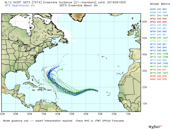
A new wave is coming off the coast of Africa, with potential for development in coming days, and a weak disturbance in the western Gulf of Mexico will move into Texas tonight.
AT THE BEACH: About 7 to 9 hours of sunshine on the Gulf Coast from Gulf Shores to Panama City Beach through the weekend with just a few widely scattered storms. Highs in the upper 80s on the immediate coast, with low 90s inland. See a very detailed Gulf Coast forecast here.
WEATHER BRAINS: Don’t forget you can listen to our weekly 90 minute netcast anytime on the web, or on iTunes. This is the show all about weather featuring many familiar voices, including our meteorologists here at ABC 33/40.
CONNECT: You can find me on all of the major social networks…
Facebook
Twitter
Google Plus
Instagram
I will be doing a weather program this morning at DeArmanville School in Calhoun County… look for the next Weather Xtreme video here by 4:00 this afternoon… enjoy the day!
Category: Alabama's Weather
About the Author (Author Profile)
James Spann is one of the most recognized and trusted television meteorologists in the industry. He holds the AMS CCM designation and television seals from the AMS and NWA. He is a past winner of the Broadcast Meteorologist of the Year from both professional organizations.Subscribe
If you enjoyed this article, subscribe to receive more just like it.


