

Dry Pattern For Most Of Alabama
FALL ARRIVES THIS WEEK: The autumnal equinox is Thursday (September 21) at 9:21 a.m…. when the sun is directly over the equator and we have approximately 12 hours of daylight and 12 hours of darkness. And, fall arrives this week with a rather quiet weather pattern for most of Alabama.
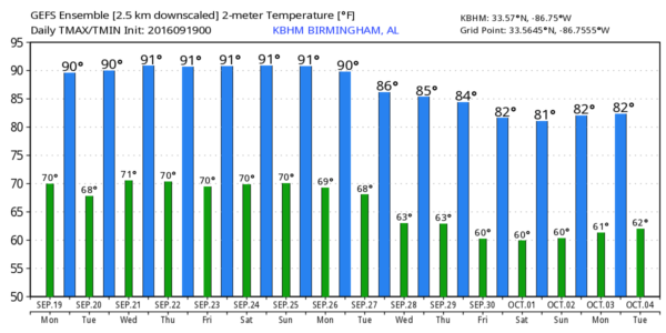
At Birmingham-Shuttlesworth International Airport, yesterday’s rain total was about 1/3 of an inch (0.32″), bringing the total for the month to 0.68″. Unfortunately, additional rain is very unlikely this week as a dry airmass settles into the state. We will project mostly sunny days and fair nights through Friday with afternoon highs around 90, and morning lows between 66 and 70 degrees. Any showers will be almost impossible to find as the air will be pretty dry, and an upper ridge will rebuild across the region.
THE WEEKEND: Very little change. Mostly sunny weather is likely Saturday and Sunday with only very isolated afternoon and evening showers; the high will be close to 90 with morning lows in the upper 60s.
FOOTBALL WEATHER: For the high school games Friday night, the sky will be mostly fair with temperatures falling through the 80s.
Alabama hosts Kent State at Bryant-Denny Stadium Saturday morning (11:00a CT kickoff)… the sky will be partly to mostly sunny with temperatures rising from near 86 at kickoff, to 90 degrees by the final whistle. The risk of a shower looks very low for now.
Auburn will host LSU at Jordan-Hare Stadium Saturday evening (5:00p CT kickoff)… the sky will be mostly clear with temperatures dropping from near 88 degrees at kickoff to near 80 by the end of the game. The chance of a shower is very small.
NEXT WEEK: Scattered showers and storms are possible early in the week with a surface front approaching; the high will drop back into the mid 80s Monday. Drier/cooler air should slip into the state by the middle of the week… see the Weather Xtreme video for maps, graphics, and more details.
AT THE BEACH: About 8 to 10 hours of sunshine daily on the coast from Gulf Shores to Panama City Beach this week with only widely scattered storms. Highs in the upper 80s on the immediate coast, with low 90s inland. See a very detailed Gulf Coast forecast here.
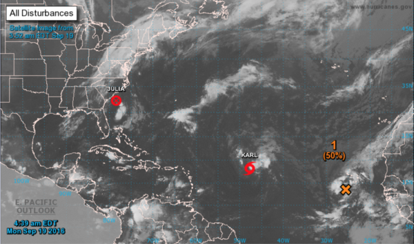
TROPICS: Julia was downgraded to a “remnant low” off the South Carolina coast this morning; what is left of the system will drift into eastern North Carolina tonight and tomorrow.
Tropical Storm Karl could strengthen into a hurricane late this week in the Atlantic; it could be close to the island of Bermuda this weekend, but it will recurve in that region and is no threat to the U.S.
And, a wave in the eastern Atlantic could develop into a tropical storm this week, but it will move northward and is no threat to land.
WEATHER BRAINS: Don’t forget you can listen to our weekly 90 minute netcast anytime on the web, or on iTunes. This is the show all about weather featuring many familiar voices, including our meteorologists here at ABC 33/40. We will produce this week’s show tonight at 8:30 CT… you can watch it live here.
CONNECT: You can find me on all of the major social networks…
Facebook
Twitter
Google Plus
Instagram
I will be doing a weather program this morning at Donehoo Elementary School in Gadsden… look for the next Weather Xtreme video here by 4:00 this afternoon. Enjoy the day!
Category: Alabama's Weather
About the Author (Author Profile)
James Spann is one of the most recognized and trusted television meteorologists in the industry. He holds the AMS CCM designation and television seals from the AMS and NWA. He is a past winner of the Broadcast Meteorologist of the Year from both professional organizations.Subscribe
If you enjoyed this article, subscribe to receive more just like it.


