

Just A Few Showers Around
RADAR CHECK: We actually have a few small, isolated showers on radar this afternoon across North/Central Alabama… they are moving south and will be very short lived. Otherwise, the sky is partly to mostly sunny with temperatures generally in the upper 80s.
REST OF THE WEEK: A quiet weather pattern continues as we officially wrap up the summer of 2016 (the autumnal equinox is Thursday morning at 9:21 a.m.). We project a good supply of sunshine each day through Friday, and no showers are expected tomorrow and Wednesday. And, even on Thursday and Friday any showers that show up will be few and far between.
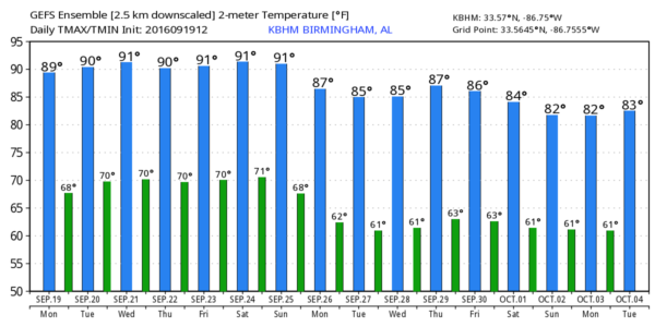
Highs will be in the 88-92 degree range, with lows between 67 and 70. Keep in mind the average high at Birmingham stays in the 80s through the end of September; we usually get the fist good “front of fall” in here around the beginning of October.
THE ALABAMA WEEKEND: Not much change. Partly to mostly sunny Saturday and Sunday with highs not too far from 90 degrees; any afternoon showers will be very isolated.
FOOTBALL WEATHER: For the high school games Friday night, the sky will be mostly fair with temperatures falling through the 80s.
Alabama hosts Kent State at Bryant-Denny Stadium Saturday morning (11:00a CT kickoff)… the sky will be partly to mostly sunny with temperatures rising from near 86 at kickoff, to 90 degrees by the final whistle. The risk of a shower looks very low for now.
Auburn will host LSU at Jordan-Hare Stadium Saturday evening (5:00p CT kickoff)… the sky will be mostly clear with temperatures dropping from near 88 degrees at kickoff to near 80 by the end of the game. The chance of a shower is very small.
NEXT WEEK: The latest GFS model run is not very bullish on showers next week, although a weak front will get closer. There just isn’t much moisture available, and little upper support. See the Weather Xtreme video for maps, graphics, and more details.
AT THE BEACH: About 8 to 10 hours of sunshine daily on the Gulf Coast from Panama City Beach over to Gulf Shores through the weekend with only widely scattered storms. Highs on the immediate coast will be in the upper 80s, with low 90s inland. See a very detailed Gulf Coast forecast here.
TROPICS: Tropical Storm Karl is in the Central Atlantic, and could become a hurricane this weekend as it turns northward. It might be close to Bermuda Saturday, but it will turn eastward back out to sea, and is no threat to the U.S.
A wave in the eastern Atlantic has a good chance of becoming Tropical Storm Lisa in coming days, but it will be gaining latitude and doesn’t look like it will bother any land mass. The rest of the Atlantic basin is quiet.
WEATHER BRAINS: Don’t forget you can listen to our weekly 90 minute netcast anytime on the web, or on iTunes. This is the show all about weather featuring many familiar voices, including our meteorologists here at ABC 33/40. We will produce this week’s show tonight at 8:30 CT… you can watch it live here.
CONNECT: You can find me on all of the major social networks…
Facebook
Twitter
Google Plus
Instagram
I had a great time today visiting with the students at C. A. Donehoo Elementary in Gadsden… be looking for them on the Pepsi KIDCAM today at 5:00 on ABC 33/40 News! The next Weather Xtreme video will be posted here by 7:00 a.m. tomorrow…
Category: Alabama's Weather
About the Author (Author Profile)
James Spann is one of the most recognized and trusted television meteorologists in the industry. He holds the AMS CCM designation and television seals from the AMS and NWA. He is a past winner of the Broadcast Meteorologist of the Year from both professional organizations.Subscribe
If you enjoyed this article, subscribe to receive more just like it.


