

Dry Through Sunday; Changes Next Week
PLEASANT MORNINGS, HOT AFTERNOONS: Once again we are seeing some upper 50s in cooler pockets across Northeast Alabama as this day begins. Vic Bell at Black Creek reports 58 degrees just before daybreak… Fort Payne is at 59.
A dry airmass stays in place for a while, and with upper ridging afternoons will remain fairly hot for September despite the cool mornings. We project highs in the 90-93 degree range through the weekend, almost ten degrees above average for late September in Alabama. But, lower dew points will mean humidity values only in the 20-35 range during the peak of the heat each day. Expect mostly sunny days and fair nights today through Sunday.
FALL ARRIVES TOMORROW: This is the last Wednesday of the summer of 2016; the autumnal equinox is tomorrow morning at 9:21 CT when the sun is directly over the equator.
FOOTBALL WEATHER: For the high school games Friday night, the sky will be mostly fair with temperatures falling through the 80s.
Alabama hosts Kent State at Bryant-Denny Stadium Saturday morning (11:00a CT kickoff)… the sky will be partly to mostly sunny with temperatures rising from near 87 at kickoff, to 92 degrees by the final whistle.
Auburn will host LSU at Jordan-Hare Stadium Saturday evening (5:00p CT kickoff)… the sky will be mostly clear with temperatures dropping from near 89 degrees at kickoff to near 80 by the end of the game.
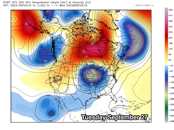
CHANGES NEXT WEEK: The GFS is now showing a decent frontal passage early Tuesday, meaning we can mention a chance of showers and storms Monday night and early Tuesday, followed by cooler/drier air for the middle of next week. Highs drop to near 80, with lows in the 55-60 degree range for most. See the Weather Xtreme video for maps, graphics, and more details.
AT THE BEACH: About 8 to 10 hours of sunshine daily on the Gulf Coast from Gulf Shores to Panama City Beach through the weekend with only isolated thunderstorms. Highs on the immediate coast 86-89, with low 90s inland. See a very detailed Gulf Coast forecast here.
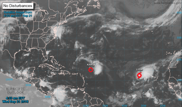
TROPICS: Karl has been downgraded to a tropical depression in the Central Atlantic; it will recurve east of Bermuda this weekend and is no threat to land, although strengthening is possible in a few days.
Tropical Storm Lisa in the eastern Atlantic will move north/northwest, and is no threat to land. The rest of the Atlantic basin is quiet.
WEATHER BRAINS: Don’t forget you can listen to our weekly 90 minute netcast anytime on the web, or on iTunes. This is the show all about weather featuring many familiar voices, including our meteorologists here at ABC 33/40.
CONNECT: You can find me on all of the major social networks…
Facebook
Twitter
Google Plus
Instagram
I am going a safety program this morning for employees at a Regions Bank facility in Riverchase… look for the next Weather Xtreme video here by 4:00 this afternoon. Enjoy the day!
Category: Alabama's Weather
About the Author (Author Profile)
James Spann is one of the most recognized and trusted television meteorologists in the industry. He holds the AMS CCM designation and television seals from the AMS and NWA. He is a past winner of the Broadcast Meteorologist of the Year from both professional organizations.Subscribe
If you enjoyed this article, subscribe to receive more just like it.


