

Big Weather Changes Next Week
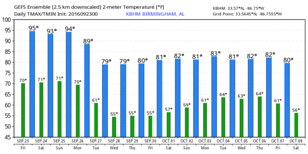
STILL HOT THROUGH THE WEEKEND: Needless to say, this has been a hot September in Alabama. Based on data from the Birmingham Airport through yesterday, we have reached 90 degrees or higher on 19 of 22 days, with the peak of the heat coming on September 15 when the high was 98. The upper ridge will hold through the weekend, meaning highs between 91 and 95 degrees for most places through Sunday. The ridge also means generally dry weather, with any afternoon showers being few and far between… the chance of any one spot getting wet is so small that we won’t mention it in the forecast. Partly to mostly sunny days, fair nights.
FOOTBALL WEATHER: For the high school games tonight, the sky will be mostly fair with temperatures falling through the 80s.
Alabama hosts Kent State at Bryant-Denny Stadium tomorrow morning (11:00a CT kickoff)… the sky will be partly to mostly sunny with temperatures rising from near 88 at kickoff, to 94 degrees by the final whistle.
Auburn will host LSU at Jordan-Hare Stadium tomorrow evening (5:00p CT kickoff)… the sky will be mostly clear with temperatures falling through the 80s.
BIG CHANGES NEXT WEEK: The long awaited pattern change begins. A strong upper ridge, now over the western U.S., will approach, and drive a cold front in our direction. Clouds increase Monday, and showers are possible as the front gets closer. Unfortunately it won’t be a really big, widespread rain like we need, but at least we have a chance of getting a little rain in the bucket. Monday’s high will drop into the mid 80s.
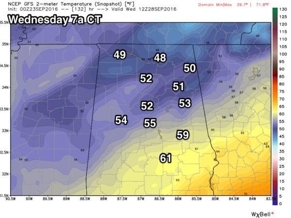
A lingering shower is possible Tuesday, but cooler, drier air will begin to roll into the state, and it looks like we will enjoy some rather refreshing weather Wednesday through Friday with sunny pleasant days, clear cool nights, and low humidity. Highs will be in the 77-80 degree range, with lows down in the 50s. The GFS is suggesting we could see some 40s over the Tennessee Valley of far North Alabama early Wednesday morning.
See the Weather Xtreme video for maps, graphics, and more details.
AT THE BEACH: Mostly sunny days, fair nights, and only isolated storms through the weekend for the coast from Gulf Shores over to Panama City Beach through Sunday. Highs in the upper 80s on the immediate coast, with low 90s inland. See a very detailed Gulf Coast forecast here.
TROPICS: Tropical Storm Karl will recurve in the Atlantic tonight, passing just east of Bermuda, and will head out to sea in the North Atlantic. And, to the east, Tropical Storm Lisa is expected to dissipate over the weekend far from land. A few wave coming off the coast of Africa has some potential for development in 3-5 days; just something to watch for now.
WEATHER BRAINS: Don’t forget you can listen to our weekly 90 minute netcast anytime on the web, or on iTunes. This is the show all about weather featuring many familiar voices, including our meteorologists here at ABC 33/40.
CONNECT: You can find me on all of the major social networks…
Facebook
Twitter
Google Plus
Instagram
I have a program this morning at Carrollton in Pickens County… look for the next Weather Xtreme video here by 4:00 this afternoon. Enjoy the day!
Category: Alabama's Weather
About the Author (Author Profile)
James Spann is one of the most recognized and trusted television meteorologists in the industry. He holds the AMS CCM designation and television seals from the AMS and NWA. He is a past winner of the Broadcast Meteorologist of the Year from both professional organizations.Subscribe
If you enjoyed this article, subscribe to receive more just like it.


