

Hot Weekend; Much Cooler Next Week
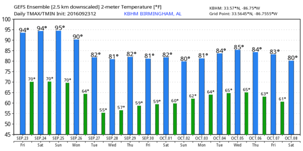
ONE LAST HOT WEEKEND: Summer fans will get one bonus weekend as this pattern won’t be changing. An upper ridge holds, meaning mostly sunny, hot days and fair nights through Sunday. Highs will remain generally in the 92-95 degree range, ten degrees above average for late September. Any afternoon showers will be very hard to find.
FOOTBALL WEATHER: For the high school games tonight, the sky will be mostly fair with temperatures falling through the 80s.
Alabama hosts Kent State at Bryant-Denny Stadium tomorrow morning (11:00a CT kickoff)… the sky will be partly to mostly sunny with temperatures rising from near 88 at kickoff, to 94 degrees by the final whistle. It will be very, very hot in the east stands where the sun will be out in full force (the west side will be more shaded).
Auburn will host LSU at Jordan-Hare Stadium tomorrow evening (5:00p CT kickoff)… the sky will be mostly clear with temperatures falling through the 80s.
NEXT WEEK: The big upper trough over the western states will beat the ridge down, and push a cold front in our direction. We will bring in the chance of showers Monday afternoon through Tuesday morning; unfortunately I don’t think this will be a widespread, or especially beneficial rain event as amounts should be under 1/4″ for many places. Monday’s high will drop into the mid 80s, and on Tuesday the high will be close to 80 degrees; the sky will be occasionally cloudy both days.
We expect beautiful early fall weather Wednesday through Friday as dry air settles in; sunny pleasant days, clear cool nights. The coolest morning should come early Wednesday with low to mid 50s likely… cooler pockets across North Alabama could reach the upper 40s. Highs will be in the 77-82 degree range.
See the Weather Xtreme video for maps, graphics, and more details.
AT THE BEACH: Mostly sunny days, fair nights, only isolated storms on the coast from Panama City Beach to Gulf Shores through Sunday. Highs upper 80s on the immediate coast, with low 90s inland. Scattered showers will be a little more likely early next week… See a very detailed Gulf Coast forecast here.
TROPICS: Tropical Storm Karl will pass just east of Bermuda tonight, then moving northeast out to sea. TropicaL Storm Lisa is expected to dissipate this weekend in the eastern Atlantic far from land. A new wave just off the coast of Africa will have some potential for development in 3 to 5 days. Just something to watch for now.
WEATHER BRAINS: Don’t forget you can listen to our weekly 90 minute netcast anytime on the web, or on iTunes. This is the show all about weather featuring many familiar voices, including our meteorologists here at ABC 33/40.
CONNECT: You can find me on all of the major social networks…
Facebook
Twitter
Google Plus
Instagram
I had a great time today seeing the kids at the Pickens County Early Learning Center in Carrollton… be looking for them on the Pepsi KIDCAM today at 5:00 on ABC 33/40 News! My next Weather Xtreme video will be posted here Monday morning by 7:00… Brian Peters will have the video updates tomorrow and Sunday. Enjoy the weekend!
Category: Alabama's Weather
About the Author (Author Profile)
James Spann is one of the most recognized and trusted television meteorologists in the industry. He holds the AMS CCM designation and television seals from the AMS and NWA. He is a past winner of the Broadcast Meteorologist of the Year from both professional organizations.Subscribe
If you enjoyed this article, subscribe to receive more just like it.


