

Pleasant Days; Cool Nights
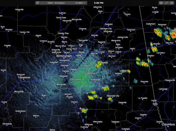
RADAR CHECK: As expected, we have a few isolated showers and storms south and east of Birmingham this afternoon… they won’t last long, and most places will be dry this evening…
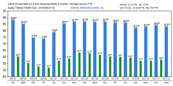
Temperatures are mostly in the mid 80s, and the sky is partly sunny. Tonight will be fair and very pleasant with temperatures in the 50s early tomorrow. Then, during the day tomorrow the sky will be mostly sunny, and once again we rise into the mid 80s.
THURSDAY/FRIDAY: A secondary surge of cool air drops into the state. We project highs only in the mid 70s both days, with lows well down in the 50s. Sunny days, clear nights.
THE ALABAMA WEEKEND: The latest GFS is printing a low of 52 degrees for Birmingham early Saturday morning; colder spots go down in the 40s. Then, the sky will stay sunny Saturday and Sunday with highs in the upper 70s Saturday, and close to 80 Sunday.
FOOTBALL WEATHER: Looking fantastic for Friday night’s high school games; a clear sky with temperatures falling through the 60s during the games (remember, they were falling through the 80s this past Friday night). Some stadiums will see 50s by the fourth quarter, and a light jacket will be in order.
Alabama will host Kentucky Saturday evening at Bryant-Denny Stadium (6:00p CT kickoff)… the sky will be clear with temperatures falling from 73 at kickoff, into the mid 60s by the fourth quarter.
Auburn hosts Louisiana-Monroe Saturday at Jordan Hare Stadium (2:30p CT kickoff)… expect a sunny sky with a kickoff temperature of 76 degrees…falling into the upper 60s by the final whistle.
NEXT WEEK: We stay dry with mostly sunny days and fair nights; highs in the 80s; lows around 60. See the Weather Xtreme video for maps, graphics, and more details.
AT THE BEACH: Just a few widely scattered storms around tonight and tomorrow, otherwise mostly sunny days and fair nights through the weekend from Gulf Shores to Panama City Beach. Highs in the 80s. Interesting to note there was a waterspout at Orange Beach late this morning… photo below from William Wesson…

TROPICS: Invest 97L will move into the Caribbean tomorrow, and is expected to become Tropical Storm Matthew by the end of the week. Most tropical models turn the system northward, with a movement between Cuba and Haiti up toward the Bahamas. But, remember this system doesn’t even have a low level circulation now, and I would not trust any guidance until we get an organized cyclone for good initialization.
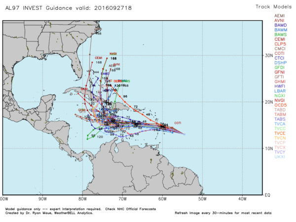
There is a chance this becomes a significant hurricane, so it bears watching in coming days.
WEATHER BRAINS: Don’t forget you can listen to our weekly 90 minute netcast anytime on the web, or on iTunes. This is the show all about weather featuring many familiar voices, including our meteorologists here at ABC 33/40.
CONNECT: You can find me on all of the major social networks…
Facebook
Twitter
Google Plus
Instagram
I had a great time today visiting with the kindergarten students at Coldwater Elementary in Calhoun County… be looking for them on the Pepsi KIDCAM today at 5:00 on ABC 33/40 News! The next Weather Xtreme video will be posted here by 7:00 a.m. tomorrow…
Category: Alabama's Weather
About the Author (Author Profile)
James Spann is one of the most recognized and trusted television meteorologists in the industry. He holds the AMS CCM designation and television seals from the AMS and NWA. He is a past winner of the Broadcast Meteorologist of the Year from both professional organizations.Subscribe
If you enjoyed this article, subscribe to receive more just like it.


