

Drought Conditions Worsening Across Alabama
LONG DRY SPELL AHEAD: A number of wildfires have been reported across Alabama today; authorities are evacuating homes and businesses in West Jefferson County as firefighters battle a fast-spreading fire… The fire is affecting the McCalla area near Serene Drive and War Eagle Drive. A command post has been set up and deputies are going door to door making sure residents leave their homes. I saw two wildfires along I-65 between Cullman and Birmingham today.
Coleen Vansant with the Alabama Forestry Commission sent us this note:
“I wanted to fill all of you in on the current wildfire situation. Over the past few days we have experienced an increase in wildfire activity across central, northeast, and east central Alabama. We are in our usual fall fire season but the extended drought across much of the state, particularly from I-65 east is creating greater problems for wildland firefighters. In the past few days, dry conditions combined with low humidity and an increase in wind is creating a favorable weather environment for wildfire. Yesterday, Wednesday, September 28, 2016 the state had 38 wildfires for 282 acres. In the last seven days we have had 137 wildfires for approximately 1,540 acres. Most of these fires have occurred east of Interstate 65 and north of Randolph County to the Tennessee line.
Although we are under no burning restrictions at this time, the Alabama Forestry Commission is urging everyone to use extreme safety precautions when doing any type of outdoor burning. The best thing to do is postpone any burning until measurable rainfall is received.”
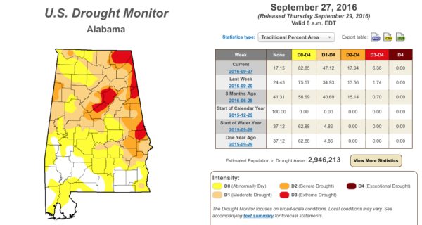
Unfortunately there is little if any hope for rain over the next ten days across Alabama, so drought conditions will only worsen. Please be very careful if you are doing any outdoor burning.
COOLEST AIR SO FAR: As advertised, temperatures are only in the mid 70s across Alabama this afternoon with a fresh north breeze; tonight will be clear and cool with temperatures dropping well down in the 50s early tomorrow; colder pockets will visit the 40s. Tomorrow will be just like today; ample sunshine and a high between 74 and 77.
THE WEEKEND: Still dry; sunny Saturday and Sunday with a slow warming trend. The high Saturday will be in the 77-80 degree range, followed by low 80s Sunday. Lows will stay in the 50s.
FOOTBALL WEATHER: Looking fantastic for Friday night’s high school games; a clear sky with temperatures falling through the 60s during the games (remember, they were falling through the 80s this past Friday night). Some stadiums will see 50s by the fourth quarter, and a light jacket will be in order.
Alabama will host Kentucky Saturday evening at Bryant-Denny Stadium (6:00p CT kickoff)… the sky will be clear with temperatures falling from 73 at kickoff, into the mid 60s by the fourth quarter.
Auburn hosts Louisiana-Monroe Saturday at Jordan Hare Stadium (2:30p CT kickoff)… expect a sunny sky with a kickoff temperature of 76 degrees…falling into the upper 60s by the final whistle.
NEXT WEEK: Sunny days, fair nights, highs in the 80s and lows around 60. See the Weather Xtreme video for maps, graphics, and more details.
BARBER VINTAGE MOTORCYCLE FESTIVAL: This event runs from Friday October 7 through Sunday October 9 at the Barber Motorsports Park. No real skill in a specific forecast this far out, but October is our driest month of the year, and for now we see nothing to suggest any significant chance of rain event on these three days. Get ticket information right here.
AT THE BEACH: Mostly sunny days, fair nights, and only isolated storms through most of next week for the coast from Gulf Shores over to Panama City Beach; highs hold in the 80s. See a very detailed Gulf Coast forecast here.
MATTHEW IS NOW A HURRICANE: Still looks like Matthew will make a hard right turn over the Caribbean this weekend; it should be over eastern Cuba by Monday or Monday night.
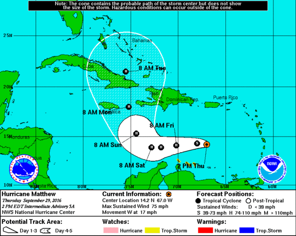
Almost all reliable model guidance keeps Matthew well east of the Gulf of Mexico… but it could very well be a threat to parts of the U.S. East Coast next week. See the Weather Xtreme video for more maps and details.
WEATHER BRAINS: Don’t forget you can listen to our weekly 90 minute netcast anytime on the web, or on iTunes. This is the show all about weather featuring many familiar voices, including our meteorologists here at ABC 33/40.
CONNECT: You can find me on all of the major social networks…
Facebook
Twitter
Google Plus
Instagram
I had a great time today visiting with the 6th graders at East Elementary in Cullman… and the 3rd graders at Hayden Elementary in Blount County… be looking for them on the Pepsi KIDCAM today at 5:00 and 6:00 on ABC 33/40 News! The next Weather Xtreme video will be posted here by 7:00 a.m. tomorrow…
Category: Alabama's Weather
About the Author (Author Profile)
James Spann is one of the most recognized and trusted television meteorologists in the industry. He holds the AMS CCM designation and television seals from the AMS and NWA. He is a past winner of the Broadcast Meteorologist of the Year from both professional organizations.Subscribe
If you enjoyed this article, subscribe to receive more just like it.


