

Matthew a Little Stronger; Huge Impact for Haiti, Jamaica, Cuba; Close Call for U.S. this Week.
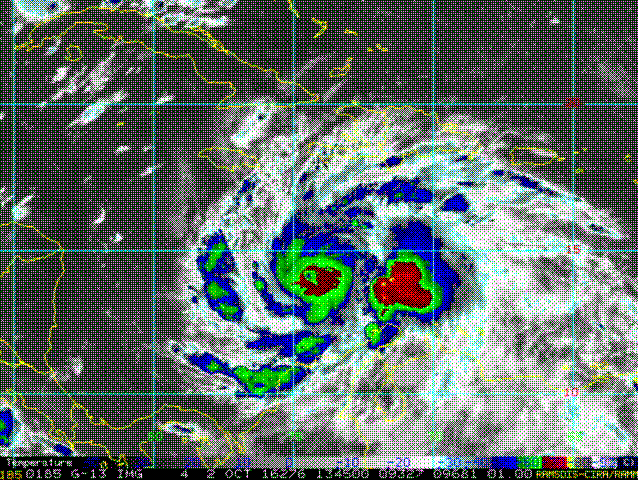
Hurricane Matthew appears to be strengthening again this afternoon while describing a small cyclonic loop. The overall motion continues to be northwesterly at about 5 mph. Maximum winds are 145 mph. The center of Matthew is about 275 miles south of the western tip of the Tiburon Peninsula in southern Haiti.
Matthew will bring huge effects to Haiti, Jamaica and eastern Cuba. It has taken the slightly further east track predicted by the European model and the center will likely make landfall on the very vulnerable Tiburon Peninsula of Haiti then weave over the eastern tip of Cuba. Hurricane warnings cover the entire coastline of Haiti, Jamaica and eastern Cuba. Let’s look at the threats to these locations.
WIND: Tropical storm force winds will reach Jamaica and Haiti overnight tonight, making preparations nearly impossible, so residents are being urged to finish those preps today. Hurricane conditions will spread across the western tip of Haiti Monday night and then across eastern Cuba Tuesday morning. The area of hurricane force winds is very small right now, despite the overall intensity, reaching out only about 20-30 miles.
RAINFALL: 15-25 inches of rain will spread across southern Haiti, with up to 40 inches possible. This will create deadly flooding and mudslides.
SURGE: Devastating surge will inundate coastal areas of Haiti and Cuba, with surge heights running 6-11 feet. 3-5 feet will affect Jamaica.
BAHAMAS UP NEXT: Matthew will slice through the Bahamas starting Tuesday night through Wednesday as a major hurricane. The mountainous terrain of Hispaniola and eastern Cuba will knock a little but of the stuffing out the storm, but it still should be a major hurricane when it gets to the Bahamas. Wind shear will begin to increase, but the storm will be over warm water, so it should maintain strength.
STRENGTH GOING FORWARD: Matthew will move into slightly cooler water north of the Bahamas and wind shear will begin to increase, so the idea is that Matthew should start to slowly weaken by Tuesday. Still, it will likely be at least a category two hurricane through the end of the week.
THREAT TO THE U.S.: Matthew will spend Thursday menacing northeastern Florida, Georgia and the Carolinas. The East Coast will be holding its breath, hanging on every model run, and hoping the storm turns out to sea. There is a tremendous amount of uncertainty about he eventual track, which is often the case with a hurricane that is running the East Coast. Just a minor variation in course can make a big difference in impact.
DECIDING FACTOR: The big ridge of high pressure centered over the Atlantic could push the storm into the U.S. East Coast. But the upper low over the Great Lakes wants to erode the western end of that ridge and open a channel for the hurricane to escape to the northeast this week. The battle will be to see whether the ridge can build back in or not. Indications are that the escape route will remain open, which would allow Matthew to escape the trap and keep the U.S. East Coast safe. It will be an interesting, nervous week.
MORNING RUNS: The European has come back to showing a more westerly track that leads to a close call along the Outer Banks of North Carolina and still hints that the hurricane could affect New England in about 10 days. The GFS is in pretty good agreement with that theory up through the Outer Banks, but carries it well east of New England. Stay tuned.
Category: Alabama's Weather
About the Author (Author Profile)
Bill Murray is the President of The Weather Factory. He is the site's official weather historian and a weekend forecaster. He also anchors the site's severe weather coverage. Bill Murray is the proud holder of National Weather Association Digital Seal #0001 @wxhistorianSubscribe
If you enjoyed this article, subscribe to receive more just like it.


