

Midday Update: Matthew Tracking North Along Florida East Coast
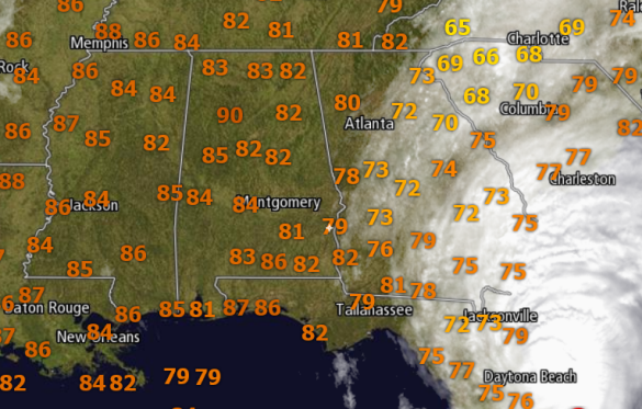
Calm weather for us in Alabama, and overall it is a mainly clear and very warm day for us all across North/Central Alabama. Very few clouds and certainly no rain. Temperatures have been able to make well into the 80s for many of us as dry air continues to be pulled south and is entrenching itself over Alabama. No rain today and we are not going to see any rain from Matthew. We certainly need the rain as drought conditions only get worse. We do note that we are seeing breezy conditions at times due to the proximity of Matthew southeast of us. Winds are ranging out of the north from 5-15mph.
For those high school football games tonight, it is going to be a rather mild night. Temperatures at kickoff should be around the upper 70s, then falling into the lower 70s by the final whistle. Winds will continue to blow around 5-10 mph out of the north.
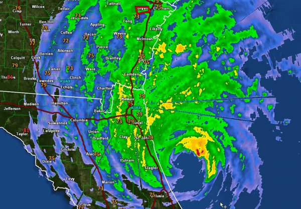
Now lets talk about the main story in the weather world…Hurricane Matthew. Matthew continues a northward progression along the east coast of Florida. We can see below the the eye is still off shore, but the western eyewall has been impacting the coast today, and we have seen wind gusts over 100mph near Cape Canaveral earlier this morning and recently a 90mph gust at Daytona Beach. Hurricane-force winds extend outward up to 60 miles from the center and tropical-storm-force winds extend outward up to 185 miles. A wind gust to 84 mph was also recently reported at Ponte Vedra, and a coastal marine observing station at St. Augustine recently measured a wind gust of 85 mph.
At 200 PM EDT, the eye of Hurricane Matthew was located near latitude 29.7 North, longitude 80.7 West. Matthew is moving toward the north-northwest near 13 mph, and this general motion is expected to continue today. A turn toward the north is expected tonight or Saturday. On the forecast track, the center of Matthew will continue to move near or over the coast of northeast Florida and Georgia through tonight, and near or over the coast of South Carolina on Saturday.
Maximum sustained winds are near 115 mph with higher gusts. Matthew is a category 3 hurricane on the Saffir-Simpson Hurricane Wind Scale. Although weakening is forecast during the next 48 hours, Matthew is expected to remain a hurricane until it begins to move away from the United States on Sunday.
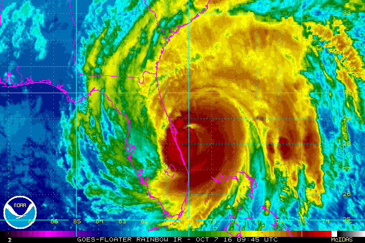
A tidal gauge at Fernandina Beach reported a storm surge inundation of 3.11 feet above mean higher high water. The latest minimum central pressure reported by an Air Force Hurricane Hunter plane was 947 mb (27.97 inches).
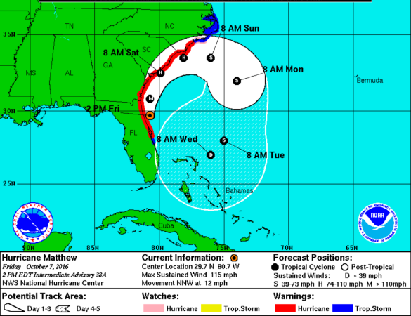
The track will continue along the Southeast Coast as we head through the weekend, and up next on impacts from Matthew are Georgia and the Carolinas, where hurricane warnings are in effect as hurricane conditions are expected in these areas the next 24-48 hours.
Category: Alabama's Weather
About the Author (Author Profile)
Macon, Georgia Television Chief Meteorologist, Birmingham native, and long time Contributor on AlabamaWX. Stormchaser. I did not choose Weather, it chose Me. College Football Fanatic. @Ryan_StinnetSubscribe
If you enjoyed this article, subscribe to receive more just like it.


