

Cooler but Continued Bone Dry!
***NOTE: While preparing the video, NHC has dropped Matthew to a Category 1 hurricane with wind estimated to be 85 mph. ***
Alabamians waking up to a clear sky this morning across the state while Hurricane Matthew continued to pummel South Carolina and part of the Georgia coastal region. A cold front was moving through Central Alabama early this morning, but we won’t see any precipitation with this front as the air on both sides of it is very dry. The big element we’ll see thank to the front will be a nice drop in temperatures especially across the northwest quadrant of the state. For the Birmingham area, we hit 91 degrees for the high yesterday, but the high today should only reach the range of 83 to 86. This also means the drought conditions will continue for the foreseeable future.
Auburn and Alabama are on the road this weekend. Auburn will play at Mississippi State at 11:00 am CDT today with the sky sunny and temperatures rising from 74 at kickoff to near 82 degrees by the fourth quarter.
Alabama will play Arkansas at Fayetteville this evening with a 6:00 pm CDT kickoff. Weather should be nearly perfect for football with temperatures falling from 67 at kickoff into the 50s by the fourth quarter. The sky will be clear.
If you have plans for beach going, you will find sunny days and clear nights on the coast from Dauphin Island to Panama City Beach through next week. Highs will be mostly in the 80s and lows around 60. See a very detailed Gulf Coast forecast here.
The Barber Vintage Motorcycle Festival runs through Sunday at the Barber Motorsports Park. Highs will in the lower 80s today and Sunday with sunny days and clear nights. Get ticket information right here.
SPC has only a couple of marginal risk areas on Day 1 along the South Carolina/North Carolina coast and in Southeast Arizona.
NHC is keeping an eye on Matthew and Nicole. Nicole has become a mere shadow of itself overnight as strong westerly shear has exposed the low level circulation. Nicole likely to remain a tropical storm for the next few days with little likelihood that it will strengthen due to the shear.
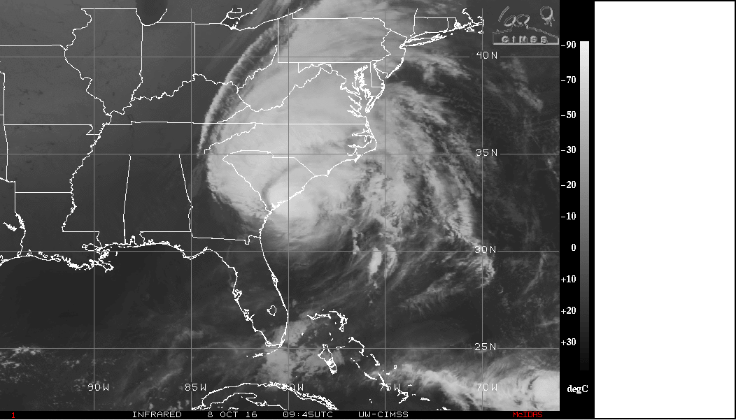
Matthew was just offshore of Charleston as I was writing this. The eye continued to move right along the coastline, closer than it did to the Florida East Coast Thursday night and Friday, but still no sign that it will actually cross the coast to become a landfalling hurricane. Matthew was down to a Category 2 hurricane this morning with maximum wind speeds estimated to be around 105 mph. With the closeness of the eye to the coast, it is possible that it will make landfall later this morning or this afternoon.
Surface high pressure form the Great Lakes region will provide a northeasterly flow for Alabama through the weekend and into Monday. The upper flow sees a weak trough move into New England by Sunday while the ridge to our west becomes the primary feature in the upper flow for us through the week ahead.
The upper ridge will be flattened a good deal with the passage of a strong trough through the Great Lakes area by Thursday. This will once again bring a cold front into the Southeast US, but there is little hope we’ll see any rain, just a few passing clouds. The upper ridge builds back for the end of the week and the weekend while a surface high moves across the Northeast US. The position of the surface high could set up a wedge pattern (cold air damming) for the Southeast US into the start of next weekend.
Looking further afield, the GFS was showing a substantial upper ridge for the eastern half of the country around the 18th of October while the western US would see a strong trough. The strong trough kicks out across the Mississippi River around the 21st of October, and this appears to be our best chance at seeing some rain over the next two weeks. We should cool off and dry out again around the 23rd of October as the upper trough moves to the East Coast of the US.
I anticipate having the next Weather Xtreme Video posted here by 7:30 or so on Sunday morning. Enjoy the great weather today and Godspeed.
-Brian-
Category: Alabama's Weather
About the Author (Author Profile)
Brian Peters is one of the television meteorologists at ABC3340 in Birmingham and a retired NWS Warning Coordination Meteorologist. He handles the weekend Weather Xtreme Videos and forecast discussion and is the Webmaster for the popular WeatherBrains podcast.Subscribe
If you enjoyed this article, subscribe to receive more just like it.


