

Chilly, but Uneventful Weather
It is the coldest air we’ve seen so far this Fall season. Black Creek had reached 34 degrees, Noccalula Falls was down to 43, Concord 39, and I had 43 in Helena. Definitely a morning for a light jacket as you head out for the day, but with clear skies we should see highs climb nicely to the upper 60s and lower 70s across Central Alabama.
Beach forecast looks good. You will see sunny days and fair nights on the coast through next week. Highs will be in the 70s today and near 80 Sunday while morning lows will be in the 50s. These temperatures will last through much of next week. See a very detailed Gulf Coast forecast here.
Football weather looks fantastic! Clear skies and nearly perfect temperatures are expected in Tuscaloosa as Alabama hosts Texas A&M at 2:30 pm CDT today. Temperatures will be at or just over 70 degrees at kickoff and will fall to near 60 by 6:00 pm. For those headed to The Plains, clear skies and cool temperatures are forecast in Auburn as they play host to Arkansas at 5:00 pm CDT this evening. Temperatures will be in the mid 60s at kickoff and falling into the middle 50s by 9:00 pm.
For the race weekend at Talladega, you can expect to see a bright, sunny sky today and Sunday with great temperatures. Highs today will be in the upper 60s, followed by a high in the mid to upper 70s on Sunday. Temperatures will be crisp and cool both this morning and Sunday morning, with the mercury dropping to near 40 degrees at the Superspeedway. Definitely some hot chocolate and coffee needed for the early morning along with a jacket to start the day.
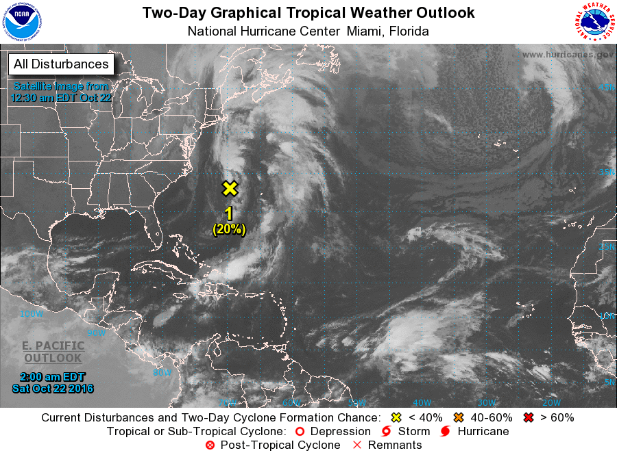
Watch the video for details on the SPC outlooks. Hint, you don’t see this kind of graphic very often. And the tropics remain quiet with a disturbance located about 400 miles east-southeast of the Outer Banks. The current motion to the northeast will continue with the rain likely to move over the Maritime Provinces of Canada later in the week.
The overall weather pattern for the next week looks pretty uneventful. The upper ridge will move over us by Tuesday and Wednesday while we stay under high pressure at the surface. Unfortunately, the next system comes across well to our north Wednesday and Thursday, but there is not going to be any serious moisture return, so while we’ll see another frontal boundary move through the Southeast US late Wednesday and Thursday, it is going to be moisture starved much like we saw with the last promising event. The forecast will have to reflect a small chance at a shower, but again most of us remain dry. That system is followed quickly by another upper ridge, so we simply cannot buy any rain.
Looking out into voodoo country, the overall upper air pattern remains somewhat flat into the start of November with the stronger traveling weather systems well to our north. Another strong trough enters the picture around November 5th, but we continue to struggle with moisture issues. Without moisture, we just simply cannot wring any showers or thunderstorms out of the atmosphere.
I had a wonderful time yesterday at Fuller’s SuperMarket in Greensboro chatting with folks and programming weather radios. Special thanks to Mr. Fuller for inviting the ABC 3340 Weather Team into the community. Many more folks are now prepared for our secondary severe weather season with the baseline of a weather radio. I expect to have the next video posted here on Sunday morning. Enjoy this marvelous day and Godspeed.
-Brian-
Category: Alabama's Weather
About the Author (Author Profile)
Brian Peters is one of the television meteorologists at ABC3340 in Birmingham and a retired NWS Warning Coordination Meteorologist. He handles the weekend Weather Xtreme Videos and forecast discussion and is the Webmaster for the popular WeatherBrains podcast.Subscribe
If you enjoyed this article, subscribe to receive more just like it.


