

Severe Clear At Midday for Central Alabama
A GLORIOUS MIDDAY NOWCAST, UNLESS IF YOU’RE EXPECTING RAIN:
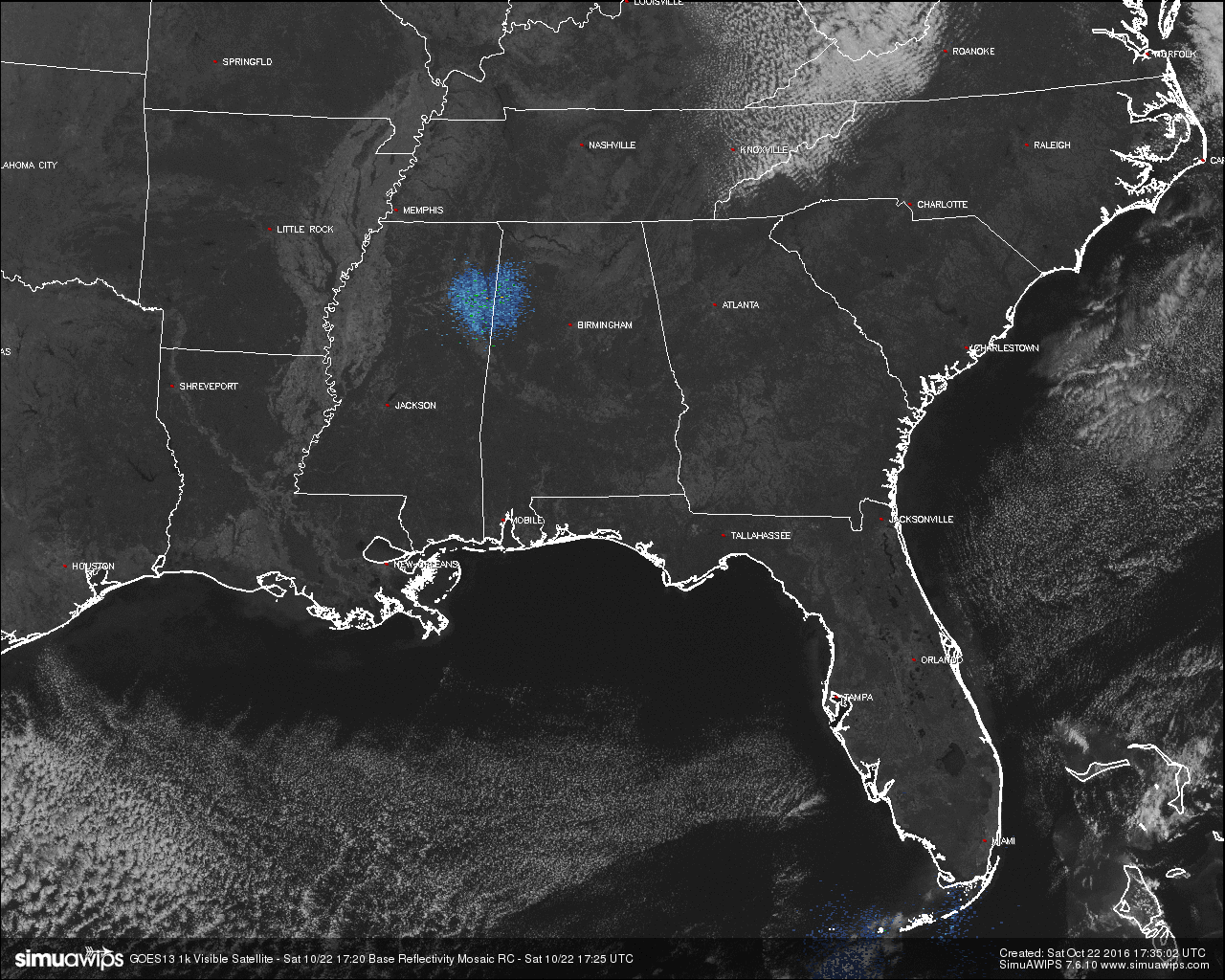
After starting off in the upper 30s to low 40s throughout Central Alabama this fine Saturday morning, the afternoon will be really nice. Skies are absolutely clear across the area and temperatures are in the 60s. looking at the latest visible satellite image with radar, not a single bit of precipitation is showing up at all, and the only clouds are up over the Appalachian Mountains in Eastern Tennessee, extreme Western North Carolina, and up to the north extending out of the image.

BURN BAN AND FIRE ALERT:
A Drought Emergency continues in effect, banning any outdoor burning for the northern two-thirds of the state. A Fire Alert remains in effect for the whole state. Only those counties outside of the Drought Emergency can burn outdoors after obtaining a burn permit from the Alabama Forestry Commission, but these will be restricted and issued on an individual basis. Click here for more information.
TEMPERATURES ACROSS CENTRAL ALABAMA AT 12:15 PM CDT:
- Birmingham 64
- Tuscaloosa 66
- Gadsden 64
- Anniston 63
- Cullman 61
- Alexander City 67
- Auburn 64
- Selma 66
- Montgomery 66
AIR QUALITY:
Both Ozone and Particulate Matter 2.5 levels will be below criteria to raise an Air Quality Alert for the Birmingham metropolitan area today. No actions needed.
NORMS AND RECS FOR TODAY IN BIRMINGHAM:
The normal high for October 22nd is 73, while the normal low is 48. The record high for today was set back in 1941 at 89. The record low was set back in 1987 at 28.
REST OF TODAY:
The sun will be out in the max, but afternoon highs will only make it into the upper 60s to low 70s. Winds will mainly be out of the north at 10 to 15 MPH. Skies will be clear throughout tomorrow evening, with temperatures falling into the upper 40s to low 50s by 10:00PM. Winds will become calm during the overnight hours, and lows will drop into the upper 30s to low 40s.
ALABAMA FOOTBALL:
Clear skies and nearly perfect temperatures in Tuscaloosa as Alabama will host Texas A&M at 2:30PM CDT today. Temperatures will be just over 70 degrees at kickoff, and falling into the mid 60s by 6:00PM.
AUBURN FOOTBALL:
Clear skies and cool temperatures in Auburn as they play host to Arkansas at 5:00PM CDT this evening. Temperatures will be in the mid 60s degrees at kickoff, and falling into the mid 50s by 9:00PM.
RACE WEEKEND AT TALLADEGA:
Expect a bright sunny sky today and Sunday with fantastic temperatures. Highs tomorrow will be in the upper 60s, followed by a high in the mid to upper 70s on Sunday. Temperatures will be crisp and cool both this morning and Sunday morning, with the mercury dropping to near 40 degrees at the Superspeedway. Definitely some hot chocolate and coffee needed for the early morning.
TOMORROW’S FORECAST:
We’ll start a little warming trend as the sun will be out in full force, and with the lack of moisture in the soil, it won’t take much for the temperatures to approach the upper 70s to low 80s for daytime highs across Central Alabama. As the evening approaches, skies will be clear and temperatures will drop into the mid to upper 50 by 10:00PM, with overnight lows dropping into the mid and upper 40s.
NEXT WEEK:
Sunny days, fair nights. We might consider a small risk of a shower Thursday with a wave passing north of the state, but drought conditions will worsen. Highs at or near 80 degrees each day, with lows in the 50s.
HEADED TO THE BEACH:
Sunny days, fair nights on the coast through next week. Highs in the 70s today, and in the low 80s Sunday and through much of next week. See a very detailed Gulf Coast forecast here.
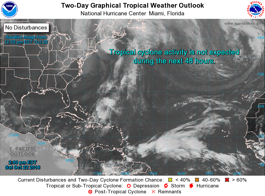
TROPICAL UPDATE:
Tropical cyclone formation is not expected during the next 5 days across the Gulf of Mexico, Caribbean Sea, and the North Atlantic Ocean.
ON THIS DAY IN 1989:
A storm system moving out of the Gulf of Alaska brought rain to the Northern and Central Pacific Coast Region, with snow in some of the mountains of Oregon, and wind gusts to 60 mph along the Oregon coast. Six cities in Florida reported record low temperatures for the date, including Tallahassee with a reading of 34 degrees.
THE BLOG IS ON TWITTER:
Be sure to follow the Alabama Wx Weather Blog on Twitter. Just click here to start following our feed.
WEATHERBRAINS:
This is the weekly netcast that’s all about weather featuring many familiar voices, including our meteorologists at ABC 33/40. You can listen anytime on the web, or on iTunes. You can find it here.
ADVERTISE WITH US:
Deliver your message to a highly engaged audience by advertising on the AlabamaWX.com website. The site enjoyed 10.2 MILLION pageviews in the past 12 months. Don’t miss out! We can customize a creative, flexible and affordable package that will suit your organization’s needs. Contact Bill Murray at (205) 687-0782.
Category: Alabama's Weather
About the Author (Author Profile)
Scott Martin is an operational meteorologist, professional graphic artist, musician, husband, and father. Not only is Scott a member of the National Weather Association, but he is also the Central Alabama Chapter of the NWA president. Scott is also the co-founder of Racecast Weather, which provides forecasts for many racing series across the USA. He also supplies forecasts for the BassMaster Elite Series events including the BassMaster Classic.Subscribe
If you enjoyed this article, subscribe to receive more just like it.


