

Cold Front Arrives Early Saturday; Rain???
DRY IS THE WORD: Today is the 57th consecutive day without measurable rain for Birmingham, and a drought emergency remains in effect for all 67 Alabama counties. No outdoor burning of any kind, and water conservation is very important.
The sky is mostly sunny with temperatures in the 68-71 degree range at most places this afternoon. The average high for November 14 (for Birmingham) is 65.
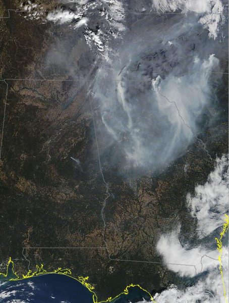
Smoke today from wildfires across TN/GA/SC/NC is mostly over Georgia, but some is over far northeast Alabama…
MID-WEEK: A weak wave aloft will bring some clouds tomorrow, and maybe even a few isolated showers, but the chance of any one spot getting wet is very small since the air is so dry. Wednesday and Thursday will be mostly sunny. Expect a high in the low 70s tomorrow and Wednesday… followed by upper 70s Thursday. In fact, a few spots could touch 80 degrees Thursday afternoon since we have no soil moisture.
FYI… the latest 80 degree high in Birmingham on record came on December 7, 1951 when the high was exactly 80 degrees.
COLD FRONT! Friday will be another dry, mild day, but a cold front will blow into Northwest Alabama late Friday night with a band of showers, and maybe even a thunderstorm. But, don’t get too excited since moisture will be pretty limited, and the main dynamic forcing will be well to the north. But, this could end Birmingham’s long dry spell.
The European global model is printing 0.20″ of rain for Birmingham, with potential for around 1/2″ for the northwest counties of the state…
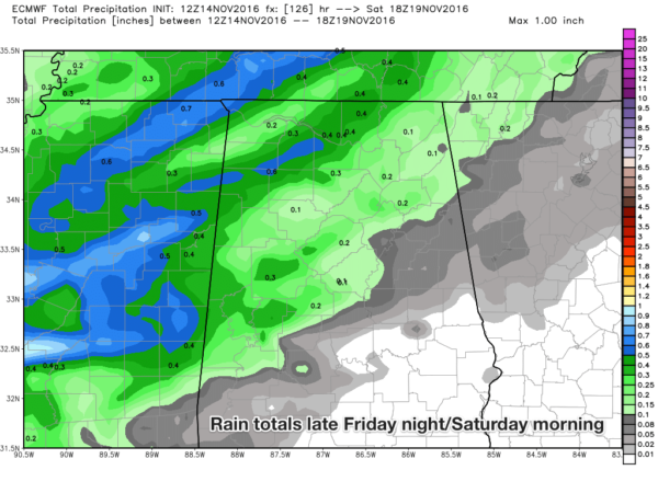
The main window for showers will come from about 9:00 p.m. Friday through 9:00 a.m. Saturday. Unfortunately South Alabama probably won’t get a drop of rain.
THE WEEKEND: The coldest air so far this season blows in here after the showers over the weekend. It now looks like temperatures will hover in the cool 50s Saturday, and some North Alabama communities won’t get out of the 40s Sunday with a chilly north wind of 10-20 mph. The GFS is printing a low of 33 early Sunday, and 23 Monday (that isn’t a typo) for Birmingham. Sure looks like our growing season will end with freezing temperatures likely for the northern half of the state.
The sky becomes partly sunny Saturday afternoon, and Sunday will feature a good supply of sunshine.
FOOTBALL WEATHER: For the high school football playoff games Friday night, rain is possible over the northwest corner of the state, otherwise clouds will increase with temperatures in the 60s.
Alabama will host Chattanooga Saturday night at Bryant-Denny Stadium (6:00p CT kickoff)… the sky will be mostly fair with temperatures falling from 58 at kickoff into the chilly 40s for the second half.
Auburn hosts Alabama A&M Saturday night at Jordan-Hare Stadium (6:30p CT kickoff)… mostly fair with temperatures falling from the mid 50s at kickoff, and into the 40s by the fourth quarter.
THANKSGIVING WEEK: For now it looks generally dry with cool days and cold nights… see the Weather Xtreme video for maps, graphics, and more details.
SUPERMOON: The moon this morning was the closest full moon to Earth since 1948. We won’t see another supermoon like this until 2034. The moon’s orbit around Earth is slightly elliptical so sometimes it is closer and sometimes it’s farther away. When the moon is full as it makes its closest pass to Earth it is known as a supermoon. At perigee — the point at which the moon is closest to Earth — the moon can be as much as 14 percent closer to Earth than at apogee, when the moon is farthest from our planet. The full moon appears that much larger in diameter and because it is larger shines 30 percent more moonlight onto the Earth.
So… be looking again tonight. Moonrise for Birmingham today is 5:19p CT.
AT THE BEACH: Sunny days, fair nights from Panama City Beach to Gulf Shores through the weekend with highs in the 70s through Saturday, dropping into the 60s Sunday and early next week. See a very detailed Gulf Coast forecast here.
TROPICS: A tropical disturbance over the western Caribbean has come potential to develop later this week, but no impact on the Southeast U.S.
WEATHER BRAINS: Don’t forget you can listen to our weekly 90 minute netcast anytime on the web, or on iTunes. This is the show all about weather featuring many familiar voices, including our meteorologists here at ABC 33/40. We will produce this week’s show tonight at 8:30P CT… you can watch it live here.
CONNECT: You can find me on all of the major social networks…
Facebook
Twitter
Google Plus
Instagram
I had a great time today visiting with the kindergarten students at Vestavia Hills East Elementary… be looking for them on the Pepsi KIDCAM today at 5:00 on ABC 33/40 News! The next Weather Xtreme video will be posted here by 7:00 a.m. tomorrow…
Category: Alabama's Weather
About the Author (Author Profile)
James Spann is one of the most recognized and trusted television meteorologists in the industry. He holds the AMS CCM designation and television seals from the AMS and NWA. He is a past winner of the Broadcast Meteorologist of the Year from both professional organizations.Subscribe
If you enjoyed this article, subscribe to receive more just like it.


