

Showers Move In Late Tomorrow Night
WARM NOVEMBER DAY: Birmingham, Anniston, and Tuscaloosa were all at 79 degrees at 3:00 this afternoon, very close to record levels for November 17. Birmingham’s record high today is 82, set in 1958.
Today is the 60th consecutive day without measurable rain for Birmingham (based on data from the airport, where records are kept). The last measurable rain was on September 18 with 0.32″. The last time we had over one inch in a 24 hour period came on July 30, when the total was 1.33″.
Since the first of October, a total of 1,721 wildfires have destroyed over 20,000 acres of land in Alabama, and a drought emergency continues. No outdoor burning, and we all need to conserve water.
TO THE NORTHWEST: A major snowstorm/blizzard will crank up across the Northern Plains tonight and tomorrow; blizzard warnings are in effect for parts of ND/SD/MN, and snow is falling in Denver this afternoon.
The trailing cold front moves into Alabama late tomorrow night; before it arrives the day tomorrow will be warm and dry with a good supply of sunshine and a high around 80, much like today.
Showers enter the northwest corner of Alabama between 10:00 and 12:00 midnight tomorrow night; some thunder is possible around Muscle Shoals. Then, a slowly weakening band of showers will move across North and Central Alabama between midnight tomorrow night and 6:00 a.m. Saturday.
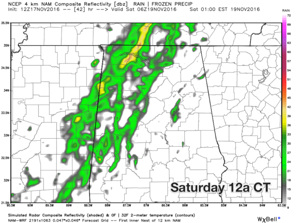
For most places, rain amounts will be under 0.10″, so this won’t make a dent in the drought, but it should stop Birmingham’s string of consecutive dry days at 61.
MUCH COLDER OVER THE WEEKEND: The sky will be mostly sunny Saturday, but a strong northwest wind of 12-25 mph will usher in the coolest air so far this season. We won’t get past the mid 50s Saturday afternoon, and that wind will make it feel colder.
Sunday morning will be a cold with a low very close to the freezing mark; the NAM is printing a low of 31 for Birmingham. Then, expect sunshine in full force Sunday with a high in the mid 50s, but not as windy as Saturday.
Coldest morning most likely will come early Monday; most communities will drop into the 28-32 degree range; coldest valleys across North Alabama will see low to mid 20s. This will effectively end the 2016 growing season.
FOOTBALL WEATHER: For the high school football playoff games tomorrow night, rain is possible over the northwest corner of the state, otherwise clouds will increase with temperatures in the 60s.
Alabama will host Chattanooga Saturday night at Bryant-Denny Stadium (6:00p CT kickoff)… the sky will be mostly fair with temperatures falling from 52 at kickoff to near 40 degrees by the final whistle.
Auburn hosts Alabama A&M Saturday night at Jordan-Hare Stadium (6:30p CT kickoff)… mostly fair with temperatures falling from the low 50s at kickoff, and into the low 40s by the fourth quarter.
NEXT WEEK: Another opportunity for rain will come up on Wednesday, Thanksgiving Eve. The latest guidance suggests potential for about 1/4″ for North Alabama; again this is no drought buster, but every little bit helps. Then, Thanksgiving Day looks dry and pleasant with a high in the 60s.
The GFS is advertising another chance at rain Friday night (November 25)… but confidence in any specific solution now is low. See the Weather Xtreme video for maps, graphics, and more details.
AT THE BEACH: Sunny days, fair nights on the coast from Panama City Beach to Gulf Shores through the weekend. Highs in the 70s tomorrow, followed by 60s Saturday and Sunday. See a very detailed Gulf Coast forecast here.
TROPICS: The disturbance over the Southwest Caribbean remains disorganized; the rest of the Atlantic basin is quiet.
WEATHER BRAINS: Don’t forget you can listen to our weekly 90 minute netcast anytime on the web, or on iTunes. This is the show all about weather featuring many familiar voices, including our meteorologists here at ABC 33/40.
CONNECT: You can find me on all of the major social networks…
Facebook
Twitter
Google Plus
Instagram
Look for the next Weather Xtreme video here by 7:00 a.m. tomorrow…
Category: Alabama's Weather
About the Author (Author Profile)
James Spann is one of the most recognized and trusted television meteorologists in the industry. He holds the AMS CCM designation and television seals from the AMS and NWA. He is a past winner of the Broadcast Meteorologist of the Year from both professional organizations.Subscribe
If you enjoyed this article, subscribe to receive more just like it.


