

Cold Sunday, Freeze Warning Monday Morning
Before we get into Central Alabama weather, I wanted to note that the successful launch of GOES-R yesterday by NASA. Looking forward to seeing the high resolution imagery that will be coming down from the latest weather satellite in our arsenal of tools for observing the atmosphere.

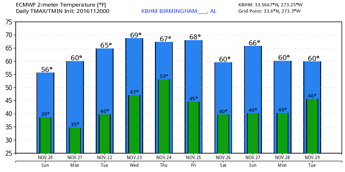
The current satellite showed us a crystal clear morning across Alabama and the whole Southeast US. Temperatures dropped pretty much as forecast with freezing values across the northern half of Alabama. As usual, the range of values can be fairly large. I have seen reports of 23 degrees at Cottondale, 26 at Black Creek, and 30 at Helena while airport stations were coming in at 28 for Tuscaloosa and 38 at Anniston-Oxford. The upper trough will gradually move eastward as the surface high settles right over Alabama later today and early Monday. This will set the stage for excellent radiational cooling tonight and Monday morning, so look for morning lows on Monday to be primarily in the 20s. A freeze warning is in effect for nearly all of Alabama from about 9 pm tonight to 8 am Monday.
For those headed to the beach, you can expect to see sunny days, fair nights, and cooler temps through the middle of the week. Highs will be in the 60s today and Monday from Gulf Shores to Panama City Beach but should warm back into the 70s Tuesday and for the rest half of the week. See the complete Gulf Coast 7 Day Planner here.
If you have plans for the Iron Bowl, Saturday will be the 81st edition of the greatest rivalry in college football. The Auburn Tigers will be heading to Tuscaloosa to take on the Crimson Tide for a 2:30 pm CST kickoff in Bryant-Denny Stadium. The day looks to be mainly sunny with temperatures starting the day in the 40s. The temperatures should be in the mid 60s for kickoff, dropping into the upper 50s by the final whistle.
After the chilly start Monday, we should see plenty of sunshine again allowing temperatures to climb into the upper 50s. The trough will be replaced by an upper ridge on Tuesday, so it will not be as cold. Morning lows on Tuesday will again flirt with the 32-degree mark, but the sunshine should see afternoon highs push into the middle 60s.
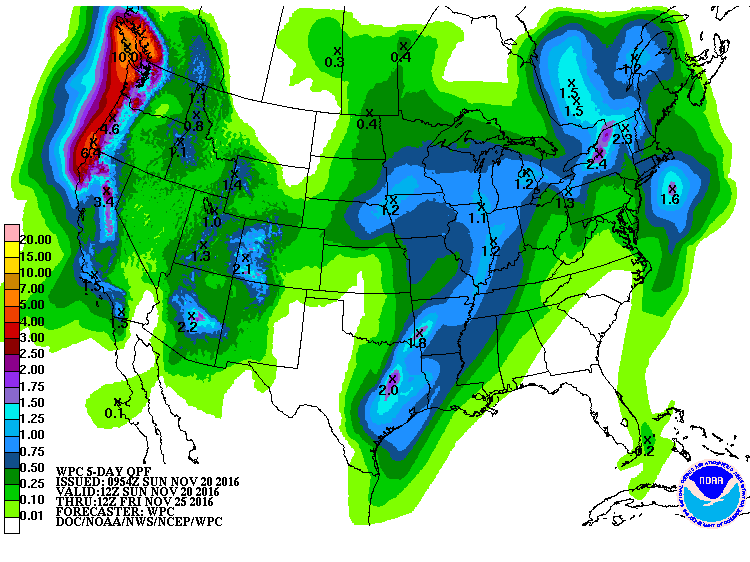
A fast moving upper trough comes at us on Wednesday brining us rain chances once again. This system promises to make Thanksgiving travel a bit wet from the eastern Great Lakes down into the Lower Mississippi River Valley. I think the likelihood of showers is high, but it is still going to be a hit or miss proposition where not everyone gets rain. The GFS is bringing a nice surge of moisture along and just ahead of the front, so there is the potential for places across the northern half of the state to see a third of an inch.
The trough zips right along reaching New England by Thursday as we come back under another upper ridge, so there won’t be much of a cool down – and nothing like what we’ve seeing now. Look for the lows to be in the 40s and highs to be in the 60s. Friday and Saturday will see the weak upper ridge sticking in place so look for mostly sunny days and cool nights with lows around 40 and highs in the 60s.
A pretty substantial trough begins to come toward us on Saturday afternoon. The upper ridge is likely to deflect the best dynamics with this system well to our north, but the GFS is showing some rain over the Southeast US Sunday ahead of the trailing cold front. It’s going to be another one of those situations where we’ll see showers but not everyone gets rain. Best chances appear to be across the northern half of the state. Highs remain in the 60s which is just about right for this time of year.
The pattern out into voodoo country appears to remain active. A really serious looking trough and upper closed low comes out of the Rockies on Tuesday the 29th of November. Unfortunately, the upper ridge is likely to force it northeastward into the Great Lakes, so we’re likely to have a glancing blow with rain chances again. Another vigorous trough is depicted on the 2nd of December. This one looks pretty strong and could have a bigger impact on our weather. Another trough is forecast to come across the Lower Mississippi River Valley around the 5th of December. The screaming message from the GFS is that we’ll have a pretty active pattern.
James Spann will have the next Weather Xtreme Video here bright and early on Monday morning. Stay warm in this chilly spell. Don’t forget to protect any pets that you have that stay outdoors. Any plants that are sensitive to cold weather should also be protected. Heave a great day and Godspeed.
-Brian-
Category: Alabama's Weather
About the Author (Author Profile)
Brian Peters is one of the television meteorologists at ABC3340 in Birmingham and a retired NWS Warning Coordination Meteorologist. He handles the weekend Weather Xtreme Videos and forecast discussion and is the Webmaster for the popular WeatherBrains podcast.Subscribe
If you enjoyed this article, subscribe to receive more just like it.


