

Beneficial Rain/Strong Storms Ahead
Here is an updated look at the rain/storm situation coming up in the days ahead for Alabama…
ROUND ONE: We are still expecting two rounds of rain and thunderstorms. Concerning “round one”, showers will begin to form across Alabama during the day tomorrow, but the most organized band of rain and storms will come tomorrow night into early Tuesday morning, generally between 8:00 p.m. and 6:00 a.m.
SPC has a “marginal risk” of severe storms up for far West Alabama tomorrow night…
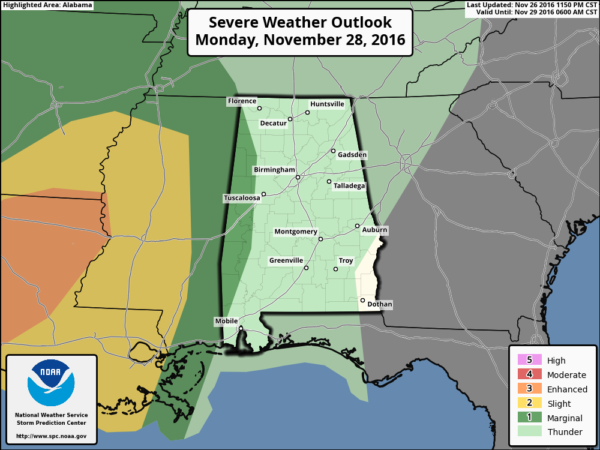
The storms will be strong initially as they move into West Alabama with potential for gusty winds and some small hail, but the overall severe weather risk is rather low with limited instability and wind fields that are less than impressive.
There are many Christmas parades scheduled across North/Central Alabama tomorrow night… stronger storms could impact West Alabama as early as 7:00 p.m… but for the rest of the state there is a decent chance those heavier storms arrive after the parades are over. But, understand lighter, scattered showers will be around during the early evening hours.
Most of the day Tuesday will be dry, with a mix of sun and clouds, as we wait on…
ROUND TWO: Another short wave embedded in a southwest flow aloft will bring more rain and storms to Alabama Tuesday night and Wednesday. Dewpoints will surge into the 60s Tuesday night, making for an unstable atmosphere with CAPE values to 500/750 j/kg over much of the state. SPC has most of the state in a “marginal risk” of severe storms for round two, with the standard “slight risk” from about Livingston and Linden south to Mobile…
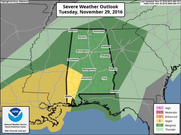
It is difficult to really determine the actual severity of the threat at this point, we need to see the condition of the atmosphere after “round one” ends Tuesday morning. But, for now it looks like a fairly limited threat for the northern half of the state with potential for strong winds and some hail. Higher risk of a tornado Tuesday night and Wednesday could seem to be over far Southwest Alabama with the better combination of instability, lift, and shear.
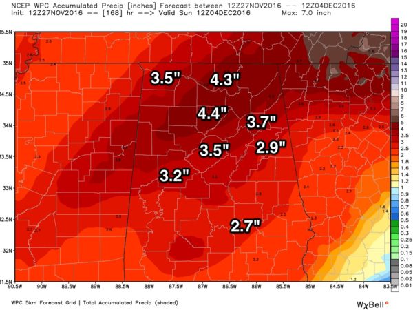
RAIN TOTALS: New data from NOAA’s WPC (Weather Prediction Center) continues to suggest some really beneficial rain for Alabama, and the drought stricken Southeast U.S. For North/Central Alabama, rain amounts of 2-4 inches are likely from tomorrow through Thursday.
Something we can call celebrate. Keep an eye on the blog for updated forecasts over the next few days as we go through our first high impact weather event (other than the drought) in many months…
Category: Alabama's Weather
About the Author (Author Profile)
James Spann is one of the most recognized and trusted television meteorologists in the industry. He holds the AMS CCM designation and television seals from the AMS and NWA. He is a past winner of the Broadcast Meteorologist of the Year from both professional organizations.Subscribe
If you enjoyed this article, subscribe to receive more just like it.


