

Two Rounds Of Heavy Rain/Storms Ahead
THIS AFTERNOON: Rain continues to fall across Northwest Alabama this afternoon as “round one” of our two punch system impacts the Deep South. To the west, tornado watches cover much of Mississippi and Louisiana, where the air is more unstable and dynamic support is strong.
STRONG GRADIENT WINDS: Here in Alabama, strong south winds of 15-30 mph continue as the pressure gradient continues to tighten; ridge tops could see non thunderstorm winds gusting to 50 mph this evening, with potential for tree and power line damage. A wind advisory is in effect for most of Alabama.
ROUND ONE: A line of strong storms will move across Alabama tonight; the high resolution HRRR model suggests the line will be moving through places like Birmingham/Tuscaloosa/Anniston/Gadsden in the 8-11 p.m. time frame.
Instability values should be rather marginal tonight, limiting the severe weather potential. Still, storms tonight could produce strong, possibly damaging winds, and an isolated tornado can’t be totally ruled out, mainly over West Alabama. A severe weather watch could be required, as well as a few warnings. Pay close attention to them if they are needed.
The rain tapers off after midnight.
TOMORROW: A decent part of the day tomorrow will be dry with a mix of sun and clouds, although a few widely scattered showers are possible. Temperatures rise into the mid to upper 70s, and dew points will show a steady rise during the day as well with a big jump in low level moisture.
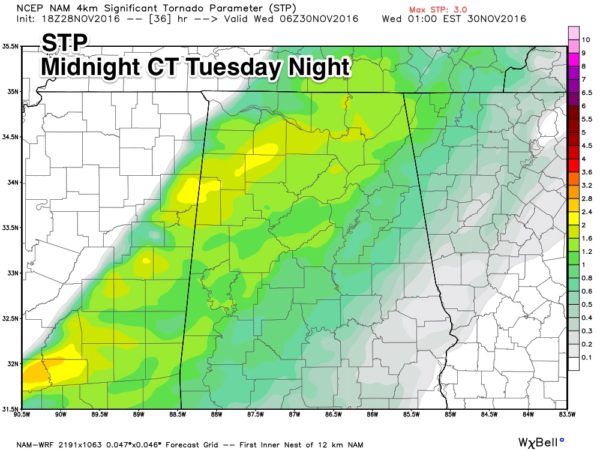
ROUND TWO: A more significant severe weather threat is shaping up for Alabama tomorrow night… SPC has much of North and West Alabama in the standard “slight risk”…
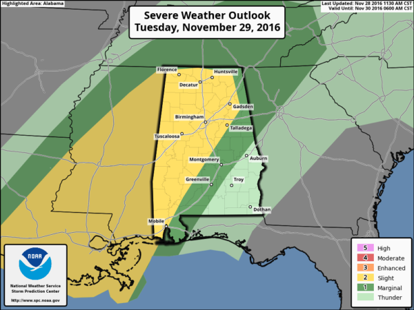
Dewpoints will be in the mid to upper 60s, surface based CAPE values (instability) will rise to near 1,500 j/kg, and a strengthening low level jet will bring potential for all modes of severe weather, including large hail, damaging straight line winds, and a few tornadoes. The main window for severe weather will come from 10:00 tomorrow night through 8:00 a.m. Wednesday.
RAIN: We still project rain amounts in the 2-4 inch range for North/Central Alabama through Wednesday, with amounts of 1-2 inches for the southern counties of the state. Remember, we need 8 to 12 inches to get rid of the drought, but this will start the process in fine fashion. We could very well see some flooding issues during the heavier storms with a high level of runoff expected.
REMEMBER: We haven’t had active weather in a long time. Be sure you can hear severe weather watches and warnings if they are needed. And, since this active weather will come during the late night/pre-dawn hours, be sure you have a NOAA Weather Radio properly programmed with a battery backup. A good warning app needs to be on your phone as well, like WeatherRadio by WDT.
And, you might want to review your “action plan” with the family just in case. Your safest place is a small room on the lowest floor, near the center of the house, and away from windows. You don’t have to be underground. And, if you live in a mobile home you have to get out, and into a safe place in a site built structure.
If by chance we go go into “wall to wall” severe weather coverage, you can watch us on the ABC 33/40 mobile apps…
ABC 33/40 iOS App
ABC 33/40 Android App
FOOTBALL WEATHER: For the 7A Alabama high school football championship game in Auburn (McGill-Toolen Catholic vs. Hoover)… the good news is that it now looks like most of the rain will be gone in time for the 7pm kickoff, just an outside chance of a lingering shower. Temperatures will fall into the 50s during the game. Auburn will be rain-free for the rest of the games Thursday and Friday.
THURSDAY/FRIDAY: These two days will be cool and dry, with ample sunshine along with highs in the 50s and lows in the 30s.
THE WEEKEND: Saturday looks dry; beyond that confidence is low due to conflicting model output. Rain could return to Alabama as early as Sunday… the GFS holds the rain off until Monday night and Tuesday of next week. We will have a higher confidence forecast for the weekend in a few days after “rounds one and two” are gone.
WEATHER BRAINS: Don’t forget you can listen to our weekly 90 minute netcast anytime on the web, or on iTunes. This is the show all about weather featuring many familiar voices, including our meteorologists here at ABC 33/40.
CONNECT: You can find me on all of the major social networks…
Facebook
Twitter
Google Plus
Instagram
I enjoyed speaking at the Rotary Club meeting today at Centre… look for the next Weather Xtreme video here by 7:00 a.m. tomorrow…
Category: Alabama's Weather
About the Author (Author Profile)
James Spann is one of the most recognized and trusted television meteorologists in the industry. He holds the AMS CCM designation and television seals from the AMS and NWA. He is a past winner of the Broadcast Meteorologist of the Year from both professional organizations.Subscribe
If you enjoyed this article, subscribe to receive more just like it.


