

Morning Storms, Afternoon Clearing
RADAR CHECK: A long line of strong storms is pushing southward across Alabama early this morning…
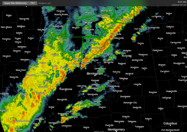
Flash flood warnings are in effect for Cullman, Morgan, and parts of Madison, Marshall, and Jackson counties, where rain amounts have exceeded two inches in many places.
The good news is that we have no active severe thunderstorm or tornado warnings (as of 6:15am), but a tornado watch remains in effect for parts of Northeast, Central, and Southwest Alabama until 10 a.m. CT. I would say the main threats this morning will come from flooding and gusty straight line winds, but an isolated tornado can’t be ruled out. In fact a storm moving into Bibb County is showing signs of rotation as I write this shortly after 6:00 a.m.
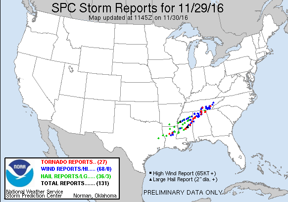
TRAGIC NIGHT: At least three people died in a tornado in the small Jackson County community of Rosalie last night, and four children were critically injured after a tornado struck a 24 hour daycare facility at Ider, in DeKalb County. Tornado damage was reported in parts of Pickens, Lamar, Marion, Winston, Jackson, Madison, and DeKalb counties. We will know much more later this morning after the sun comes up and NWS survey teams get into the field.
THE DAY AHEAD: Rain and storms will end from northwest to southeast, and we will begin to see some clearing this afternoon as drier air works into the state. Temperatures will fall slowly during the day.
TOMORROW/FRIDAY: Cool, dry weather with sunny days and clear nights; highs from 57 to 60 tomorrow, followed by low 60s Friday. Lows will be in the 30s.
FOOTBALL WEATHER: For the 7A Alabama high school football championship game in Auburn tomnight (McGill-Toolen Catholic vs. Hoover)… the good news is that it now looks like most of the rain will be gone in time for the 7pm kickoff, just an outside chance of a lingering shower. Temperatures will fall into the 50s during the game. Auburn will be rain-free for the rest of the games tomorrow and Friday.
THE ALABAMA WEEKEND: Clouds increase Saturday, and another round of rain is likely statewide Sunday. Highs for the weekend should be in the 50s; the air Sunday will be stable and no severe weather is expected (probably no thunder).
NEXT WEEK: Unsettled, potentially stormy weather is the story through Wednesday night with occasional showers and thunderstorms. Another setup for strong to severe storms is shaping up by Wednesday based on global model runs. Then, the coldest air so far this season invades the state by Thursday and Friday; the GFS is evening hinting at snow flurries Thursday (don’t count on it!). See the Weather Xtreme video for maps, graphics, and more details.
WEATHER BRAINS: Don’t forget you can listen to our weekly 90 minute netcast anytime on the web, or on iTunes. This is the show all about weather featuring many familiar voices, including our meteorologists here at ABC 33/40.
CONNECT: You can find me on all of the major social networks…
Facebook
Twitter
Google Plus
Instagram
Look for the next Weather Xtreme video here by 4:00 this afternoon, and stay tuned to the blog for updates through the morning as the storms work south and east…
Category: Alabama's Weather
About the Author (Author Profile)
James Spann is one of the most recognized and trusted television meteorologists in the industry. He holds the AMS CCM designation and television seals from the AMS and NWA. He is a past winner of the Broadcast Meteorologist of the Year from both professional organizations.Subscribe
If you enjoyed this article, subscribe to receive more just like it.


