

Soaking Rain Tonight; Arctic Blast By Thursday
RADAR CHECK: Yet another large mass of rain is moving up into North/Central Alabama this afternoon…
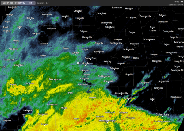
The air is cool and stable with temperatures in the upper 40s and low 50s, meaning we expect no severe weather problems over the northern half of the state tonight.
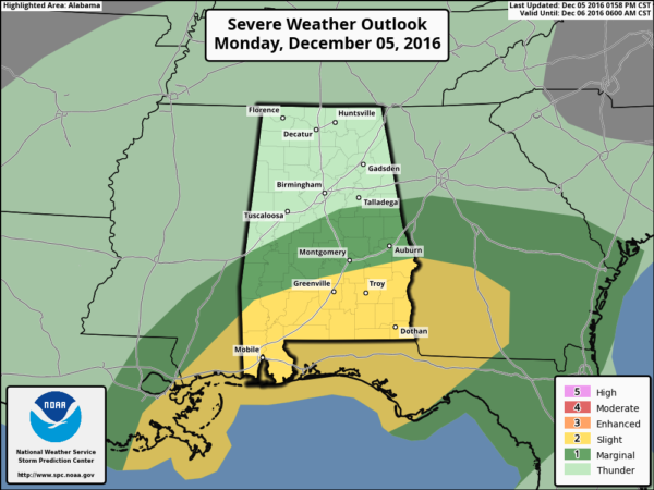
However, to the south, the air is unstable near the Gulf Coast, and a tornado watch remains in effect until 8:00 p.m. for the broad zone from Mobile Bay to Panama City. In Alabama, only three counties are included… Baldwin, Geneva, and Houston.
SPC maintains the standard “slight risk” of severe storms for South Alabama tonight…
Additional rain amounts of at least one inch are likely tonight; rain ends early tomorrow morning as a surface low pulls away to the northeast. Clouds linger much of the day tomorrow, however, with a high in the upper 50s.
Wednesday looks cool and dry with a mix of sun and clouds along with a high between 55 and 59 degrees.
ARCTIC BLAST THURSDAY/FRIDAY: An Arctic front invades Alabama Thursday. Moisture will be limited, but some light rain is possible ahead of the front. The big story is the cold air; the high Thursday will be only in the low 40s with a biting north wind of 15-30 mph, making it feel much colder. By Friday morning, temperatures will be down in the 19-22 degree range. And, during the day Friday, we won’t make it out of the 30s despite sunshine in full supply. Some communities up in the Tennessee Valley will stay below freezing all day Friday.
Despite what the rumor mill is producing, there is no risk of any winter weather mischief Thursday and Friday. I guess it is possible somebody might see a few light snow flurries over Northeast Alabama Thursday evening, but it won’t amount to anything, and there is no impact.
THE ALABAMA WEEKEND: The low Saturday morning will be down in the 17-21 degree range; Birmingham’s record low for December 10 is 13 (set in 1995)… most likely that is safe despite the cold air intrusion. The say Saturday will be sunny with a high in the upper 40s. Then, clouds return Sunday, and some light rain could move in from the west Sunday afternoon ahead of the next wave aloft. Moisture will be limited, so rain amounts should be light through Sunday night.
NEXT WEEK: Some light rain could linger on Monday, followed by drier weather through mid-week. Then, global models show another Arctic blast toward the end of next week… see the Weather Xtreme video for maps, graphics, and more details.
“NO BURN” ORDER LIFTED: Here is a release from the Alabama Forestry Commission…
“Effective immediately, Governor Robert Bentley and Interim State Forester Gary Cole have rescinded the statewide Drought Emergency ‘No Burn’ Order which has been in effect since early November. Officials with the Alabama Forestry Commission (AFC) say the state has received enough rainfall over the last few days to reduce the threat of dangerous wildfires.
“In recent days we have seen significant rainfall across our state and the Alabama Forestry Commission now believes the worst of the drought has ended,” Governor Bentley said. “I want to thank the Forestry Commission and the dozens of local fire departments that have worked so hard to ensure the thousands of wildfires didn’t get out of hand. These men and women have worked long hours under intense conditions to prevent as much damage as possible. We will continue to work with stake holders across the state to help everyone recover from the drought.”
According to Cole, “Although all counties in the state will return to having burn permits available, we should bear in mind that Alabama like much of the South is still experiencing extreme drought conditions this fall. The AFC will continue to monitor ground moisture levels throughout the state. If ground fuels become exceptionally dry again, it may be necessary to re-issue a Fire Alert or No Burn Order in affected areas.”
The AFC advises anyone conducting any type of outdoor burning to follow safety precautions such as not leaving a fire unattended until it is completely out, having the necessary equipment and personnel to control the fire, and having a garden hose or other water supply on hand for smaller debris burns. Any fire more than a quarter-acre in size or within 25 feet of a forested area requires a permit from the AFC.”
WEATHER BRAINS: Don’t forget you can listen to our weekly 90 minute netcast anytime on the web, or on iTunes. This is the show all about weather featuring many familiar voices, including our meteorologists here at ABC 33/40.
CONNECT: You can find me on all of the major social networks…
Facebook
Twitter
Google Plus
Instagram
Look for the next Weather Xtreme video here by 7:00 a.m. tomorrow…
Category: Alabama's Weather
About the Author (Author Profile)
James Spann is one of the most recognized and trusted television meteorologists in the industry. He holds the AMS CCM designation and television seals from the AMS and NWA. He is a past winner of the Broadcast Meteorologist of the Year from both professional organizations.Subscribe
If you enjoyed this article, subscribe to receive more just like it.


