

Turning Sharply Colder Tomorrow
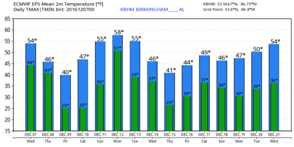
COOL, DRY DECEMBER DAY: Not sure we see much sun today, but the day will be dry with a high in the mid 50s. We note the average high for December 7 for Birmingham is 58.
ARCTIC FRONT BLOWS IN TOMORROW: Moisture will be very limited, but we might see a few raindrops or sprinkles with the front tomorrow morning. But, clearly the big story is the incoming cold air; we won’t get past the mid 40s, and a north wind of 15-25 mph will make it feel colder.
By Friday morning we will drop into the 20-25 degree range, and despite sunshine in full force Friday’s high will be between 38 and 41 degrees.
The coldest morning will come early Saturday, when we project a low between 18 and 22 degrees for most communities across North/Central Alabama.
THE ALABAMA WEEKEND: A warming trend begins Saturday afternoon; with a sunny sky we expect a high in the upper 40s. Then, on Sunday, clouds return to the state, and it looks like rain could move into North Alabama as early as Sunday afternoon. A few periods of rain are likely Sunday night into early Monday morning; rain amounts of about 1/2 inch are likely.
NEXT WEEK: The GFS model is suggesting some light rain is possible across the state Tuesday and Wednesday, followed by yet another blast of very cold, Arctic air Thursday and Friday. There is no evidence of any ice or snow issues for Alabama for the next seven days, but the pattern continues to look cold on into that following week. See the Weather Xtreme video for maps, graphics, and more details…
WARNING: We are now in the season where some weather enthusiasts like to play the “forecast snow two weeks in advance” game. They search for long range (out to 384 hour) global model output that shows some kind of snow or ice event, and post it across their social media platforms and blogs, knowing it will bring thousands of clicks, likes, and shares. That horse left the barn several years ago and there is nothing we can do about it, but just understand there is little to no skill in a specific weather forecast beyond seven days. I could light it up with wild, bogus snow forecasts two weeks in advance, knowing my audience numbers would grow to massive levels. But, professionals don’t post fantasy land snow maps for clicks and likes; it is simply unethical.
PLEASE THINK BEFORE YOU SHARE these irresponsible forecasts across social media.
WEATHER BRAINS: Don’t forget you can listen to our weekly 90 minute netcast anytime on the web, or on iTunes. This is the show all about weather featuring many familiar voices, including our meteorologists here at ABC 33/40.
CONNECT: You can find me on all of the major social networks…
Facebook
Twitter
Google Plus
Instagram
Look for the next Weather Xtreme video here by 4:00 this afternoon…
Category: Alabama's Weather
About the Author (Author Profile)
James Spann is one of the most recognized and trusted television meteorologists in the industry. He holds the AMS CCM designation and television seals from the AMS and NWA. He is a past winner of the Broadcast Meteorologist of the Year from both professional organizations.Subscribe
If you enjoyed this article, subscribe to receive more just like it.


