

Frigid Nights Ahead For Alabama
COLD IS THE WORD: Temperatures are mostly in the low to mid 40s across Alabama this afternoon with a brisk north wind making it feel colder; tonight will be the coldest night since February 10, when Birmingham had a low of 23 degrees. Most communities will fall into the 20 to 25 degree range early tomorrow morning with a clear sky. A north wind of 6-12 mph will push the wind chill index down into the teens by daybreak.
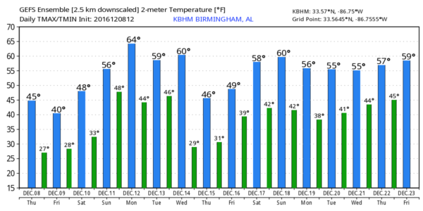
Tomorrow will be cold and dry with a good supply of sunshine; the high will be in the low 40s, although communities up over far North Alabama will stay in the 30s all day.
THE ALABAMA WEEKEND: It begins with another very cold morning; the low Saturday will be in the low 20s for most places, but with a clear sky and light wind, radiational cooling will bring temperatures down into the mid to upper teens for colder valleys. Then, during the day, the sky will be sunny and Saturday’s high will be in the upper 40s.
Sunday will be warmer with a partly sunny sky; the high Sunday afternoon will be in the upper 50s. Clouds return Sunday night.
NEXT WEEK: A rather complex pattern is setting up across Alabama and the Deep South. A wave will bring some rain to the state Monday; rain should be fairly light with limited moisture (generally under 1/2 inch). And, the warming trend continues as temperatures return to the 60s Monday afternoon. For now Tuesday looks dry and cooler with a high in the 50s, but rain returns Wednesday ahead of another Arctic front. For now it looks like about 1/2 inch of rain can be expected, and more cold air follows the front for Thursday and Friday with highs dropping into the low 40s, and lows down in the 20s.
The 12Z run of the GFS continues to hint at some risk of snow flurries over North Alabama Wednesday evening, but the reliable European model says no, and we will roll with that solution for now since it has better skill in the medium range. One way or another we see no evidence of any meaningful snow or ice event for Alabama for the next 7-10 days.
NEW DROUGHT MONITOR: Please understand Alabama is still in an exceptional/severe drought, despite the good rain over the past two weeks…
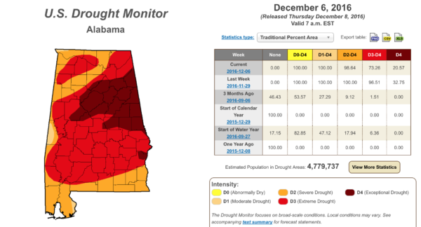
Birmingham’s rain deficit for the year is 11.09″… the deficiency at Anniston is 15.71″. It takes time to get into a drought, and time to get out of one as well.
WEATHER BRAINS: Don’t forget you can listen to our weekly 90 minute netcast anytime on the web, or on iTunes. This is the show all about weather featuring many familiar voices, including our meteorologists here at ABC 33/40.
CONNECT: You can find me on all of the major social networks…
Facebook
Twitter
Google Plus
Instagram
I had a great time today visiting with the 3rd graders at Ohatchee Elementary in Calhoun County… be looking for them on the Pepsi KIDCAM today at 5:00 on ABC 33/40 News! The next Weather Xtreme video will be posted here by 7:00 a.m. tomorrow…
Category: Alabama's Weather
About the Author (Author Profile)
James Spann is one of the most recognized and trusted television meteorologists in the industry. He holds the AMS CCM designation and television seals from the AMS and NWA. He is a past winner of the Broadcast Meteorologist of the Year from both professional organizations.Subscribe
If you enjoyed this article, subscribe to receive more just like it.


