

Cold December Day
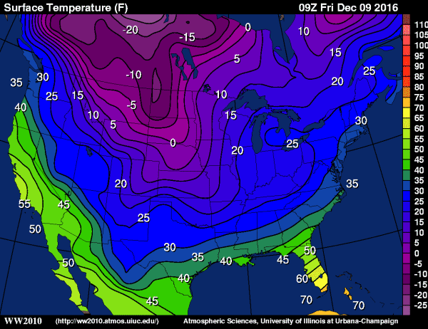
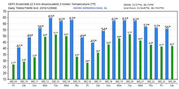
ARCTIC AIR SETTLES IN: The average high for December 9 in Birmingham is 57… we will be about 15 degrees below that level today as Arctic air continues to settle into the state.
We are starting the day with temperatures in the 20s, and with a north wind of 5-10 mph wind chill indices are lower. At 6:00 this morning, Birmingham reports 26 degrees with a north wind of 6 mph, making the wind chill index 19.
Later today, despite sunshine in full force, we won’t get past the low 40s. Many communities over the northern quarter of the state will hold in the 30s all afternoon.
Tonight will feature another very significant freeze; the wind falls off to near calm, and the colder spots across North/Central Alabama will have a chance to reach the teens. Most of the official reporting stations will be in the low 20s early tomorrow.
THE ALABAMA WEEKEND: Tomorrow will be mostly sunny and slightly warmer with a high in the upper 40s. Then, Sunday will feel much better as temperatures reach the upper 50s by afternoon with a partly sunny sky. Clouds increase Sunday night.
NEXT WEEK: A complex and active pattern sets up across the Deep South. We will mention a chance of rain showers Monday; the warming trend continues with temperatures rising well into the 60s. For now it looks like the best chance of showers Tuesday will come over the southern counties of the state, but rain should increase again statewide Wednesday with the approach of another Arctic cold front. The latest GFS run suggests highs will hold in the 60s Tuesday and Wednesday, and rain amounts for the first first half of the week will be around 1/2 inch.
Much colder air begins to spill into the state Wednesday night, and Thursday and Friday for now are looking dry and cold with highs in the 40s.
I guess it is conceivable a few snow flurries are possible Wednesday night over North Alabama as the cold air moves into the state, but it wouldn’t be anything meaningful. It is important to note we see no issues with snow or ice across North or Central Alabama for the next 7 to 10 days despite these occasional shots of cold air.
WEATHER BRAINS: Don’t forget you can listen to our weekly 90 minute netcast anytime on the web, or on iTunes. This is the show all about weather featuring many familiar voices, including our meteorologists here at ABC 33/40.
CONNECT: You can find me on all of the major social networks…
Facebook
Twitter
Google Plus
Instagram
I have a weather program this morning at Shades Mountain Elementary in Hoover… look for the next Weather Xtreme video here by 4:00 this afternoon. Enjoy the day!
Category: Alabama's Weather
About the Author (Author Profile)
James Spann is one of the most recognized and trusted television meteorologists in the industry. He holds the AMS CCM designation and television seals from the AMS and NWA. He is a past winner of the Broadcast Meteorologist of the Year from both professional organizations.Subscribe
If you enjoyed this article, subscribe to receive more just like it.


