

Much Colder Tomorrow; Complex Weekend Forecast
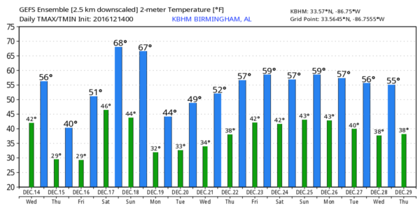
COOL TODAY, COLD TOMORROW: Low clouds blanket Alabama early this morning; we expect the sky to become partly sunny this afternoon with a high in the mid to upper 50s. Then, an Arctic front blows in here in dry fashion tonight, and will bring another surge of sharply colder air tomorrow. The high tomorrow will be only in the 41-45 degree range despite a sunny sky, and a significant freeze is likely early Friday with most places dropping into the mid 20s.
The sky will be partly to mostly sunny Friday with a high in the mid 50s.
COMPLICATED WEEKEND FORECAST: The air over Alabama will undergo a very quick change Saturday as a stiff southerly wind sets up ahead of an approaching storm system. The latest guidance is now suggesting temperatures surge into the low to mid 70s Saturday afternoon, with developing showers during the day, especially Saturday afternoon. It will be a very balmy December day.
An Arctic front will enter North Alabama late Saturday night, setting up a very interesting period of weather for the state with two distinct threats…
STRONG TO SEVERE STORMS: SPC has introduced a risk of severe storms for parts of West Alabama for Saturday night and early Sunday morning, including places like Muscle Shoals, Hamilton, Fayette, Jasper, Tuscaloosa, and Demopolis. Dewpoints will surge into the mid 60s late Saturday and Saturday night, making the air unstable with surface CAPE values to 750 j/kg in spots.
For now, it looks like the main window for severe storms will come from about 10:00 Saturday night through 10:00 Sunday morning, mainly west of I-65 (west of places like Cullman, Birmingham, and Clanton). A few storms during this time frame could produce gusty winds and hail, and an isolated tornado can’t be totally ruled out. We will be able to fine tune this forecast as we get closer to the weekend.
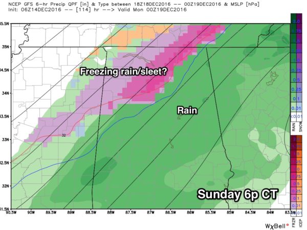
WINTRY MIX??? Temperature forecasting on Sunday will be a nightmare with a strong Arctic front moving through the state. At midday Sunday, we could very well have a 50 degree thermal gradient across Alabama, with 30 degrees at Muscle Shoals, and 80 degrees at Dothan.

If you are in a place like Birmingham, Tuscaloosa, or Anniston, you will probably wake up with temperatures in the upper 60s, feeling more like a summer morning. But, by the time you walk out of church a 30 degree drop is likely with a very cold north wind. People that don’t pay attention to the weather will be totally unprepared.
And, as the cold air rushes in Sunday, there seems to be some chance the rain could change to a “wintry mix” of sleet or freezing rain before the precipitation ends. This idea is still being presented by the GFS model.
A few important points…
*The cold air initially will be very shallow, so it is very unlikely that there will be any snow flakes involved if there is a changeover.
*If we do see some freezing rain or sleet, it won’t last long, and the infrastructure will be warm from Saturday’s high in the low to mid 70s.
*The reliable European model (the ECMWF) shows the rain ending with no issues with freezing rain or sleet Sunday.
Bottom line is that there is some outside chance we could see some freezing rain or sleet over the northern third of Alabama (mainly north of U.S. 278) Sunday, but if that does happen we expect little or no impact at this point. Take some time to see the Weather Xtreme video for all the maps, graphics, and more details.
On the positive side, we expect rain amounts of 1-2 inches over the weekend. No, that won’t end the drought, but it will be beneficial.
NEXT WEEK: Monday for now looks cold and dry, then we warm up a bit with a good rain event shaping up later in the week in the Wednesday-Thursday time frame. Too early to know if that will bring any threat of severe storms to the state. And, for now, temperatures look seasonal around Christmas weekend with highs in the 50s…
REMEMBER: This IS the tornado season in Alabama. Our two core peaks here come in spring, March, April, and May… and late fall/early winter… November and December. Having severe storms at Thanksgiving and Christmas is not unusual.
WEATHER BRAINS: Don’t forget you can listen to our weekly 90 minute netcast anytime on the web, or on iTunes. This is the show all about weather featuring many familiar voices, including our meteorologists here at ABC 33/40.
CONNECT: You can find me on all of the major social networks…
Facebook
Twitter
Google Plus
Instagram
Look for the next Weather Xtreme video here by 4:00 this afternoon… enjoy the day!
Category: Alabama's Weather
About the Author (Author Profile)
James Spann is one of the most recognized and trusted television meteorologists in the industry. He holds the AMS CCM designation and television seals from the AMS and NWA. He is a past winner of the Broadcast Meteorologist of the Year from both professional organizations.Subscribe
If you enjoyed this article, subscribe to receive more just like it.


