

Wild Weather Swings Through The Weekend
NEVER A DULL MOMENT in the weather office in Alabama in December. There will be many fast paced changes over the next four days with everything from freezing temperatures, soaking rain, and severe storms along the way. You might want to watch the Weather Xtreme video to see all of the maps and graphics associated with this discussion and for more insight.
ARCTIC COLD TODAY: Temperatures are generally in the 27-35 degree range early this morning, and despite a sunny sky we don’t expect to get past the low 40s this afternoon. Many communities over the northern quarter of the state won’t get out of the 30s.
We project a low between 22 and 25 degrees for most places early tomorrow morning with a clear sky. Then, a warming trend begins tomorrow afternoon with temperatures reaching the mid 50s along with a partly sunny sky.
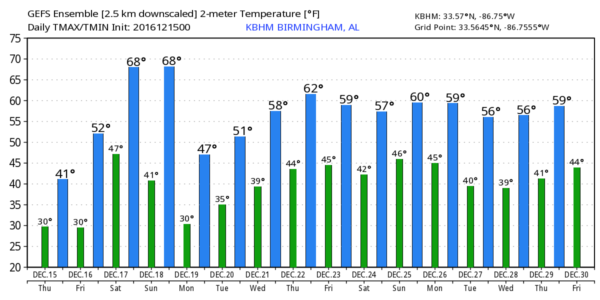
ONE DAY WARMTH SATURDAY: Temperatures will rise about 50 degrees from the lows tomorrow morning to highs Saturday afternoon. Most places will see a high in the low 70s Saturday as southerly winds return and we see a quick warm-up. The sky will be mostly cloudy, and occasional showers are likely, mostly along and north of I-20 (Tuscaloosa to Birmingham to Anniston).
SEVERE WEATHER RISK SATURDAY NIGHT/EARLY SUNDAY: SPC has the standard “slight risk” of severe storms up late Saturday night for far West Alabama, with a “marginal risk” as far east as Birmingham. Keep in mind this “Day Three” outlook is valid through 6:00 a.m. Sunday…
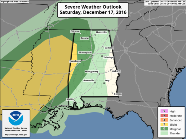
Dewpoints will surge into the mid 60s Saturday night across the state, making the air unstable. Surface based CAPE values will rise to almost 500 j/kg in spots. Keep in mind it doesn’t take much instability for severe storms in the cold season. And, low level helicity values will be rather high in the immediate zone ahead of the next approaching Arctic front.
A few storms ahead of the front could become strong to severe, with potential for some hail, strong, gusty winds, and an isolated tornado or two. Highest risk of severe storms will be west of I-65, over the western half of the state. And, the main window for strong to severe storms will come from about 10:00 p.m. Saturday through 6:00 a.m. Sunday.
You will want to be sure you have a good, properly programmed NOAA Weather Radio on in your home with a battery backup so you won’t miss any “middle of the night” warnings if they are needed. And, a good smart phone app like WeatherRadio by WDT is a great second tier of receiving severe weather warnings.
ARCTIC PLUNGE SUNDAY: A sharp Arctic front will be near I-59 at 6:00 Sunday morning…
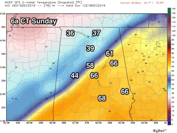
If you live in a place like Greensboro, Alabaster, Clanton, Sylacauga, or Anniston, it will be warm and balmy early Sunday morning, but understand temperatures will drop like a rock, and by midday you will be in the 30s. For most, the high Sunday will come sometime between 12:01 a.m. and 7:00 a.m.
WINTRY MIX FOR FAR NORTH ALABAMA? There remains some outside chance there could be a touch of freezing rain or sleet over far North Alabama as the precipitation event winds down Sunday. Best chance of this happening would be over the northwest corner of Alabama and the higher terrain locations of far North Alabama and southern Middle Tennessee. If we do see any freezing rain or sleet, we don’t expect any impact on travel or anything else at this point.
RAIN AMOUNTS: Totals of 1-2 inches are likely this weekend, great news for a state in the midst of an exceptional drought. Keep in mind some places need 15 inches to get back to average levels for the year.
NEXT WEEK AND BEYOND: For now the weather looks cool and dry Monday through Wednesday, followed by periods of rain Thursday and Friday. And, peeking out into the long range it looks like some risk of rain will continue over the Christmas weekend.
WEATHER BRAINS: Don’t forget you can listen to our weekly 90 minute netcast anytime on the web, or on iTunes. This is the show all about weather featuring many familiar voices, including our meteorologists here at ABC 33/40.
CONNECT: You can find me on all of the major social networks…
Facebook
Twitter
Google Plus
Instagram
I have a weather program this morning for the kids in the HeadStart program in Attalla… look for the next Weather Xtreme video here by 4:00 this afternoon. Enjoy the day!
Category: Alabama's Weather
About the Author (Author Profile)
James Spann is one of the most recognized and trusted television meteorologists in the industry. He holds the AMS CCM designation and television seals from the AMS and NWA. He is a past winner of the Broadcast Meteorologist of the Year from both professional organizations.Subscribe
If you enjoyed this article, subscribe to receive more just like it.


