

Trending Warmer In Coming Days
THIS MORNING: Quite frankly our beloved computer models, the heart of NWP (numerical weather prediction), have been struggling with this pattern. Most models had us in the 40s yesterday, but almost all reporting stations in the state remained in the 30s with a stubborn cloud deck. And, those clouds are still around this morning.
Temperatures have been steady, or slowly rising during the pre-dawn hours, and most communities are in the mid to upper 30s. We will forecast morning clouds giving way to a partly sunny afternoon, and where the sun does break out temperatures should reach the low 50s today. But, where clouds hang tough, the high will be in the 40s.
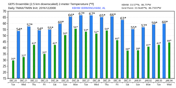
REST OF THE WEEK: With a brighter sky tomorrow, a good chance we touch the 60 degree mark. And, dry weather continues Thursday and Friday with highs between 56 and 61 with a partly to mostly sunny sky.
CHRISTMAS WEEKEND: A southerly flow will bring moist air back up into Alabama, and accordingly the sky will be mostly cloudy both days. The GFS is now suggesting a few showers are possible Saturday over the northern third of the state, and we will introduce that possibility into the forecast. And, on Christmas Day, a few scattered showers are possible, but nothing heavy or widespread. Temperatures will be mild; low 60s are likely Saturday, followed by upper 60s Sunday. South Alabama will likely see low 70s Sunday afternoon. Sorry snow fans, not even a remote chance of a snow flake around here.
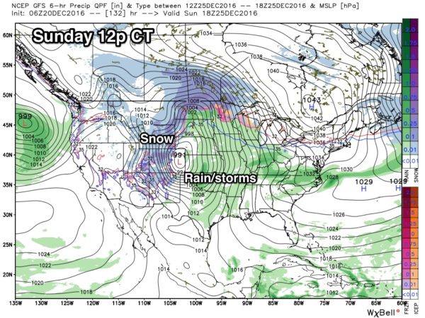
A significant storm system will set up this weekend over the nation’s mid-section, with snow likely over states like Colorado and Wyoming, and showers and strong storms in the warm sector across the Great Plains…
NEXT WEEK: We will maintain the risk of showers into the first part of next week as moist air stays in place, but the main dynamic support will be north and west of Alabama thanks to an upper high setting up over Florida. Unfortunately rain amounts should remain on the light side. Also, temperatures will stay mild with highs well up in the 60s much of next week as the Polar Express will be shut down for a while.
See the Weather Xtreme video for maps, graphics, and more details.
WEATHER BRAINS: Don’t forget you can listen to our weekly 90 minute netcast anytime on the web, or on iTunes. This is the show all about weather featuring many familiar voices, including our meteorologists here at ABC 33/40. Scroll down for the show notes on the new episode we recorded last night.
CONNECT: You can find me on all of the major social networks…
Facebook
Twitter
Google Plus
Instagram
Look for the next Weather Xtreme video here by 4:00 this afternoon… enjoy the day!
Category: Alabama's Weather
About the Author (Author Profile)
James Spann is one of the most recognized and trusted television meteorologists in the industry. He holds the AMS CCM designation and television seals from the AMS and NWA. He is a past winner of the Broadcast Meteorologist of the Year from both professional organizations.Subscribe
If you enjoyed this article, subscribe to receive more just like it.


