

Foggy, Then Sunny And Warmer
FREEZING FOG ADVISORY: Freezing fog is simply fog that forms when surface temperatures are at or below freezing, and we have that situation over North Alabama early this morning. Where the fog is dense, some patchy bridge icing is possible, so take a little extra time to get to work this morning. To the south, where temperatures are above freezing, we have a “dense fog advisory” all the way down to the Gulf Coast.
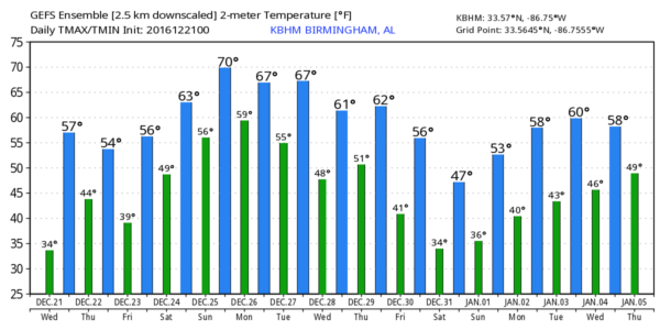
The good news… once the fog burns off today will brighter and warmer, with ample sunshine and a high around 60 degrees.
TOMORROW/FRIDAY: Dry, pleasant weather continues both days. A partly to mostly sunny sky with afternoon highs holding near 60 degrees.
CHRISTMAS WEEKEND: A southerly flow will push moist air up into the state, and the sky becomes mostly cloudy Saturday. A few showers are possible, but the most widespread rain will be over the Tennessee Valley of far North Alabama. Christmas Day for now looks mostly cloudy and mild with the risk of a few widely scattered showers; we could very well touch 70 degrees Sunday afternoon.
CHRISTMAS CLIMATOLOGY IN ALABAMA: For Birmingham on December 25, the average high is 54, and the average low is 34. But you rarely will find a Christmas with those numbers. On the warm side, people in Alabama were outside in their shorts and t-shirts on Christmas Eve, 1964 when the temperature soared to 77 degrees. Our warmest Christmas Day on record came last year, when the high in Birmingham was also 77.
FYI… the warmest December temperature on record is 80, recorded on December 7, 1951.
No, having mild weather at Christmas is not unusual at this low latitude. In Alabama, it never “gets cold and stays cold”. If you are looking for that kind of winter, head north. But, from time to time, we can have Arctic blasts in late December. The coldest Christmas morning on record came in 1983, when the low in Birmingham was 2 degrees above zero. In 1989, on December 23, the temperature dropped to 1 degree.
NEXT WEEK: A surface front will stall out just north of here, so it looks like Monday and Tuesday will stay mostly cloudy with a chance of showers, but nothing especially heavy or widespread; highs will be in the 60s.
WEATHER BRAINS: Don’t forget you can listen to our weekly 90 minute netcast anytime on the web, or on iTunes. This is the show all about weather featuring many familiar voices, including our meteorologists here at ABC 33/40.
CONNECT: You can find me on all of the major social networks…
Facebook
Twitter
Google Plus
Instagram
Look for the next Weather Xtreme video here by 4:00 this afternoon… enjoy the day!
Category: Alabama's Weather
About the Author (Author Profile)
James Spann is one of the most recognized and trusted television meteorologists in the industry. He holds the AMS CCM designation and television seals from the AMS and NWA. He is a past winner of the Broadcast Meteorologist of the Year from both professional organizations.Subscribe
If you enjoyed this article, subscribe to receive more just like it.


