

Very Mild Christmas Weekend Ahead
TRENDING WARMER: Dry weather will continue across Alabama through tomorrow with partly sunny days and fair nights; the high should be in the 60-65 degree range both days.
The upper air pattern has changed across North America, and the “gates to the Yukon” are closed for now, shutting off the flow of very cold, Arctic air. As an upper high develops over Florida and the Gulf of Mexico, creeping into Alabama from the south, it will set the stage for a warm Christmas weekend.
SATURDAY/SUNDAY: With a southerly flow, moisture will increase Saturday, and a few showers are possible, but it sure looks like the best chance of rain will come near the Tennessee border, with only isolated showers to the south. The sky will be mostly cloudy, and temperatures will reach the mid to upper 60s.
There are few guarantees in weather, but we can pretty much say with very high confidence there won’t be a white Christmas in Alabama this year. Keep in mind, Birmingham has never had measurable snow on the ground on Christmas morning since weather records started in the late 1800s, so based on climatology the chance of a snowy Christmas morning here is about 0.05%. We do note it snowed on Christmas morning six years ago in 2010, and some communities across North Alabama did have enough snow to measure that rare day.
Sunday will be mostly cloudy and warm with a high in the low 70s; a shower is possible, but not likely.
NORTH AND WEST OF ALABAMA: For travelers, a major storm will be in progress over the nation’s mid-section, with heavy snow and blizzard conditions possible Sunday over states like Wyoming and North Dakota. In the warm sector, severe storms will be a threat to parts of Oklahoma and Kansas.
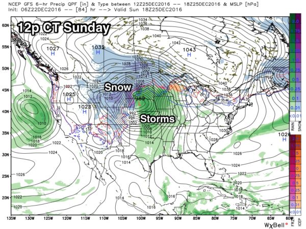
NEXT WEEK: That big storm system over the Central U.S. will lift northward into Canada, and the trailing front should stall out north of Alabama as it becomes parallel to the upper air winds. The week looks generally cloudy and mild with highs in the 60s along with some risk of scattered light showers; rain seems to be most likely later in the week with the approach of another front with better dynamic support. See the Weather Xtreme video for maps, graphics, and more details.
LONG RANGE: The CFS (climate forecast system) model does suggests the return of Arctic cold to the U.S. sometime in late January…
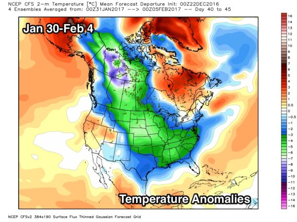
Of course, this is “voodoo” and not a specific forecast, but just an idea based on pattern recognition.
WEATHER BRAINS: Don’t forget you can listen to our weekly 90 minute netcast anytime on the web, or on iTunes. This is the show all about weather featuring many familiar voices, including our meteorologists here at ABC 33/40.
CONNECT: You can find me on all of the major social networks…
Facebook
Twitter
Google Plus
Instagram
Look for the next Weather Xtreme video here by 4:00 this afternoon… enjoy the day!
Category: Alabama's Weather
About the Author (Author Profile)
James Spann is one of the most recognized and trusted television meteorologists in the industry. He holds the AMS CCM designation and television seals from the AMS and NWA. He is a past winner of the Broadcast Meteorologist of the Year from both professional organizations.Subscribe
If you enjoyed this article, subscribe to receive more just like it.


