

The Latest On Alabama’s Drought Situation: 12/22/2016
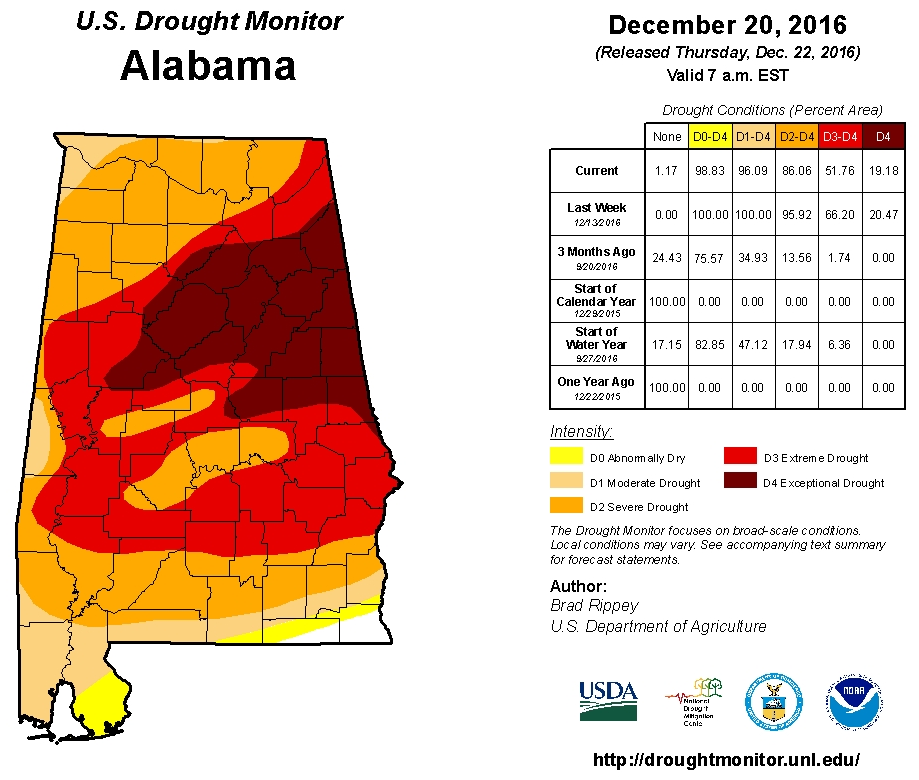
The latest U.S. Drought Monitor continues to show extreme to exceptional drought conditions across the eastern and central counties of Central Alabama. Some improvement continues across northwest and far southern Alabama. Exceptional drought conditions continue over much of the state, with severe to extreme drought conditions across the rest of the state, except over the northwest corner of the state along with the extreme southern parts of the state, where abnormally dry to moderate drought conditions are found.
Rain from the system that moved through the state on December 17-19 brought some improvement in the drought conditions across far northwest and far southern Alabama with totals generally between 1-2 inches in these areas. The rest of the state received generally less than 1 inch. We still could use soaking rains to help the current moisture needs and to shrink the rainfall deficits for the year.
Some precipitation amounts for central Alabama since January 1st:
• Birmingham 39.80 in
• Montgomery 40.88 in
• Anniston 31.39 in
• Tuscaloosa 36.99 in
• Calera 36.93 in
• Troy 39.90 in
Normal precipitation expected and departure from normal January 1st through December 21st:
• Birmingham 52.39 in (-12.59 in)
• Montgomery 51.57 in (-10.69 in)
• Anniston 48.44 in (-17.05 in)
• Tuscaloosa 51.28 in (-14.29 in)
• Calera 53.11 in (-16.18 in)
• Troy 53.35 in (-13.45 in)
Agricultural Impacts
The last USDA report issued indicated that agricultural interests continued to be significantly impacted by the drought with additional ponds and streams reported to be drying up. Cattle producers are said to be supplementing livestock with hay, feed supplements and water hauled from elsewhere. Delays in plating winter crops are reported due to the continued drought.
Fire Danger Impacts
The fire danger risk has decreased across much of the state due to rainfall over the past 30 days. Keetch-Byram drought indices (KBDI) currently range from <50 to 500 across the state with the highest values across portions of Jefferson, Shelby, Bibb and Tuscaloosa counties. Values between 300 and 400 can be found across portions of St. Clair, Cherokee, Cleburne, Sumter and Choctaw counties. Values above 500 indicate a severe fire danger.
While the statewide burn ban has been rescinded, there remains concern that many pine trees could still die due to the drought. The state forester continues to urge people that are doing any outside burning to follow safety precautions such as not leaving any fire unattended and having the proper equipment and personnel to control the fire.
Since October 1st, over 2,260 wildfires have occurred over Alabama, and over 29,800 acres have burned. At this time any lingering wildfires are contained according to the Alabama forestry commission.
Hydrologic Summary And Outlook
USGS stream gage data indicates that below normal stream flows are occurring across much of central Alabama while near or at normal stream flows are being measured across far North Alabama, along with across roughly the southern third of the state. Periodic rainfall will need to occur for stream flows to return to normal or better levels across the central portion of the state.
Social Impacts
Pools have been near their normal winter levels at most major reservoirs. Voluntary and mandatory water restrictions have been implemented by many water boards across Central Alabama and are still in effect in some areas.
Category: Headlines
About the Author (Author Profile)
Scott Martin is an operational meteorologist, professional graphic artist, musician, husband, and father. Not only is Scott a member of the National Weather Association, but he is also the Central Alabama Chapter of the NWA president. Scott is also the co-founder of Racecast Weather, which provides forecasts for many racing series across the USA. He also supplies forecasts for the BassMaster Elite Series events including the BassMaster Classic.Subscribe
If you enjoyed this article, subscribe to receive more just like it.


