

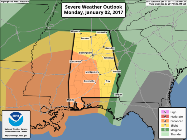
Severe Weather Threat Tomorrow
After another cool, wet day, a strong southerly flow develops across Alabama tomorrow, bringing warmth, unstable air, and the threat of severe storms. SPC has now upgraded the threat; there is an “enhanced” severe weather threat for much of West and Southwest Alabama… including Tuscaloosa, Brent, Greensboro, Demopolis, Selma, Camden, and other communities down to the Gulf Coast. The standard “slight risk” of severe storms covers most of the rest of the state…
METEOROLOGICAL SETUP: Dewpoints will surge into the 60s, with temperatures rising into the low 70s tomorrow, making for an unstable atmosphere; surface based CAPE values will rise to well over 1,000 j/kg by mid to late afternoon. An approaching wave aloft will bring support for storms, along with a surface low moving out of Texas, which will bring surface winds around to the southeast. There will also be considerable strengthening of lower/mid wind fields, including southerly 40-50 knot flow around 850 mb (5,000 feet), veering to west/southwesterly at 50-70 knots around 700 mb (10,000 feet). This should provide more than sufficient low-level and deep layer shear for organized severe convection, including supercells.
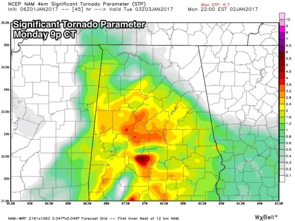
TIMING: Strong to severe storms are possible across Alabama in the 2:00 p.m. to 12:00 midnight time frame. Some of the highest STP (Significant Tornado Parameter) values from the NAM model come tomorrow night…
But, again, severe storms will be possible during the afternoon as well.
THREATS: Thunderstorms across Alabama tomorrow afternoon and tomorrow night will be capable of producing damaging straight line winds, hail, and a few tornadoes. According to the Storm Prediction Center, “A strong tornado or two may not be out of the question.”
CALL TO ACTION: Tomorrow is a holiday for most, meaning many families will be traveling and not in their usual place on a Monday. So, be sure you have a way of hearing severe weather watches and warnings. At home, you need a properly programmed NOAA Weather Radio with a battery backup. On your phone, for warnings we recommend WeatherRadio by WDT. You can watch our live severe weather coverage on the free ABC 33/40 app. Here are the links…
ABC 33/40 iOS version for iPhones and iPads
ABC 33/40 Android version for Android phones and tablets
Review your action plan in case a tornado warning polygon includes your home. Get in a small room, on the lowest floor, away from windows, and near the center of the house. You do NOT have to be underground. Never be in a car or mobile home.
WINTER MISCHIEF LATER IN THE WEEK: We have to get through the severe weather threat tomorrow before we can really have any confidence about the forecast late in the week, but there is still some chance of light wintry precipitation showing up across North Alabama Friday night or Saturday morning. For now it seems like a low end, low impact issue, but again we won’t have any confidence in this forecast until mid-week.
Keep an eye on the blog for updates!
Category: Alabama's Weather
About the Author (Author Profile)
James Spann is one of the most recognized and trusted television meteorologists in the industry. He holds the AMS CCM designation and television seals from the AMS and NWA. He is a past winner of the Broadcast Meteorologist of the Year from both professional organizations.Subscribe
If you enjoyed this article, subscribe to receive more just like it.


