

Severe Weather Threat to Kick Off the New Year
A significant severe weather threat is on the table for Monday afternoon and Monday evening across Central Alabama. The greatest threat for a couple of tornadoes will be south of US-82 from Tuscaloosa to Montgomery and points south, but all of Alabama has a risk for severe weather.
SETTING THE STAGE: By late tonight, a southerly flow will begin to increase across the area in response to big high pressure to the east and developing low pressure to the west. By noon, that surface low will be over eastern Texas. Another round of showers and thunderstorms will break out by noon across Central Alabama as the warm front lifts north. Some of those storms could be strong, but shouldn’t get out of hand.
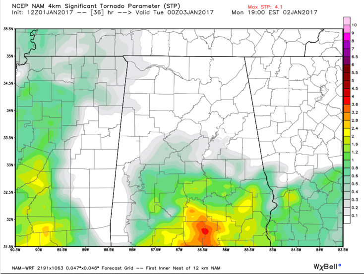
Significant tornado parameter from the 4km NAM model for Monday evening at 6 p.m. Values over 1 are indicative of an environment capable of producing EF2 or greater tornadoes.
STRONGEST STORMS BY AFTERNOON: The best chance will come from mid-afternoon on as the surface low lifts northeast into Mississippi. Instability should ramp up with CAPE values increasing to between 600-1,200 joules/kg, which is certainly sufficient for strong thunderstorm updrafts. There will be good speed shear with winds increasing to 40-50 mph at 5000 feet out of the southwest. This will allow storms to be organized and supercell storms will not be out of the question. Directional shear should be strong, with southeasterly winds at the surface, veering to southwesterly through the lower levels of the atmosphere. This means a potential tornado threat.
THREAT AREA: Once again, there is considerable confusion in National Weather Service products, with the Strom Prediction Center putting nearly all of Alabama in their Slight Risk, or standard severe weather category, meaning scattered severe storms possible, and areas south of US-82 in their enhanced category, meaning numerous severe storms possible. I think the SPC risk area is justified based on the instability and shear profiles we see for late tomorrow afternoon and evening.
TORNADO THREAT: I think the SPC is correct in their thinking that a strong tornado or two is not out of the question in the enhanced risk area south of US-82 late tomorrow afternoon and evening. The peak threat time may come between 6-9 p.m.
TIMING: General thunderstorms from noon to 3 p.m. along the warm front, with more intense thunderstorms developing by 2-3 p.m., and continuing through the late evening hours until midnight.
Category: Severe Weather
About the Author (Author Profile)
Bill Murray is the President of The Weather Factory. He is the site's official weather historian and a weekend forecaster. He also anchors the site's severe weather coverage. Bill Murray is the proud holder of National Weather Association Digital Seal #0001 @wxhistorianSubscribe
If you enjoyed this article, subscribe to receive more just like it.


