

A Few Showers; Warming Trend Continues
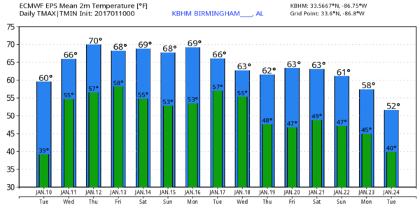
CLOUDS INCREASING: Expect a mostly cloudy sky across North/Central Alabama through tomorrow, and we will mention the chance of a few showers, but the most widespread rain will be to the north, closer to the Tennessee border near a surface front that is stalling out. Temperatures will hold in the 50s tonight, and we will rise into the upper 60s tomorrow afternoon as the warming trend continues.
A good chance we touch 70 degrees Thursday afternoon, and as an upper ridge begins to build the chance of a shower will be pretty small, although clouds will linger much of the state.
MILD WEEKEND: Friday through Sunday we project highs in the 70-74 degree range with a mix of sun and clouds each day. The upper ridge will keep the rain west and north of the state over the weekend; it will be a very nice preview of spring.
NEXT WEEK: The ridge weakens a bit, allowing a storm system to bring rain back to the state on Tuesday; the latest GFS is a little weaker with the system, suggesting rain amounts under 1/2 inch and no risk of severe storms. Relatively mild weather will continue through the rest of the week; see the Weather Xtreme video for maps, graphics, and more details.
35 YEARS AGO: On January 10, 1982, the low in Birmingham was 2 degrees… it would drop to 1 below zero the following day. Then, in coming days, Birmingham would experience one of its worst ice storms of the twentieth century as freezing rain and sleet swept into Central Alabama about midday on January 12, 1982. Morning forecasts had called for a winter storm watch for occasional sleet and freezing rain that would arrive by sundown. By mid-morning, as freezing rain and sleet across South Alabama was spreading rapidly north, the watch was changed to a winter storm warning.
The snow arrived about 8 hours earlier than anticipated in the Birmingham area and quickly changed over to a mix of freezing rain and sleet that turned roads in skating rinks. Thousands of motorists had to abandon their vehicles on roads and hike home or spend the night in shelters. Brookwood Village mall became a huge shelter. So many wrecks occurred that the Birmingham Police Department could not answer the calls for accident investigation. As temperatures hovered near the freezing mark through the night, freezing rain created a thick coating on all exposed objects. Trees snapped, pulling down power lines and putting as many as 750,000 Alabamians in the dark. A state of emergency was declared in Alabama and National Guard Armories were opened to serve as shelters.
WEATHER BRAINS: Don’t forget you can listen to our weekly 90 minute netcast anytime on the web, or on iTunes. This is the show all about weather featuring many familiar voices, including our meteorologists here at ABC 33/40. We will produce this week’s show tonight at 8:30p CT… you can watch it here.
CONNECT: You can find me on all of the major social networks…
Facebook
Twitter
Google Plus
Instagram
I enjoyed seeing all at the Tuscaloosa Rotary Club today… be looking for the next Weather Xtreme video here by 7:00 a.m. tomorrow…
Category: Alabama's Weather
About the Author (Author Profile)
James Spann is one of the most recognized and trusted television meteorologists in the industry. He holds the AMS CCM designation and television seals from the AMS and NWA. He is a past winner of the Broadcast Meteorologist of the Year from both professional organizations.Subscribe
If you enjoyed this article, subscribe to receive more just like it.


