

Unsettled Weather; Stormy Periods
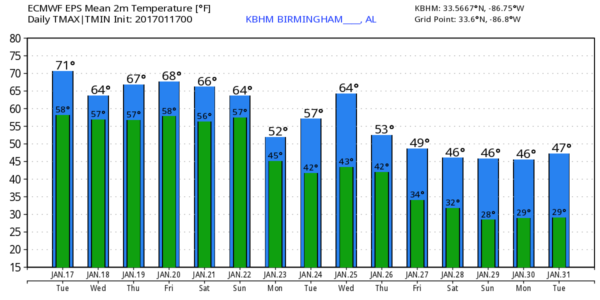
A FEW SHOWERS TODAY: A surface front will approach Alabama from the west today, and we expect showers to move into the state this afternoon and tonight. There is little upper support for the front, so there is no risk of severe weather, and we probably won’t have much thunder. Rain amounts should be under 1/2 inch. Otherwise, expect a mostly cloudy sky with a high in the low 70s again this afternoon, a good 20 degrees above average for mid to late January.
The front will wash out tomorrow; the day will be mostly cloudy with only widely scattered showers. Tomorrow’s high will be in the mid to upper 60s.
SOAKER THURSDAY/THURSDAY NIGHT: An upper trough will approach from the west Thursday, and it looks like widespread rain and thunderstorms will move over the state by afternoon, into Thursday night. SPC has defined a “marginal” risk of severe storms for the southwest part of the state…
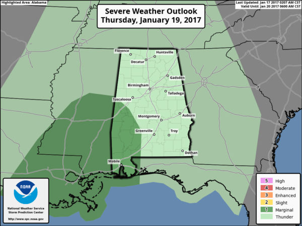
This looks more like a heavy rain event for the northern half of the state with limited instability; any severe storms should be confined to the southern counties of Alabama, and even there it is certainly a “marginal” threat, as SPC suggests. Rain amounts of 1-2 inches are likely, and some minor flooding issues are possible by Thursday night.
FRIDAY: Rain should end during the pre-dawn hours, and most of the day will be dry and warm with a high in the low 70s along with a mix of sun and clouds.
STORMY WEEKEND: A vigorous weather system will approach Alabama over the weekend, and set the stage for a chance of strong to severe thunderstorms, mainly on Sunday. For now Saturday looks fairly quiet, with a mostly cloudy sky and a few scattered showers… the high will be close to 70 degrees. Then, on Sunday, a complex system will bring rain and storms to the state. Instability values will be fairly impressive for January, with surface based CAPE values over 1,500 j/kg during the day. Combined with a steep lapse rate and strong wind fields, this certainly suggests the potential for severe storms. But, 5-6 days in advance it is simply too early to define timing and the magnitude of the threat.
On the positive side, this pattern is very favorable for drought relief; rain amounts could exceed 4 inches over the next seven days.
NEXT WEEK: Monday will be cloudy and sharply colder with a chance of some lingering light rain… parts of North Alabama could hold in the 40s all day. And, toward the end of the week it looks like we will see highs in the 40s and lows in the 20s as cold air settles in. Winter is very young.
See the Weather Xtreme video for maps, graphics, and more details.
As always, watch me for the full weather story on ABC 33/40 News this evening at 4, 5, 6, and 10:00!
WEATHER BRAINS: Don’t forget you can listen to our weekly 90 minute netcast anytime on the web, or on iTunes. This is the show all about weather featuring many familiar voices, including our meteorologists here at ABC 33/40.
CONNECT: You can find me on all of the major social networks…
Facebook
Twitter
Google Plus
Instagram
Snapchat: spannwx
I will have a weather program this morning at Southview Elementary School in Tuscaloosa… look for the next Weather Xtreme video here by 4:00 this afternoon.. .enjoy the day!
Category: Alabama's Weather
About the Author (Author Profile)
James Spann is one of the most recognized and trusted television meteorologists in the industry. He holds the AMS CCM designation and television seals from the AMS and NWA. He is a past winner of the Broadcast Meteorologist of the Year from both professional organizations.Subscribe
If you enjoyed this article, subscribe to receive more just like it.


