

Several Stormy Periods Ahead For Alabama
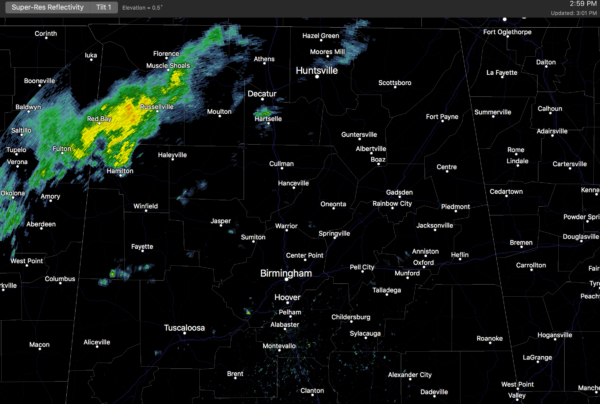
RADAR CHECK: We have a few scattered showers in progress across North Alabama this afternoon, but so far, as expected, rain amounts have been light and spotty…
We will maintain the chance of a few scattered showers tonight and tomorrow with a mostly cloudy sky. Slightly cooler air will filter in from the north tomorrow; the high will drop into the mid 60s, about ten degrees cooler than today.
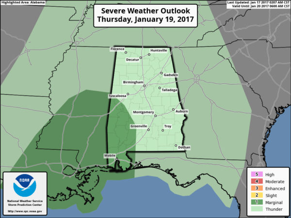
STRONG STORMS THURSDAY/THURSDAY NIGHT: SPC has identified a “marginal” risk of severe storms for Southwest Alabama, roughly from Livingston and Eutaw south to Mobile…
A strong upper trough will approach, and rain and storms should be widespread across the state Thursday afternoon into Thursday night. There will be sufficient shear and instability for strong storms, with the main threat coming from gusty winds and small hail; core severe weather threat will likely stay over the southern half of the state, where instability values will be higher. The rain will be heavy at times, with amounts over one inch likely.
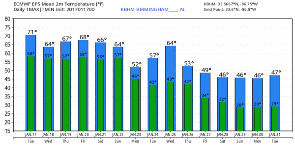
FRIDAY: Rain ends during the pre-dawn hours; the sky becomes partly sunny during the day. And, it stays rather warm for January with a high exceeding 70 degrees once again.
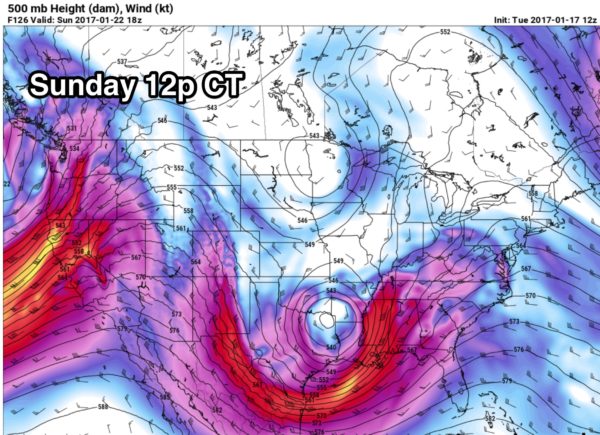
STORMY WEEKEND: Another vigorous weather system will approach the state over the weekend. Showers are possible Saturday, but it won’t be a “wash out” with some sun possible. The main event should hold off until Sunday, when we will have some risk of strong to severe storms. Wind fields look strong, instability values high, and lapse rates fairly steep. This could be a significant severe weather setup, but understand there is no way this early to be very specific about the timing and the magnitude of the threat. We need to get past the Thursday night event before we can see the state of the atmosphere and focus on the weekend situation. Stay tuned.
NEXT WEEK: Colder air returns early next week with highs dropping in the 50s Monday along with clouds and a chance of some lingering light rain. By the end of next week highs should drop into the 40s, and lows in the 20s.
As always, watch me for the full weather story on ABC 33/40 News this evening at 4, 5, 6, and 10:00!
WEATHER BRAINS: Don’t forget you can listen to our weekly 90 minute netcast anytime on the web, or on iTunes. This is the show all about weather featuring many familiar voices, including our meteorologists here at ABC 33/40.
CONNECT: You can find me on all of the major social networks…
Facebook
Twitter
Google Plus
Instagram
Snapchat: spannwx
I had a great time today visiting with the students at Southview Elementary School in Tuscaloosa… be looking for them on the Pepsi KIDCAM today at 5:00 on ABC 33/40 News! The next Weather Xtreme video will be posted here by 7:00 a.m. tomorrow…
Category: Alabama's Weather
About the Author (Author Profile)
James Spann is one of the most recognized and trusted television meteorologists in the industry. He holds the AMS CCM designation and television seals from the AMS and NWA. He is a past winner of the Broadcast Meteorologist of the Year from both professional organizations.Subscribe
If you enjoyed this article, subscribe to receive more just like it.


